Explore historical maps from the Gennadius Library archives
Show Digitized Maps Only:
Advanced Search
Timeline Explorer
Geographic Explorer
Search Results (2399 maps found)
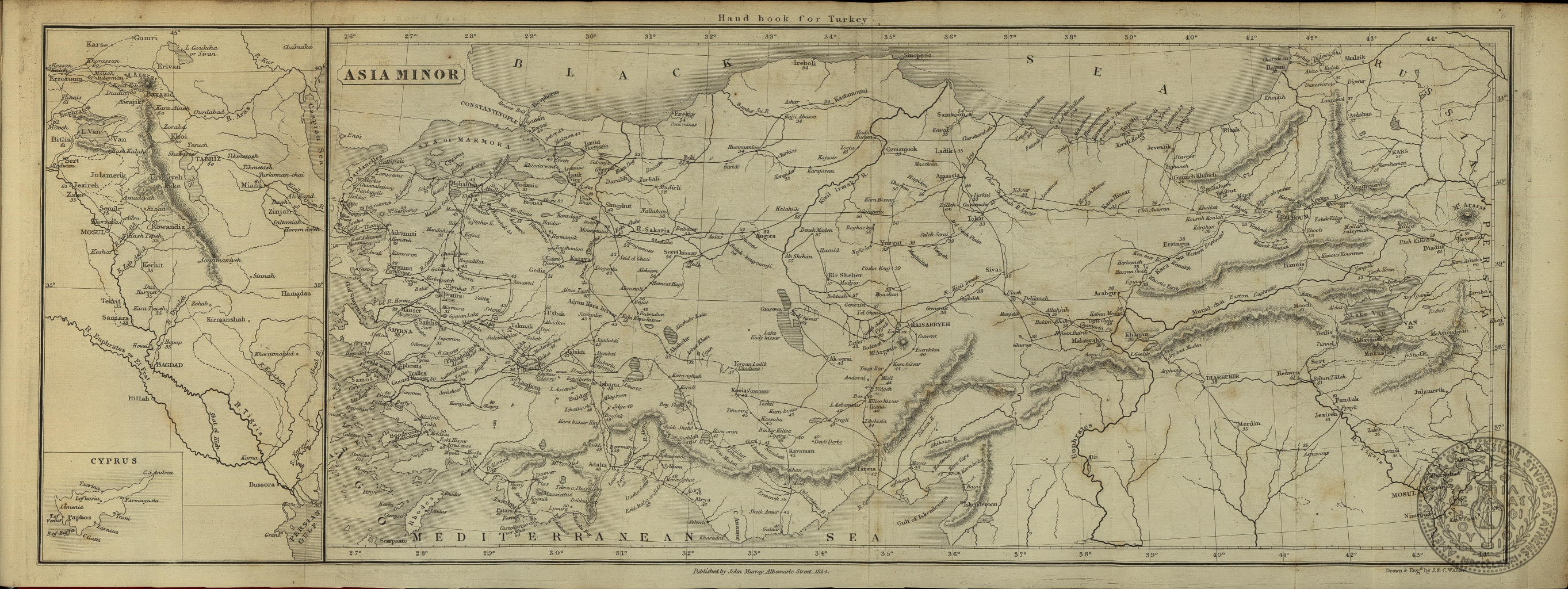
1854
Asia Minor
J. and C. Walker
Asia -- Turkey
Call Number:
GT 825
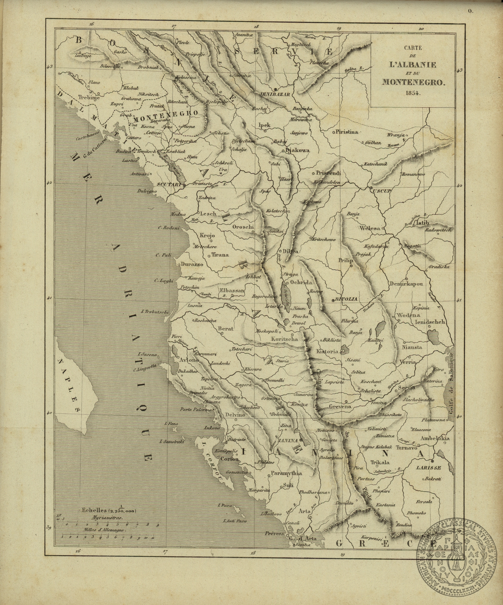
1854
Carte de l'Albanie et du Montenegro
Europe -- The Balkans -- Albania
Call Number:
GT 999 no.4
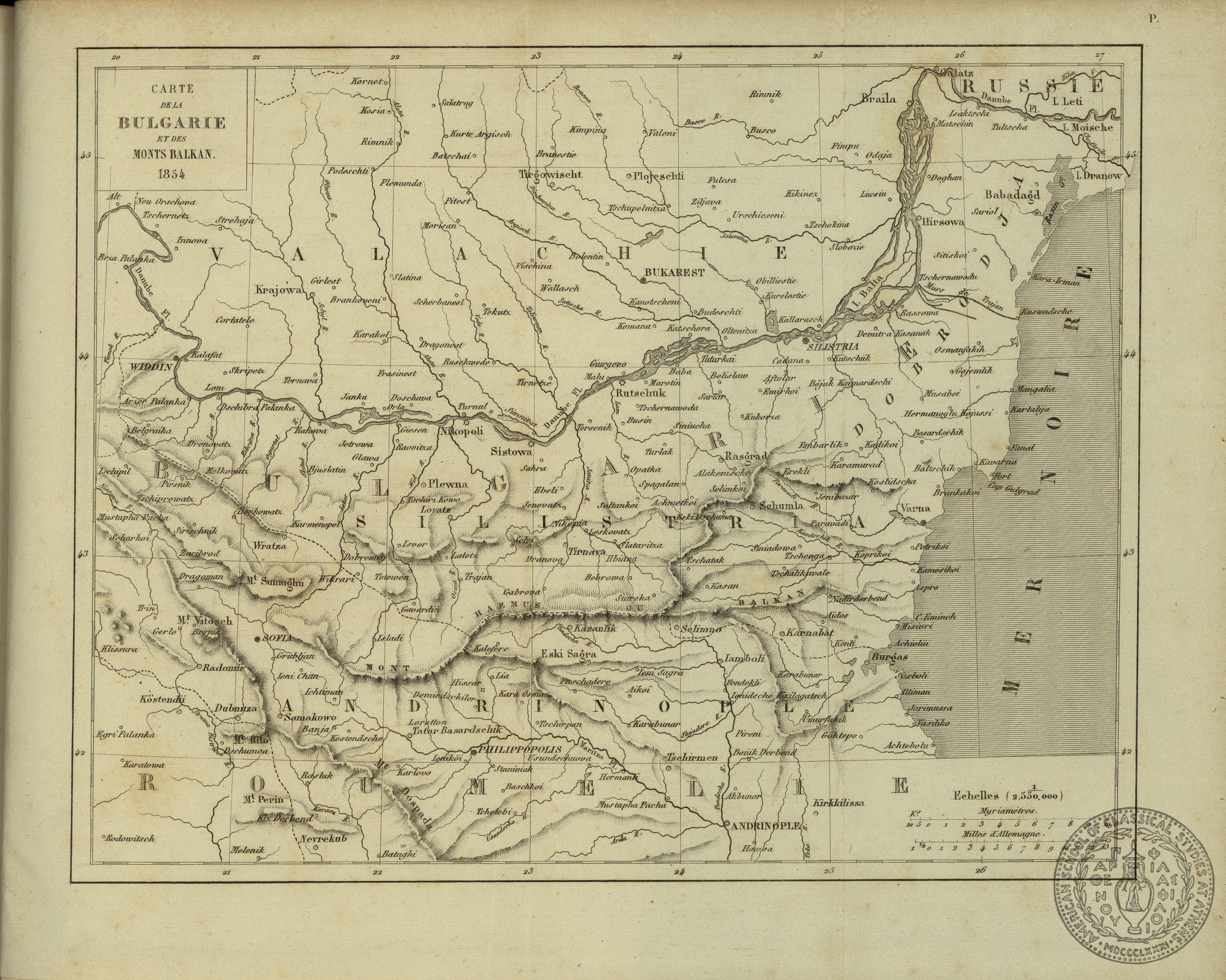
1854
Carte de la Bulgarie et des Monts Balkan
Europe -- The Balkans -- Bulgaria
Call Number:
GT 999 no.4
1854
Moral and statistical chart showing the geographical distribution of man according to Religious Belief, with the principal Protestant Mission Stations in the Middle of the 19th. Century
A. Keith
Atlas
Call Number:
GT 226.35
1856
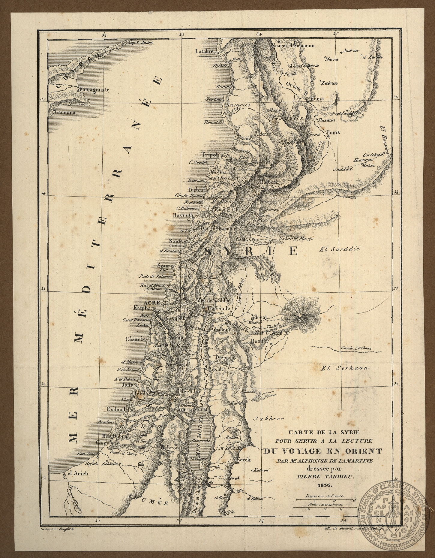
Carte de la Syrie pour servir a la lecture du Voyage en Orient par M.r Alphonse de Lamartine.
Pierre Tardieu
Asia-Syria
Asia-Palestine
Asia-Lebanon
Call Number:
PH 54
1858
Χαρτης της νυν Ελλαδος δια του προς χρησιν των δημοτικων και ελληνικων σχολειον απλαντα.
K. Kolmann
Europe-Greece
Call Number:
PH 29.v.1
1860
Athenes: Plan d' Athenes au XVIIe Sicèle [sic]
Guillet
Europe-Greece-Athens
Call Number:
PH 49.v.1
1861
Χάρτης του Οθωμανικού Κράτους ήτοι Ευρωπαική και Ασιατική Τουρκία
[Map of the Ottoman State that is European and Asian Turkey]
Kolman
Europe -- The Balkans
Asia -- Turkey
Call Number:
GT 271.45
1864
Original-Karte einer im Herbst 1862 von Heinrich Barth ausgefuhrten Reise durch die Europaische Turkei…
H. Kiepert
Europe -- The Balkans -- Bulgaria -- central Bulgaria
Europe -- The Balkans -- Greece -- Macedonia -- central Macedonia, Fyrom, southern Bulgaria
Call Number:
GT 1232
1864
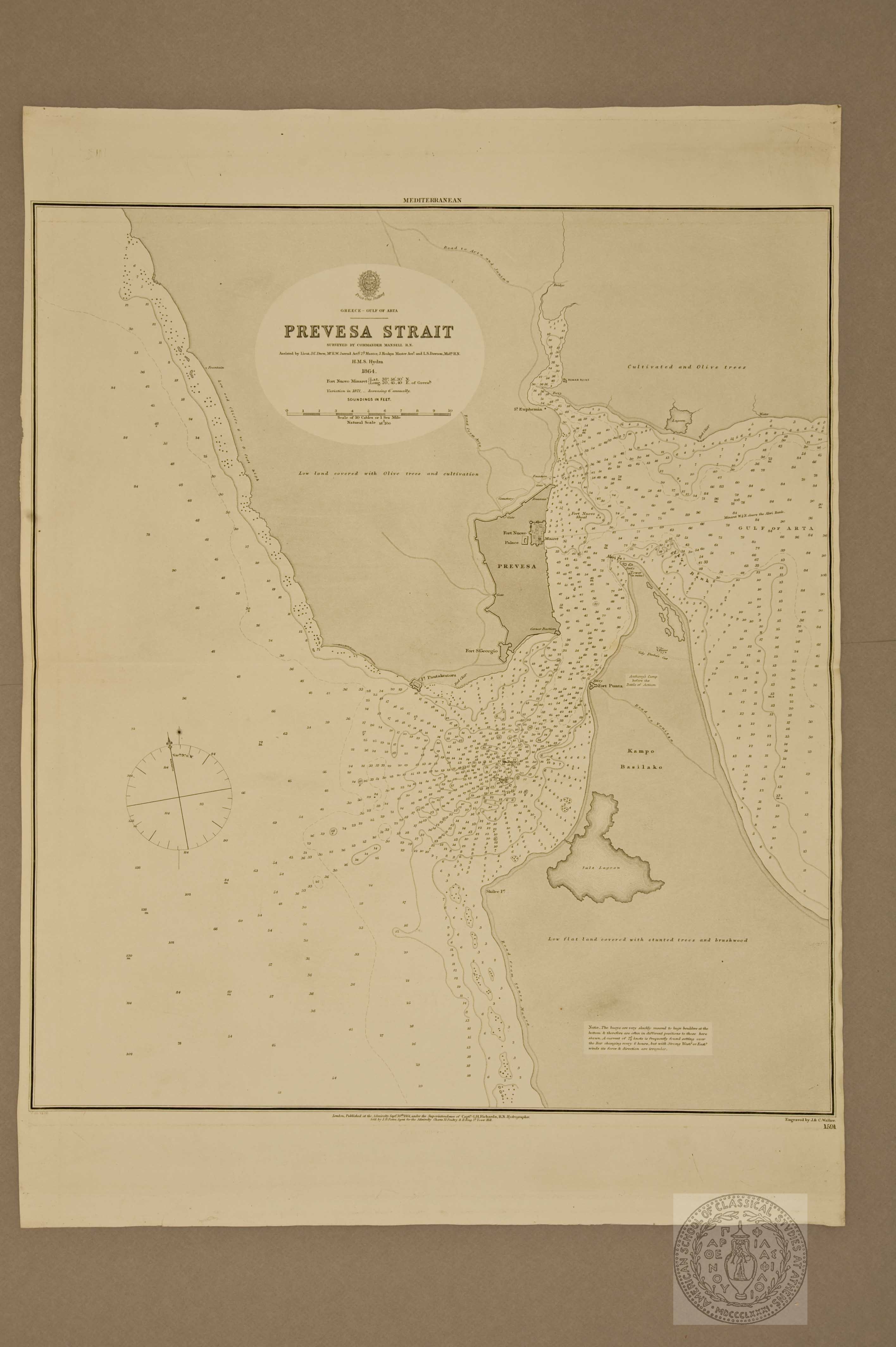
Prevesa Strait
J. and C. Walker
Europe -- The Balkans -- Epirus -- Prevesa
Call Number:
GT 230.51
Asia Minor
Author:
J. and C. Walker
Date:
1854
Publisher:
John Murray
Geographic Coverage:
Asia -- Turkey
Call Number:
GT 825
Carte de l'Albanie et du Montenegro
Date:
1854
Geographic Coverage:
Europe -- The Balkans -- Albania
Call Number:
GT 999 no.4
Carte de la Bulgarie et des Monts Balkan
Date:
1854
Geographic Coverage:
Europe -- The Balkans -- Bulgaria
Call Number:
GT 999 no.4
Moral and statistical chart showing the geographical distribution of man according to Religious Belief, with the principal Protestant Mission Stations in the Middle of the 19th. Century
Author:
A. Keith
Date:
1854
Publisher:
William Blackwood and Sons
Geographic Coverage:
Atlas
Call Number:
GT 226.35
Carte de la Syrie pour servir a la lecture du Voyage en Orient par M.r Alphonse de Lamartine.
Χαρτης της νυν Ελλαδος δια του προς χρησιν των δημοτικων και ελληνικων σχολειον απλαντα.
Author:
K. Kolmann
Date:
1858
Publisher:
G. Th. Pagon
Geographic Coverage:
Europe-Greece
Call Number:
PH 29.v.1
Athenes: Plan d' Athenes au XVIIe Sicèle [sic]
Author:
Guillet
Date:
1860
Geographic Coverage:
Europe-Greece-Athens
Call Number:
PH 49.v.1
Χάρτης του Οθωμανικού Κράτους ήτοι Ευρωπαική και Ασιατική Τουρκία
[Map of the Ottoman State that is European and Asian Turkey]
Author:
Kolman
Date:
1861
Publisher:
Christodoulou
Geographic Coverage:
Europe -- The Balkans
Asia -- Turkey
Call Number:
GT 271.45
Original-Karte einer im Herbst 1862 von Heinrich Barth ausgefuhrten Reise durch die Europaische Turkei…
Author:
H. Kiepert
Date:
1864
Publisher:
D. Reimer
Geographic Coverage:
Europe -- The Balkans -- Bulgaria -- central Bulgaria
Europe -- The Balkans -- Greece -- Macedonia -- central Macedonia, Fyrom, southern Bulgaria
Call Number:
GT 1232
Prevesa Strait
Author:
J. and C. Walker
Date:
1864
Publisher:
Admiralty
Geographic Coverage:
Europe -- The Balkans -- Epirus -- Prevesa
Moral and statistical chart showing the geographical distribution of man according to Religious Belief, with the principal Protestant Mission Stations in the Middle of the 19th. Century
A. Keith
Atlas
Call Number:
GT 226.35
1856
Carte de la Syrie pour servir a la lecture du Voyage en Orient par M.r Alphonse de Lamartine.
Pierre Tardieu
Asia-Syria
Asia-Palestine
Asia-Lebanon
Call Number:
PH 54
1858
Χαρτης της νυν Ελλαδος δια του προς χρησιν των δημοτικων και ελληνικων σχολειον απλαντα.
K. Kolmann
Europe-Greece
Call Number:
PH 29.v.1
1860
Athenes: Plan d' Athenes au XVIIe Sicèle [sic]
Guillet
Europe-Greece-Athens
Call Number:
PH 49.v.1
1861
Χάρτης του Οθωμανικού Κράτους ήτοι Ευρωπαική και Ασιατική Τουρκία
[Map of the Ottoman State that is European and Asian Turkey]
Kolman
Europe -- The Balkans
Asia -- Turkey
Call Number:
GT 271.45
1864
Original-Karte einer im Herbst 1862 von Heinrich Barth ausgefuhrten Reise durch die Europaische Turkei…
H. Kiepert
Europe -- The Balkans -- Bulgaria -- central Bulgaria
Europe -- The Balkans -- Greece -- Macedonia -- central Macedonia, Fyrom, southern Bulgaria
Call Number:
GT 1232
1864
Prevesa Strait
J. and C. Walker
Europe -- The Balkans -- Epirus -- Prevesa
Call Number:
GT 230.51
Asia Minor
Author:
J. and C. Walker
Date:
1854
Publisher:
John Murray
Geographic Coverage:
Asia -- Turkey
Call Number:
GT 825
Carte de l'Albanie et du Montenegro
Date:
1854
Geographic Coverage:
Europe -- The Balkans -- Albania
Call Number:
GT 999 no.4
Carte de la Bulgarie et des Monts Balkan
Date:
1854
Geographic Coverage:
Europe -- The Balkans -- Bulgaria
Call Number:
GT 999 no.4
Moral and statistical chart showing the geographical distribution of man according to Religious Belief, with the principal Protestant Mission Stations in the Middle of the 19th. Century
Author:
A. Keith
Date:
1854
Publisher:
William Blackwood and Sons
Geographic Coverage:
Atlas
Call Number:
GT 226.35
Carte de la Syrie pour servir a la lecture du Voyage en Orient par M.r Alphonse de Lamartine.
Χαρτης της νυν Ελλαδος δια του προς χρησιν των δημοτικων και ελληνικων σχολειον απλαντα.
Author:
K. Kolmann
Date:
1858
Publisher:
G. Th. Pagon
Geographic Coverage:
Europe-Greece
Call Number:
PH 29.v.1
Athenes: Plan d' Athenes au XVIIe Sicèle [sic]
Author:
Guillet
Date:
1860
Geographic Coverage:
Europe-Greece-Athens
Call Number:
PH 49.v.1
Χάρτης του Οθωμανικού Κράτους ήτοι Ευρωπαική και Ασιατική Τουρκία
[Map of the Ottoman State that is European and Asian Turkey]
Author:
Kolman
Date:
1861
Publisher:
Christodoulou
Geographic Coverage:
Europe -- The Balkans
Asia -- Turkey
Call Number:
GT 271.45
Original-Karte einer im Herbst 1862 von Heinrich Barth ausgefuhrten Reise durch die Europaische Turkei…
Author:
H. Kiepert
Date:
1864
Publisher:
D. Reimer
Geographic Coverage:
Europe -- The Balkans -- Bulgaria -- central Bulgaria
Europe -- The Balkans -- Greece -- Macedonia -- central Macedonia, Fyrom, southern Bulgaria
Call Number:
GT 1232
Prevesa Strait
Author:
J. and C. Walker
Date:
1864
Publisher:
Admiralty
Geographic Coverage:
Europe -- The Balkans -- Epirus -- Prevesa


![Athenes: Plan d' Athenes au XVIIe Sicèle [sic]](ESPA\MAPS\MAPS-SCRAPBOOKS\PH 49 v.1_110.jpg)
![Χάρτης του Οθωμανικού Κράτους ήτοι Ευρωπαική και Ασιατική Τουρκία
[Map of the Ottoman State that is European and Asian Turkey]](ESPA\MAPS\MAPS-LOOSE\GT 271.45.jpg)