Explore historical maps from the Gennadius Library archives
Show Digitized Maps Only:
Advanced Search
Timeline Explorer
Geographic Explorer
Search Results (2399 maps found)
[1803]
A map descriptive of the author's route from Constantinople to Jaffa; from thence with the Ottoman Army to Grand Cairo; and his return to Constantinople
J. Russell
Asia -- Turkey, Middle East
Africa -- northern Egypt
Call Number:
GT 712
[1804]
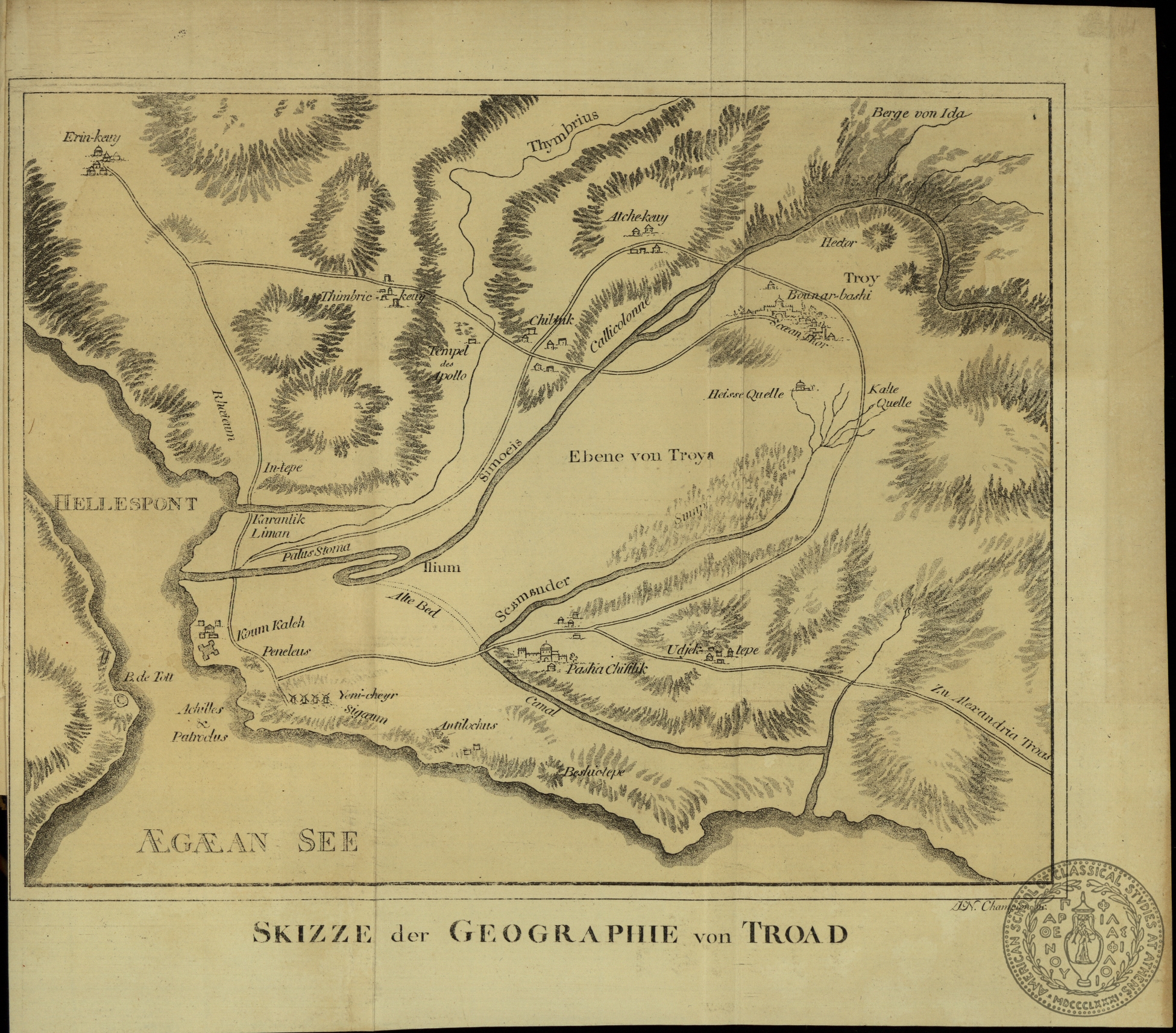
Skizze der Geographie von Troad
Champion
Asia -- Turkey -- region of Troy
Call Number:
GT 709.1
[1804]
Carte de la Basse Egypt
B. Tardieu
Africa -- Egypt
Call Number:
GT 1001.21 Bq
[1804]
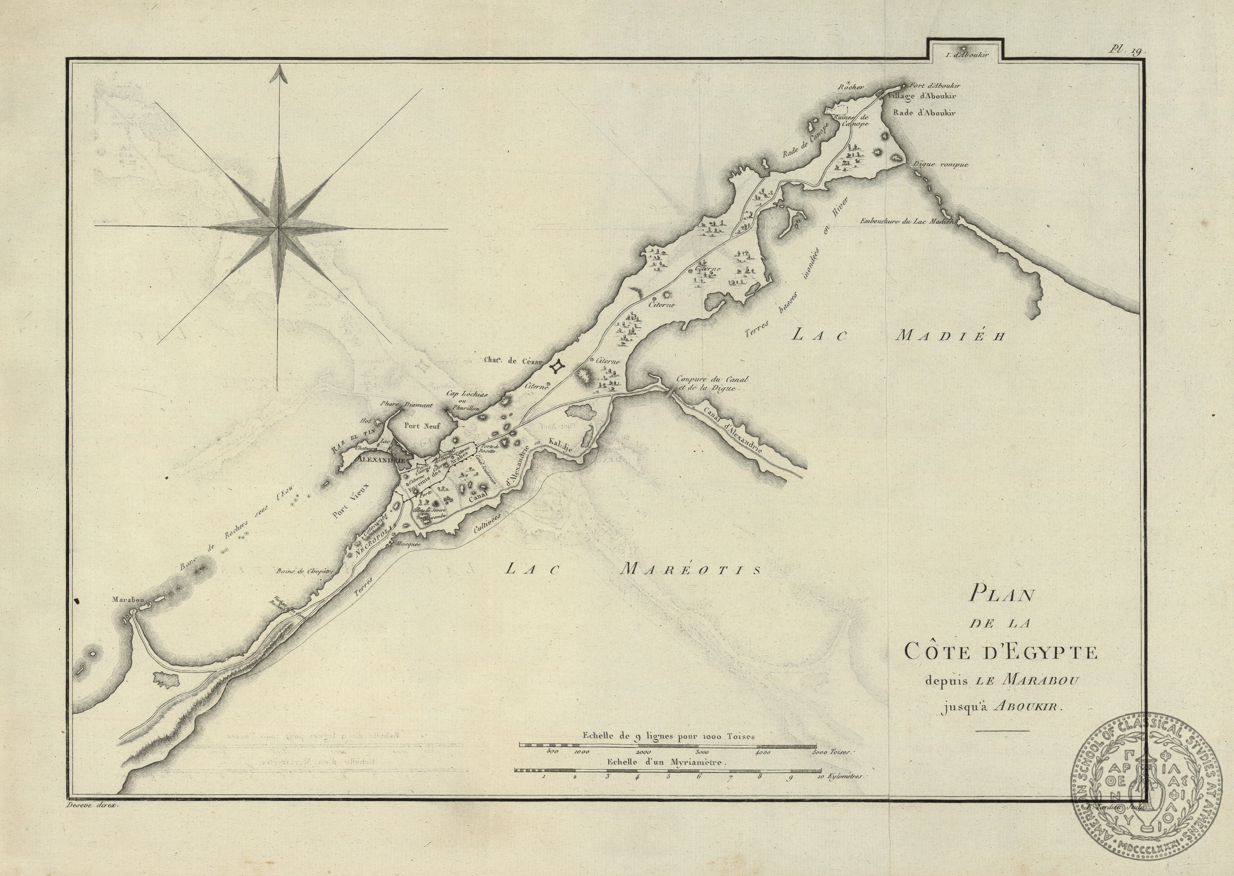
Plan de la Cote d' Egypte depuis le Marabou jusqu' a Aboukir
B. Tardieu
Africa -- Egypt -- part of Egypt
Call Number:
GT 1001.21 Bq
[1804]
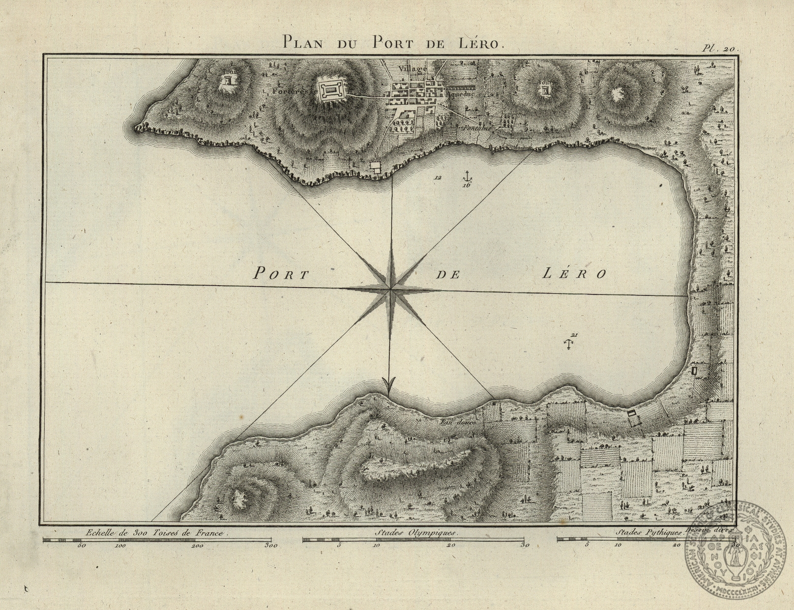
Plan du Port de Lero
Deseve
Europe -- The Balkans -- Greece -- Dodecanese -- Leros -- port of Leros
Call Number:
GT 1001.21 Bq
[1804]
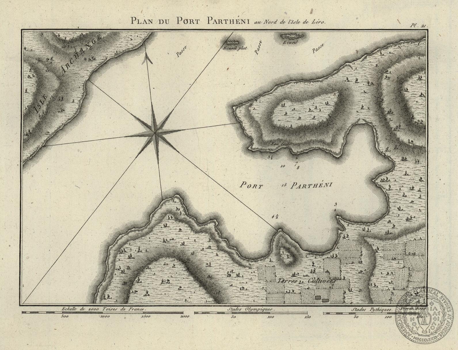
Plan du Port Partheni au nord de l' Isle de Lero
Deseve
Europe -- The Balkans -- Greece -- Dodecanese -- Leros -- port of Partheni
Call Number:
GT 1001.21 Bq
[1804]
Carte de la Syrie, de la Mesopotamie et d' une partie de la Perse pour le Voyage d' Olivier Membre de l' Institut Nationale de France
B. Tardieu
Asia -- Middle East
Asia -- Iran, Irak
Call Number:
GT 1001.21 Bq
[1804]
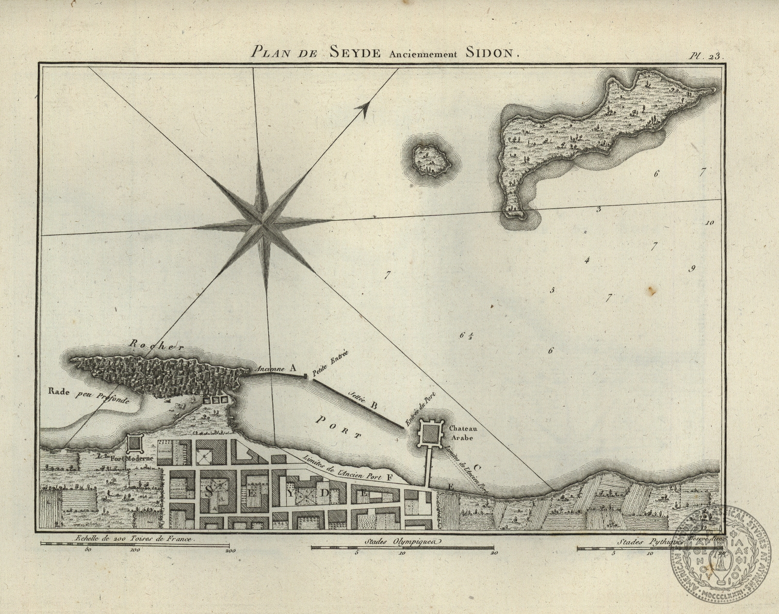
Plan de Seyde anciennement Sidon
Deseve
Asia -- Middle East -- Syria -- plan of the city of Sidon
Call Number:
GT 1001.21 Bq
[1804]
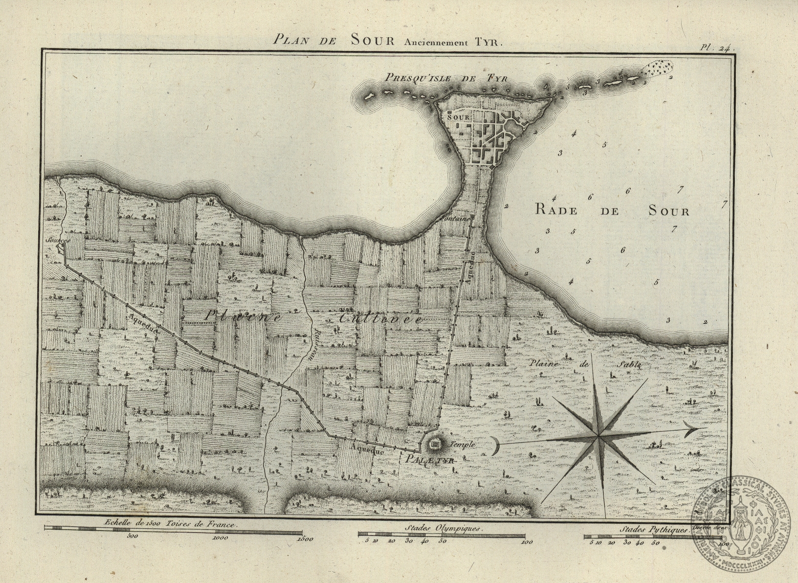
Plan de Sour anciennement Tyr
Deseve
Asia -- Middle East -- Syria -- plan of the city of Tyros
Call Number:
GT 1001.21 Bq
[1805]
Carte de l'Isle de Corfou et du territoire de Butrinto
Europe -- The Balkans -- Greece -- Corfu
Call Number:
HG 109.1 B 431 B
A map descriptive of the author's route from Constantinople to Jaffa; from thence with the Ottoman Army to Grand Cairo; and his return to Constantinople
Author:
J. Russell
Date:
[1803]
Geographic Coverage:
Asia -- Turkey, Middle East
Africa -- northern Egypt
Call Number:
GT 712
Skizze der Geographie von Troad
Author:
Champion
Date:
[1804]
Geographic Coverage:
Asia -- Turkey -- region of Troy
Call Number:
GT 709.1
Carte de la Basse Egypt
Author:
B. Tardieu
Date:
[1804]
Geographic Coverage:
Africa -- Egypt
Call Number:
GT 1001.21 Bq
Plan de la Cote d' Egypte depuis le Marabou jusqu' a Aboukir
Author:
B. Tardieu
Date:
[1804]
Geographic Coverage:
Africa -- Egypt -- part of Egypt
Call Number:
GT 1001.21 Bq
Plan du Port de Lero
Author:
Deseve
Date:
[1804]
Geographic Coverage:
Europe -- The Balkans -- Greece -- Dodecanese -- Leros -- port of Leros
Call Number:
GT 1001.21 Bq
Plan du Port Partheni au nord de l' Isle de Lero
Author:
Deseve
Date:
[1804]
Geographic Coverage:
Europe -- The Balkans -- Greece -- Dodecanese -- Leros -- port of Partheni
Call Number:
GT 1001.21 Bq
Carte de la Syrie, de la Mesopotamie et d' une partie de la Perse pour le Voyage d' Olivier Membre de l' Institut Nationale de France
Author:
B. Tardieu
Date:
[1804]
Geographic Coverage:
Asia -- Middle East
Asia -- Iran, Irak
Call Number:
GT 1001.21 Bq
Plan de Seyde anciennement Sidon
Author:
Deseve
Date:
[1804]
Geographic Coverage:
Asia -- Middle East -- Syria -- plan of the city of Sidon
Call Number:
GT 1001.21 Bq
Plan de Sour anciennement Tyr
Author:
Deseve
Date:
[1804]
Geographic Coverage:
Asia -- Middle East -- Syria -- plan of the city of Tyros
Call Number:
GT 1001.21 Bq
Carte de l'Isle de Corfou et du territoire de Butrinto
Date:
[1805]
Geographic Coverage:
Europe -- The Balkans -- Greece -- Corfu
A map descriptive of the author's route from Constantinople to Jaffa; from thence with the Ottoman Army to Grand Cairo; and his return to Constantinople
J. Russell
Asia -- Turkey, Middle East
Africa -- northern Egypt
Call Number:
GT 712
[1804]
Skizze der Geographie von Troad
Champion
Asia -- Turkey -- region of Troy
Call Number:
GT 709.1
[1804]
Carte de la Basse Egypt
B. Tardieu
Africa -- Egypt
Call Number:
GT 1001.21 Bq
[1804]
Plan de la Cote d' Egypte depuis le Marabou jusqu' a Aboukir
B. Tardieu
Africa -- Egypt -- part of Egypt
Call Number:
GT 1001.21 Bq
[1804]
Plan du Port de Lero
Deseve
Europe -- The Balkans -- Greece -- Dodecanese -- Leros -- port of Leros
Call Number:
GT 1001.21 Bq
[1804]
Plan du Port Partheni au nord de l' Isle de Lero
Deseve
Europe -- The Balkans -- Greece -- Dodecanese -- Leros -- port of Partheni
Call Number:
GT 1001.21 Bq
[1804]
Carte de la Syrie, de la Mesopotamie et d' une partie de la Perse pour le Voyage d' Olivier Membre de l' Institut Nationale de France
B. Tardieu
Asia -- Middle East
Asia -- Iran, Irak
Call Number:
GT 1001.21 Bq
[1804]
Plan de Seyde anciennement Sidon
Deseve
Asia -- Middle East -- Syria -- plan of the city of Sidon
Call Number:
GT 1001.21 Bq
[1804]
Plan de Sour anciennement Tyr
Deseve
Asia -- Middle East -- Syria -- plan of the city of Tyros
Call Number:
GT 1001.21 Bq
[1805]
Carte de l'Isle de Corfou et du territoire de Butrinto
Europe -- The Balkans -- Greece -- Corfu
Call Number:
HG 109.1 B 431 B
A map descriptive of the author's route from Constantinople to Jaffa; from thence with the Ottoman Army to Grand Cairo; and his return to Constantinople
Author:
J. Russell
Date:
[1803]
Geographic Coverage:
Asia -- Turkey, Middle East
Africa -- northern Egypt
Call Number:
GT 712
Skizze der Geographie von Troad
Author:
Champion
Date:
[1804]
Geographic Coverage:
Asia -- Turkey -- region of Troy
Call Number:
GT 709.1
Carte de la Basse Egypt
Author:
B. Tardieu
Date:
[1804]
Geographic Coverage:
Africa -- Egypt
Call Number:
GT 1001.21 Bq
Plan de la Cote d' Egypte depuis le Marabou jusqu' a Aboukir
Author:
B. Tardieu
Date:
[1804]
Geographic Coverage:
Africa -- Egypt -- part of Egypt
Call Number:
GT 1001.21 Bq
Plan du Port de Lero
Author:
Deseve
Date:
[1804]
Geographic Coverage:
Europe -- The Balkans -- Greece -- Dodecanese -- Leros -- port of Leros
Call Number:
GT 1001.21 Bq
Plan du Port Partheni au nord de l' Isle de Lero
Author:
Deseve
Date:
[1804]
Geographic Coverage:
Europe -- The Balkans -- Greece -- Dodecanese -- Leros -- port of Partheni
Call Number:
GT 1001.21 Bq
Carte de la Syrie, de la Mesopotamie et d' une partie de la Perse pour le Voyage d' Olivier Membre de l' Institut Nationale de France
Author:
B. Tardieu
Date:
[1804]
Geographic Coverage:
Asia -- Middle East
Asia -- Iran, Irak
Call Number:
GT 1001.21 Bq
Plan de Seyde anciennement Sidon
Author:
Deseve
Date:
[1804]
Geographic Coverage:
Asia -- Middle East -- Syria -- plan of the city of Sidon
Call Number:
GT 1001.21 Bq
Plan de Sour anciennement Tyr
Author:
Deseve
Date:
[1804]
Geographic Coverage:
Asia -- Middle East -- Syria -- plan of the city of Tyros
Call Number:
GT 1001.21 Bq
Carte de l'Isle de Corfou et du territoire de Butrinto
Date:
[1805]
Geographic Coverage:
Europe -- The Balkans -- Greece -- Corfu