

PH 29.v.3
In Scrapbook
Walachia Servia, Bulgaria, Romania
This map is based on Mercator's cartographic prototype but it was edited and published by Willem [Guglielmus] Blaeu. Coloured in outline.
leaf 36
[ca.1635]
Mercator
Gerard
Blaeu
Amsterdam
Publisher
1 map on 1 sheet
38.3 x 50.5 cms.
Europe-Balkans-Bulgaria, Romania, Thrace to the Bosphorus, and the area north of Thessaloniki.
ASCSA-G
2651

PH 29.v.3
In Scrapbook
Slavonia, Croatia, Bosnia cum Dalmatiae parte.
The arms of Venice, Austria and Turkey are included on the map surface.
leaf 37
[ca.1635]
Mercator
Gerard
Blaeu
Amsterdam
Publisher
1 map on 1 sheet
38.2 x 49.5 cms.
Europe-Balkans-Croatia, Europe-Balkans- Bosnia
ASCSA-G
2652

PH 29.v.3
In Scrapbook
Danubius, Fluvius Europae maximae, a fontibus ad Ostia cum omnibus fluminibus, ab utroque latere, in illum defluentibus.
The map is illustrated with engraved anthropomorphic figures of rivers, and it contains an elaborate cartouche with a pair of male and female figures depicting Austria and Turkey. It comes from an atlas with text on the verso of the map in German. The ma
leaf 38
[ca.1680?]
```
41 x 97 cms.
Europe-Eastern Germany Europe-Balkans Black Sea
ASCSA-G
2653

PH 29.v.3
In Scrapbook
Cyprus Insula / Candia, olim Creta.
This map sheet contains two maps engraved on one plate. Occasionally the maps are cut apart and sold separately; the titles occur on the relative maps. These two maps are well known and have been described in many catalogues.
leaf 39
[1573]
[Ortelius]
[Abraham]
Ortelius
[Antwerp]
Publisher
2 maps on 1 sheet
36.5 x 43.5 cms (2 maps 1
Europe-Greece-Crete Asia-Cyprus
ASCSA-G
2654

PH 29.v.3
In Scrapbook
Carte de l'Empire Othoman consideree dans les Etats de cette puissance, et des Etats qui l'avoisine ou qui luy sont tributaires,ainsi que deux petites cartes pour conduire a l'histoire universelle, et en particuliere a l'histoire d' Alexandre le Grand…
This map contains two insets, one of which is entitled 'Carte de la Grece', the other 'Carte pour conduire a l' histoire universelle
leaf 40
[17--?]
1 map on 1 sheet
46.5 x 90 cms.
Europe-Ottoman Empire Asia-Ottoman Empire Africa-Ottoman Empire
ASCSA-G
2655
PH 29.v.3
In Scrapbook
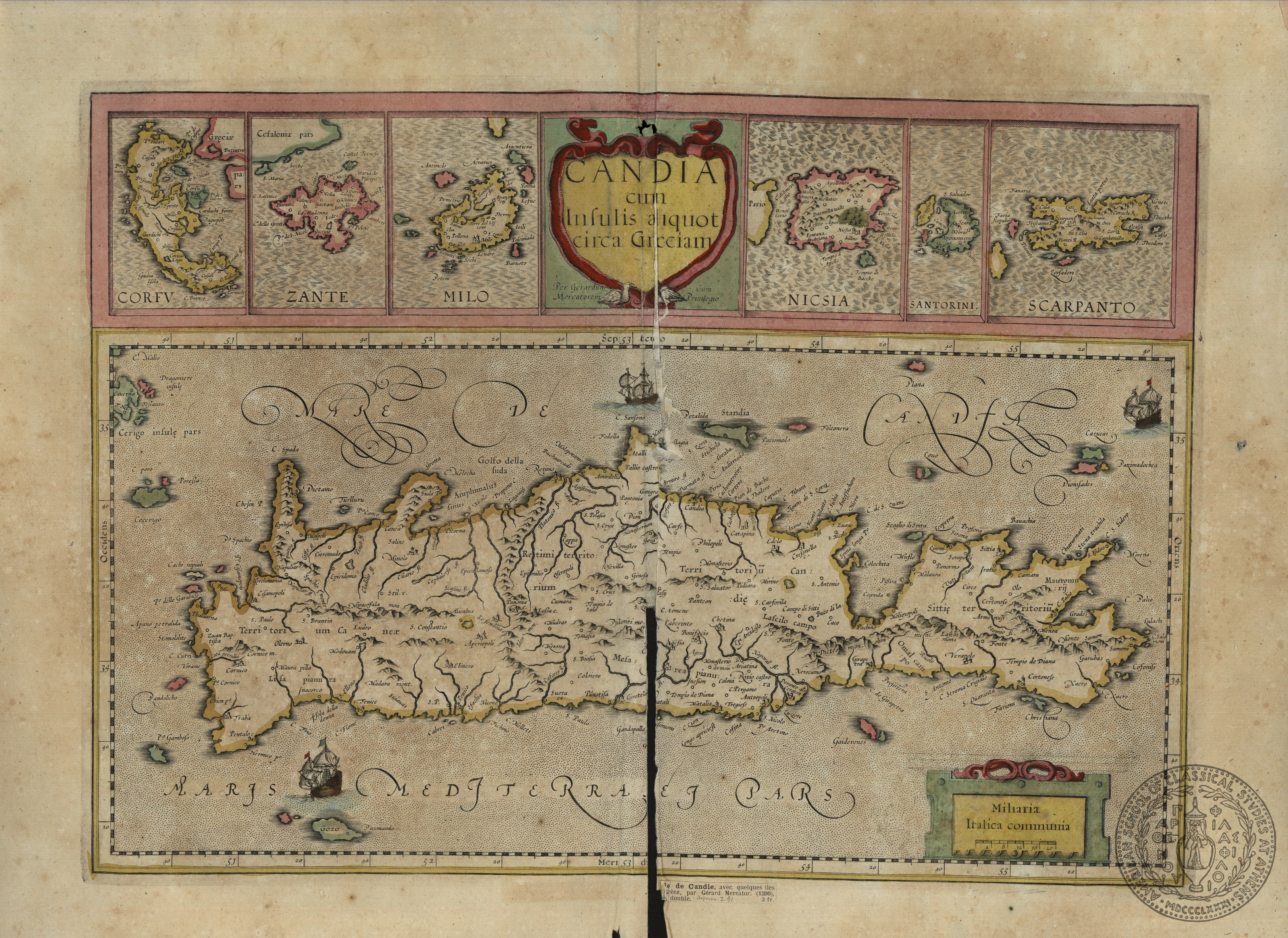
Candia cum Insulis aliquot circa Graeciam // Corfu/ /Zante/ Milo/ Nicsia/ Santorini/ Scarpanto
This map is composed of 7 inset maps. The main map is of Crete, surrounded by smaller insets of Corfu, Zakynthos, Milos, Naxos, Santorini, Carpathos. This map was first produced by Mercator in 1590 and was published in successive editions of his atlas up
leaf 41
[ca.1600]
Mercator
Gerard
r
6 maps on 1 sheet
34 x 47.5 cms.
Europe-Greece-Corfu Europe-Greece-Zakynthos Europe-Greece-Milos Europe-Greece-Naxos Europe-Greece, Santorini Europe-Greece-Carpathos
ASCSA-G
2656

PH 29.v.3
In Scrapbook
Candia, olim Creta
This map has been attributed to Willem Blaeu with the date 1642 on the map in manuscript.
leaf 44
[1642]
[Willem Blaeu]
[Amsterdam]
Publisher
1 map on 1 sheet
38 x 52.5 cms.
Europe-Greece-Crete
ASCSA-G
2657

PH 29.v.3
In Scrapbook
Candia olim Creta
This map was first published by Janssonius in his Atlas Novus of 1638, with many subsequent editions up to 1661, in many languages.
leaf 45
[1638]
Janssonius
Johannes
Jan Janssonius
Amsterdam
Publisher
1 map on 1 sheet
38 x 52.8 cms.
Europe-Greece-Crete
ASCSA-G
2658
PH 29.v.2
In Scrapbook
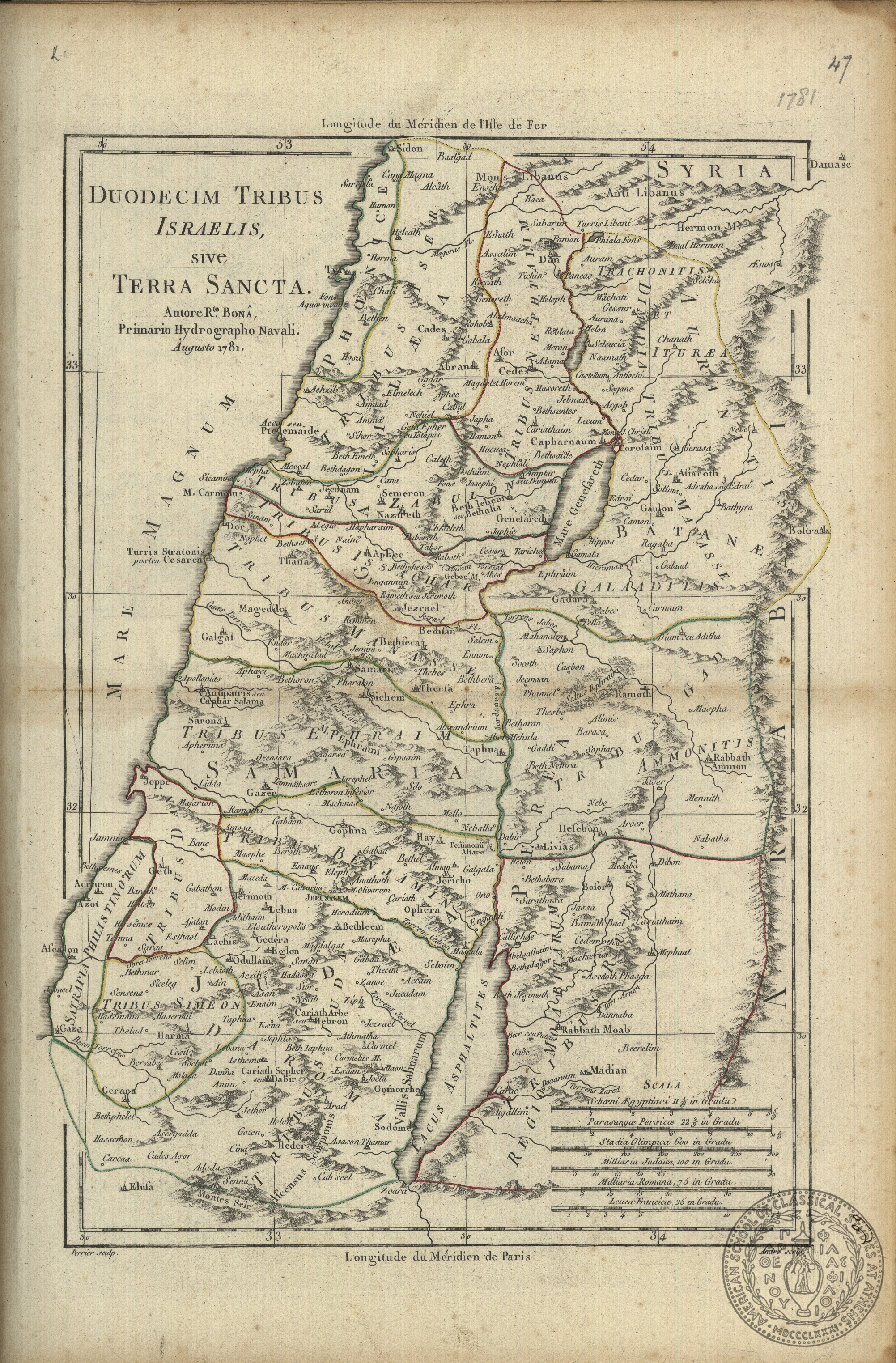
Duodecim Tribus Israelis sive Terra Sancta.
Bona's name is also transcribed as Bonne.
leaf 47
1781
Bona [Bonne]
Roberto
Engraver
1 map on 1 sheet
31.7 x 21.5 cms.
Asia-Middle East-Palestine
ASCSA-G
2753
PH 29.v.2
In Scrapbook
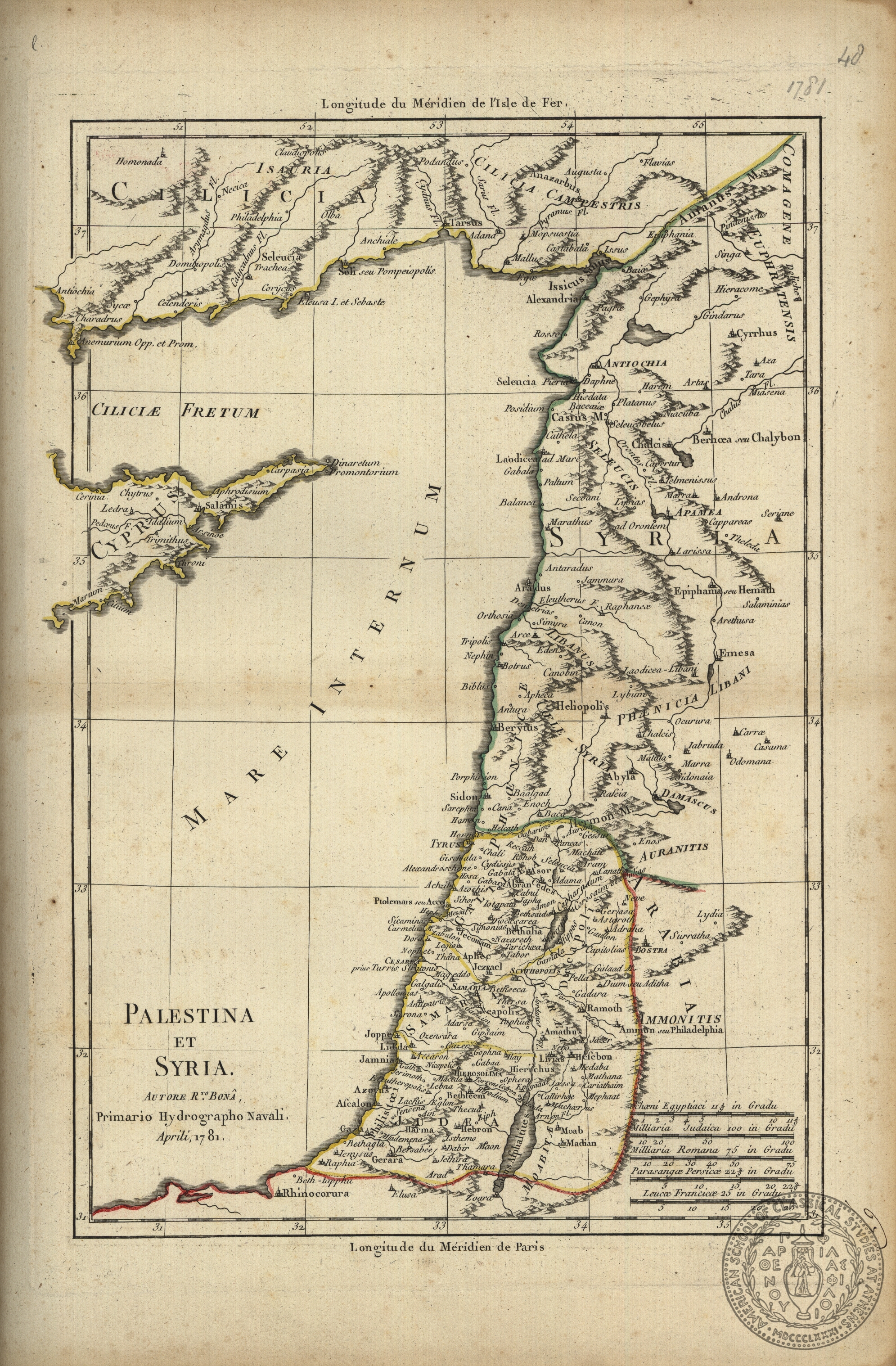
Palestina et Syria.
The French version of Bona's name is Bonne.
leaf 48
1781
Bona [Bonne]
Roberto
1 map on 1 sheet
32 x 21.5 cms.
Asia-Middle East-Syria Asia-Middle East-Cilicia Asia-Middle East-Palestine Asia-Cyprus-eastern half
ASCSA-G
2754
PH 29.v.2
In Scrapbook
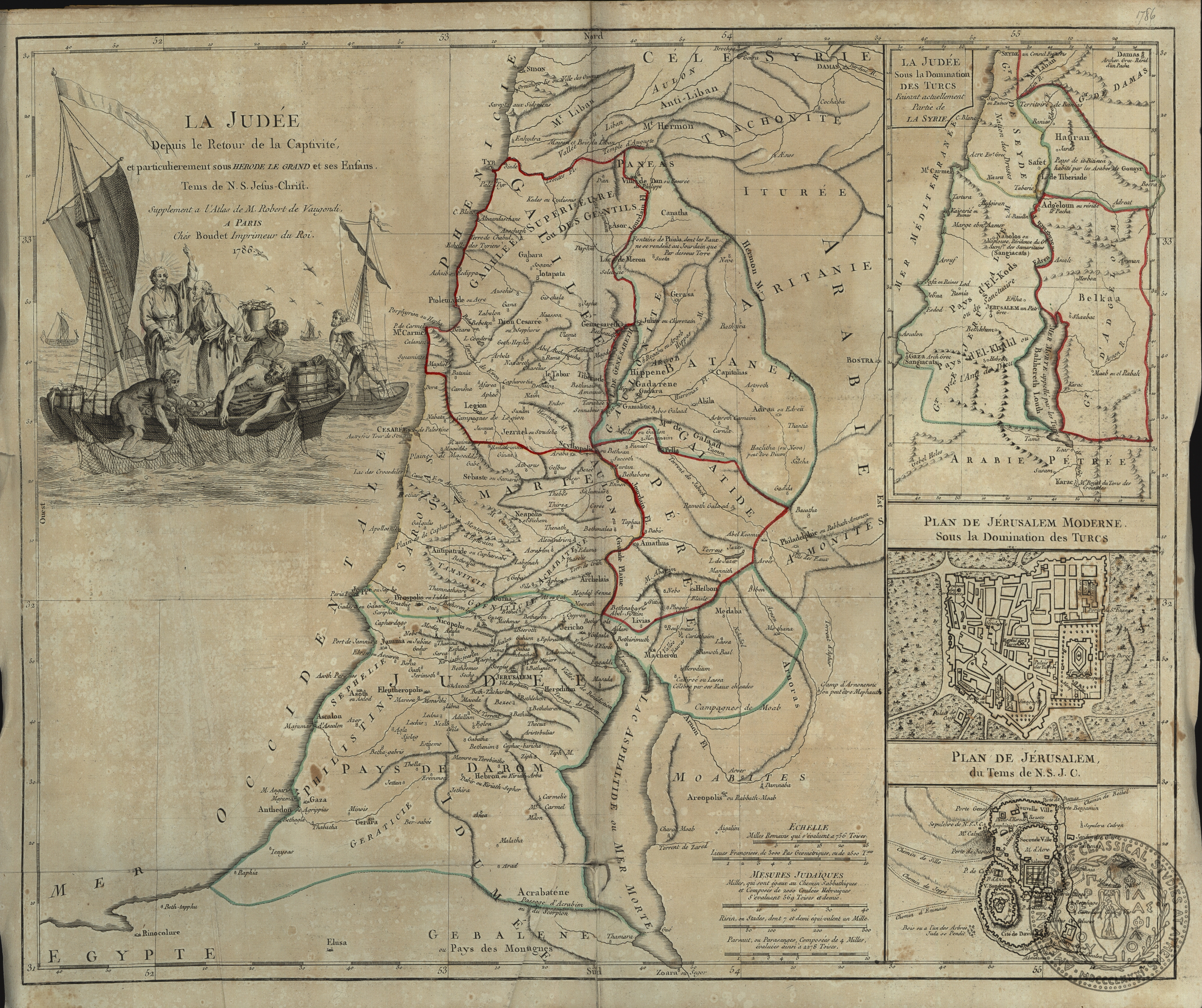
La Judee depuis la retour de la Captivite, … tenis de N. S. Jesus-Christ.
With three insets: "La Judee sous la Domination des Turcs…", "Plan de Jerusalem moderne sous la Domination des Turcs", "Plan de Jerusalem du Tems de N.S.J.C.".
leaf 49
1786
Robert de Vaugondy
Boudet
Paris
Publisher
1 map on 1 sheet
47 x 57.5 cms.
Asia-Middle East-Palestine
ASCSA-G
2755
PH 29.v.2
In Scrapbook
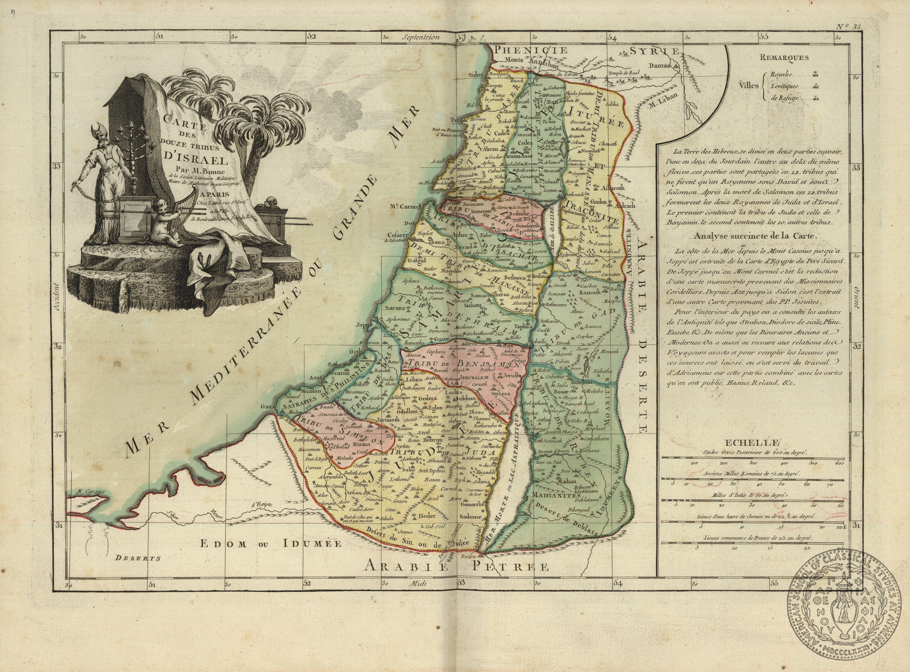
Carte des Douze Tribus d'Israel
Bonne is also known as Bona.
leaf 50
[17--]
Bonne
Lattre
Paris
Publisher
1 map on 1 sheet
30.7 x 44 cms.
Asia-Middle East-Palestine
ASCSA-G
2756

PH 29.v.2
In Scrapbook
Le Dodeci Tribu d' Israele: Terra di Canaan ou Terra Promessa…
This map was probably also engraved by Zatta.
leaf 51
1785
Antonio Zatta e Figli
Venice
Publisher
1 map on 1 sheet
31 x 41 cms.
Asia- Middle East-Palestine
ASCSA-G
2757
PH 29.v.2
In Scrapbook
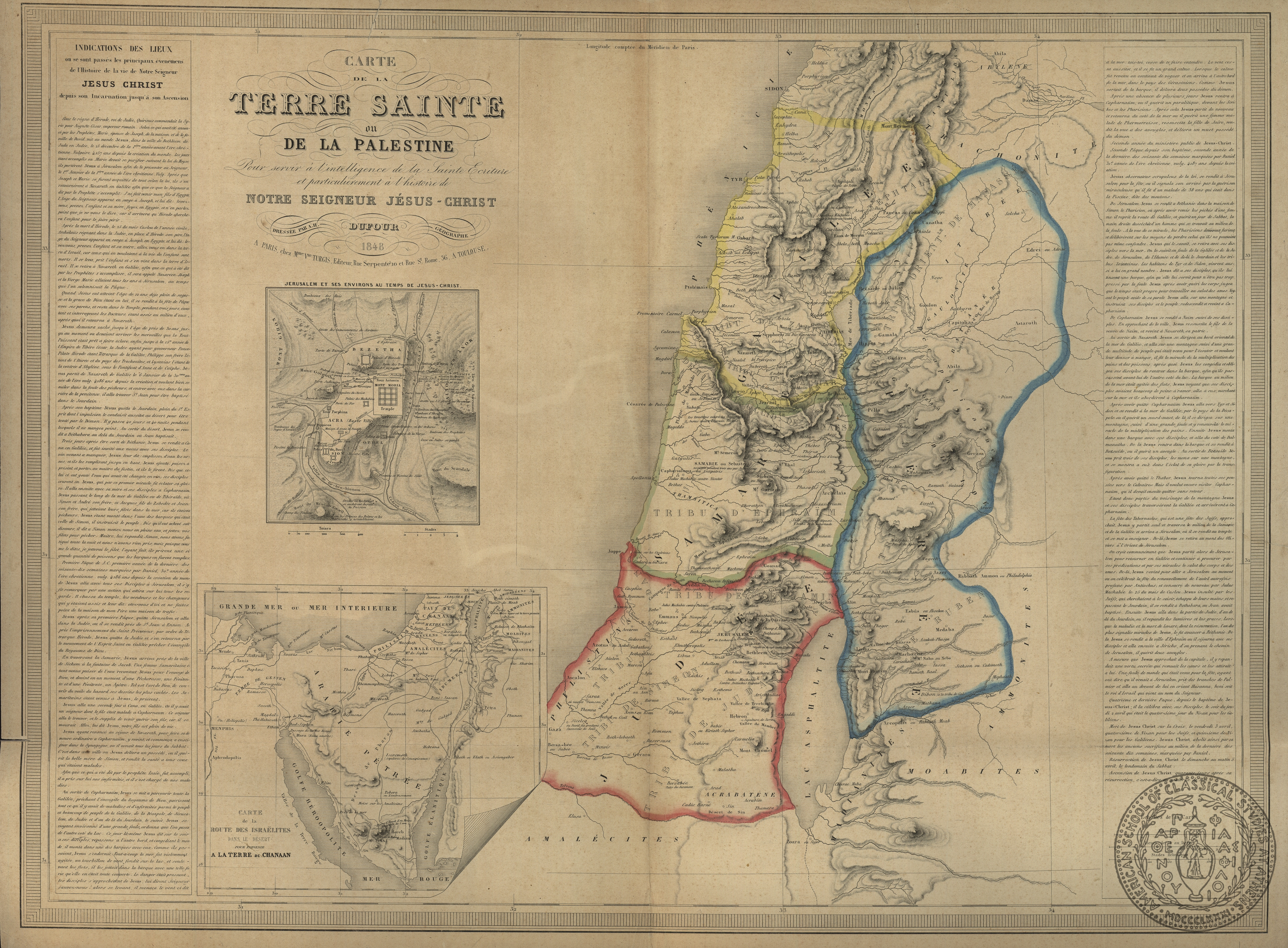
Carte de la Terre Sainte ou de la Palestine…
This map has two insets: "Jerusalem", and "Carte de la Route des Israelites dans le desert". It has extensive text on both the right and left hand margins.
leaf 52
1848
Dufour
A.
Mme. Vueve Turgis
Paris
Publisher
1 map on 1 sheet
53.5 x 73 cms.
Asia-Middle East-Palestine
ASCSA-G
2758
PH 45
In Scrapbook
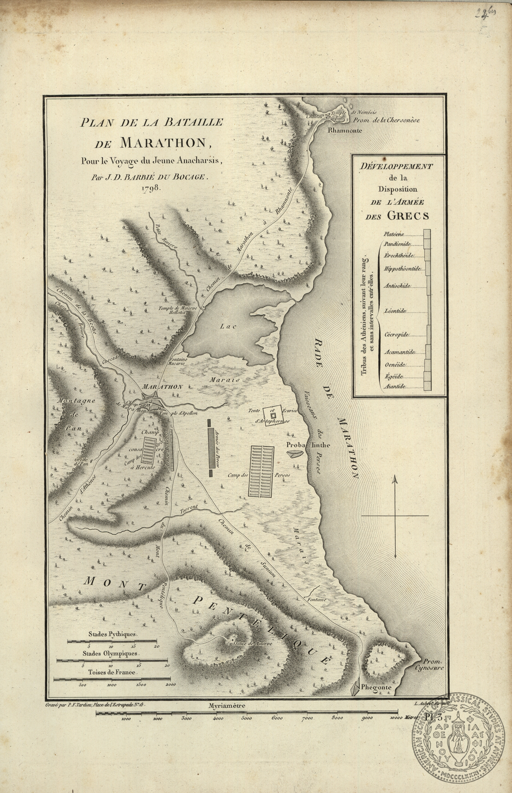
Plan de la Bataille de Marathon…
This map of the plain of Marathon comes from Didot's edition of Barthelemy's "Voyage du Jeune Anacharsis", 1799.
leaf 24bis
1798-99
Barbie du Bocage
J.
Engraver
[Didot]
Paris
Publisher
1 map on 1 sheet
32.5 x 21.8 cms.
Europe-Greece-Marathon
ASCSA-G
2759
PH 45
In Scrapbook
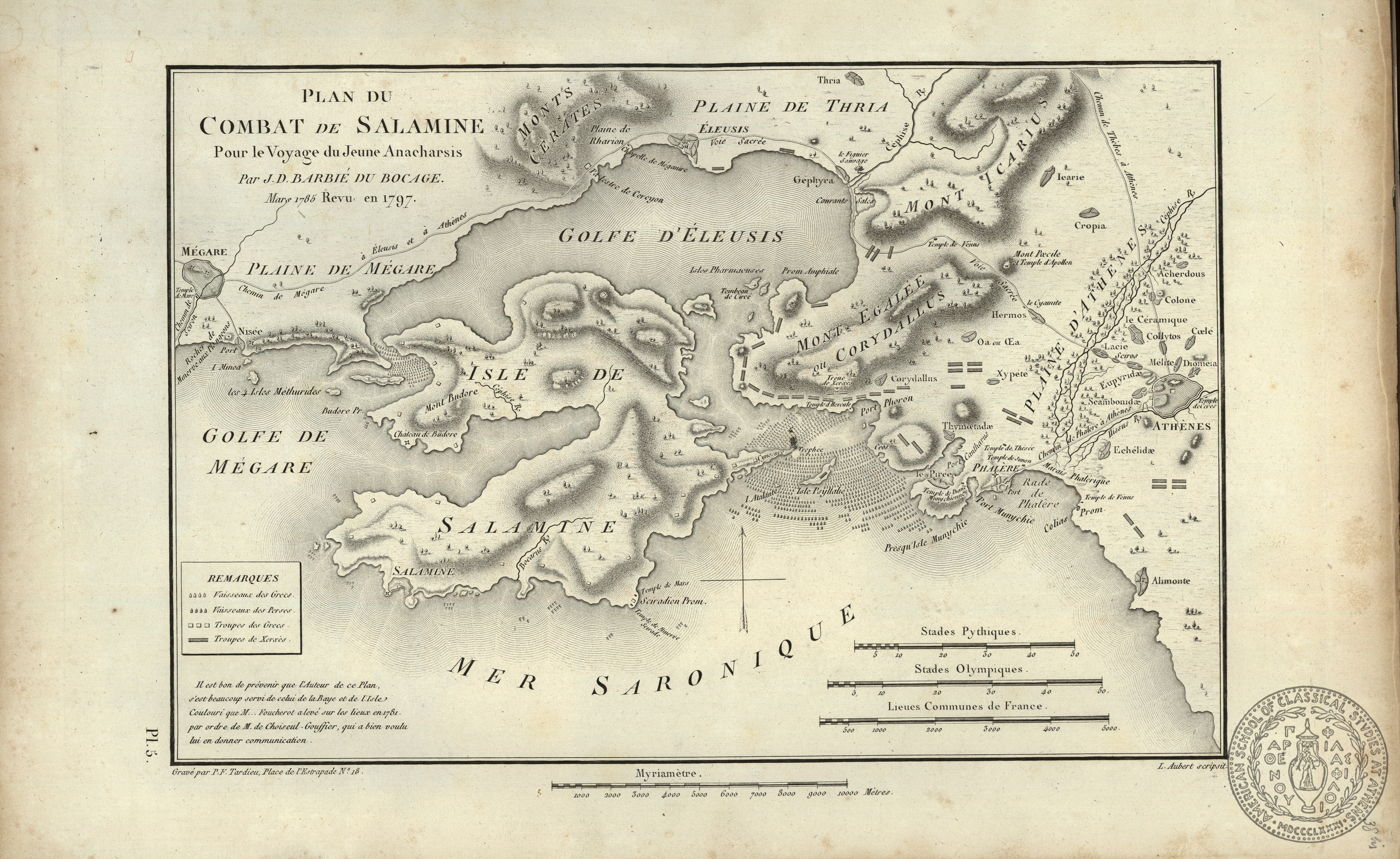
Plan du Combat de Salamine…
Published in Didot's edition of Barthelemy's "Voyage du Jeune Anacharsis", 1799.
leaf 38bis
1798-99
Barbie du Bocage
J.
Engraver
[Didot]
[Paris]
Publisher
1 map on 1 sheet
21.9 x 33 cms.
Europe-Greece-Salamina
ASCSA-G
2760
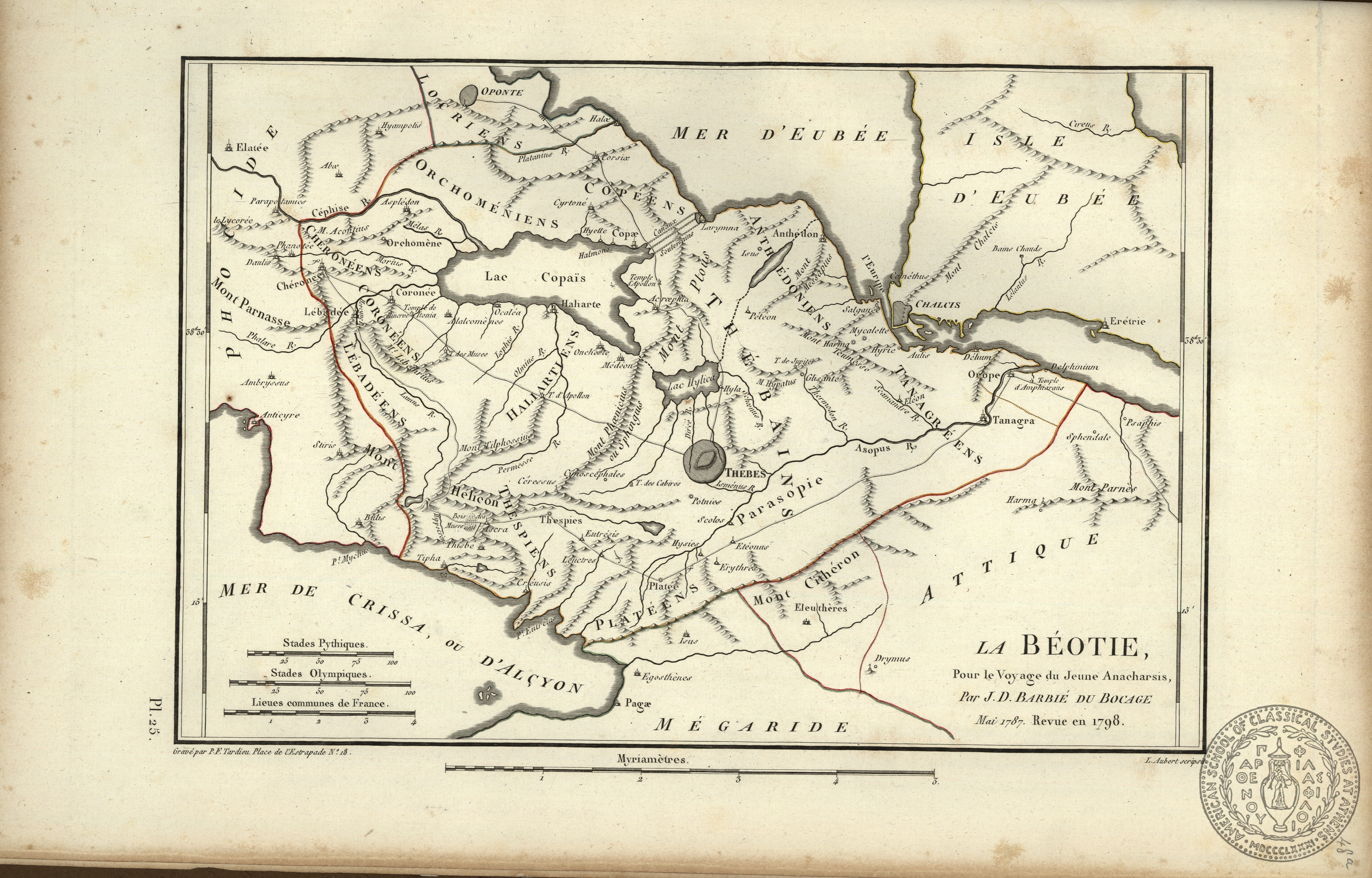
PH 45
In Scrapbook
La Beotie…
Published in Didot's edition of Barthelemy's "Voyage du Jeune Anacharsis, 1799. The map was first constructed by Barbie du Bocage in 1787.
leaf 48a
1798-99
Barbie du Bocage
J.
Engraver
[Didot]
[Paris]
Publisher
1 map on 1 sheet
21.7 x 32.5 cms.
Europe-Greece-Boeotia
ASCSA-G
2761
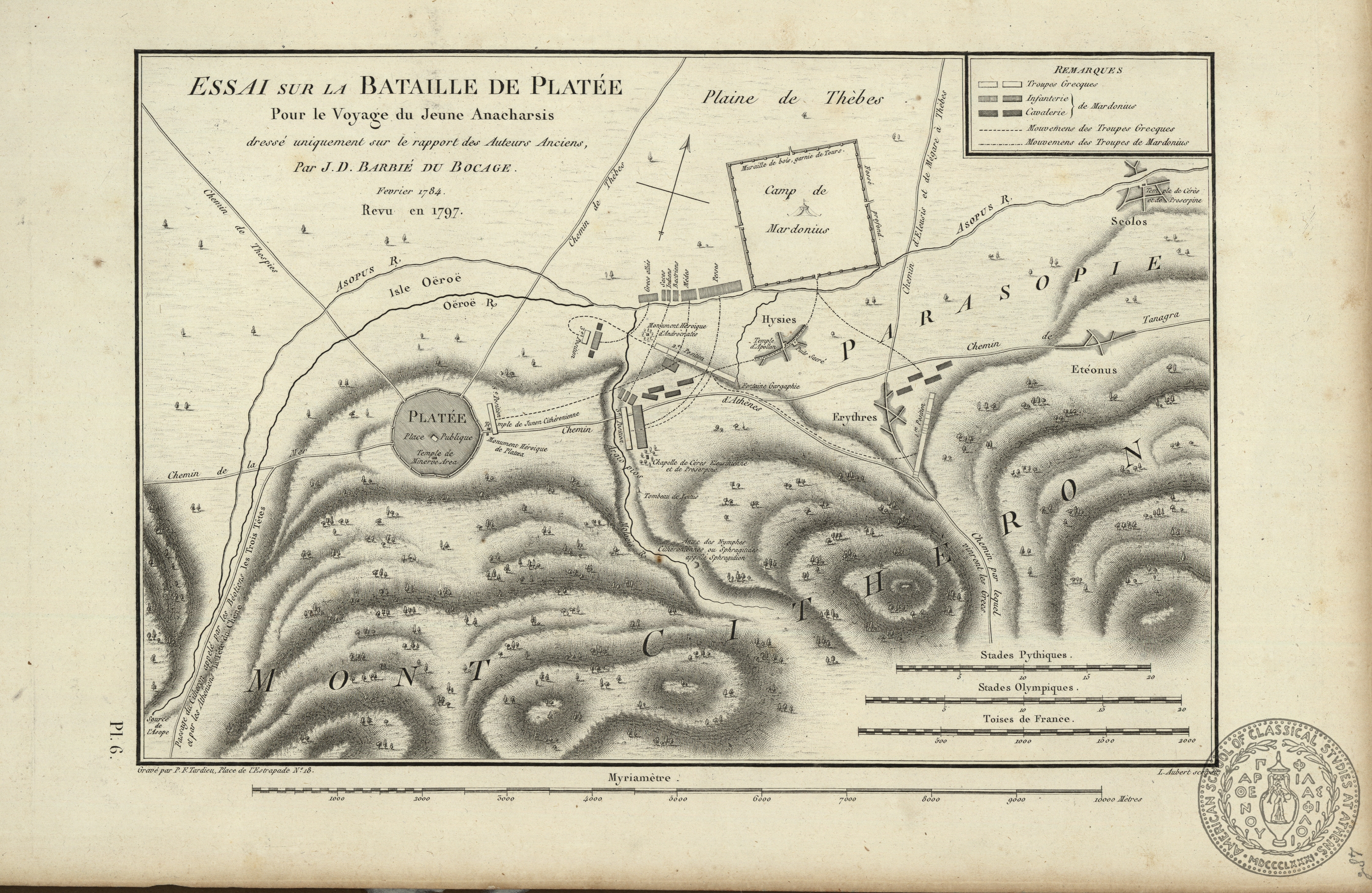
PH 45
In Scrapbook
Essai sur la Bataille de Platee…
Published in Didot's edition of Barthelemy's "Voyage du Jeune Anacharsis", 1798-99.
leaf 48b
[1798-99]
Barbie du Bocage
J.
Engraver
[Didot]
[Paris]
Publisher
1 map on 1 sheet
21.7 x 32.8 cms.
Europe-Greece-Plataea
ASCSA-G
2762
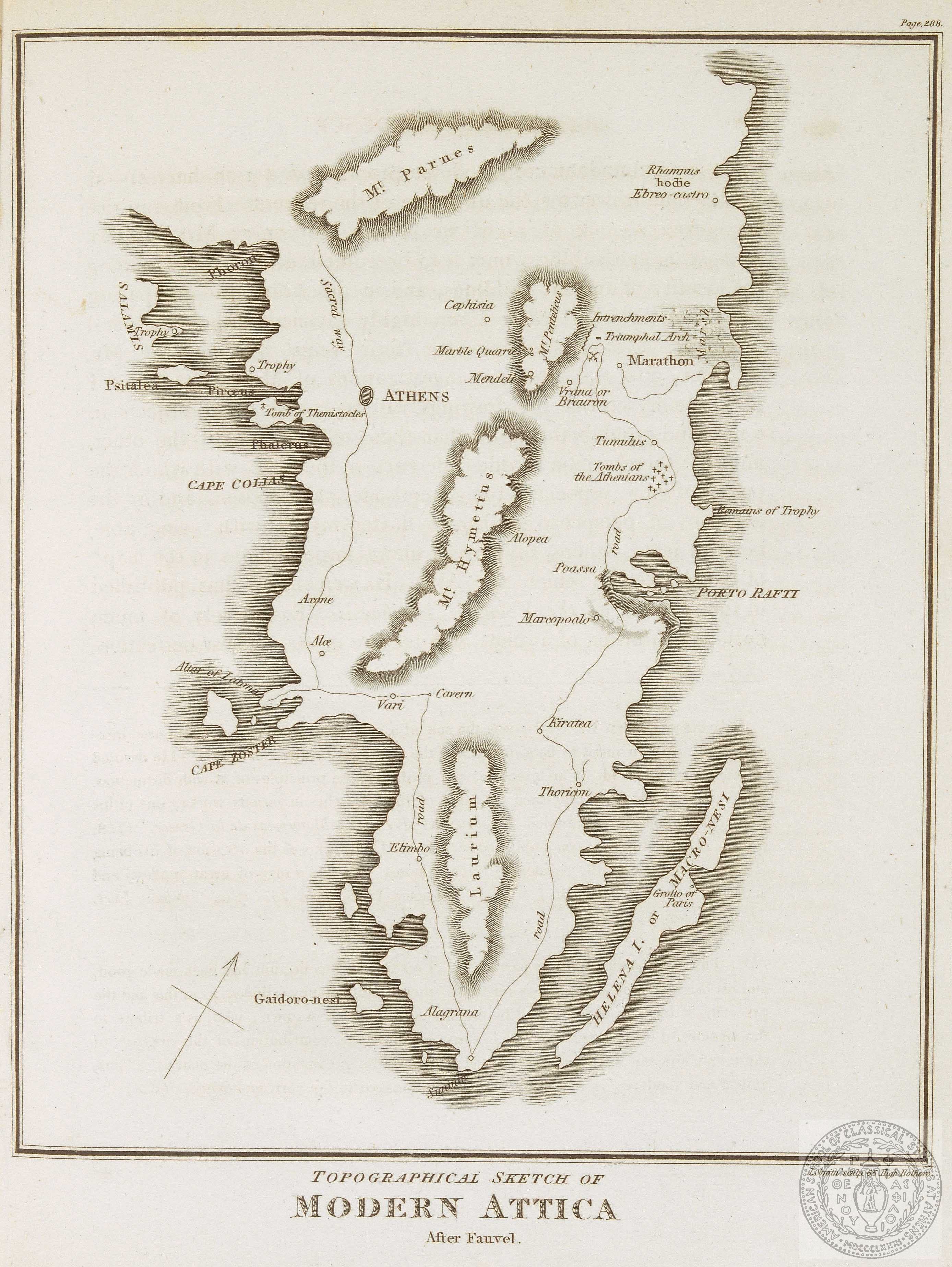
PH 45
In Scrapbook
Topographical Sketch of Modern Attica.
leaf 2
[18--]
Smith
J.
London
1 map on 1 sheet
22.3 x 18.4 cms.
Europe-Greece-Attica
ASCSA-G
2763

PH 45
In Scrapbook
Attica
This map of Attica was first published in Spon's "Voyage", Lyon, 1678. This copy has been attributed to the 1679 edition of Amsterdam by Gennadius, with a note in his hand.
leaf 2va
[1679?]
[Amsterdam?]
1 map on 1 sheet
12 x 14 cms.
Europe-Greece-Attica
ASCSA-G
2764
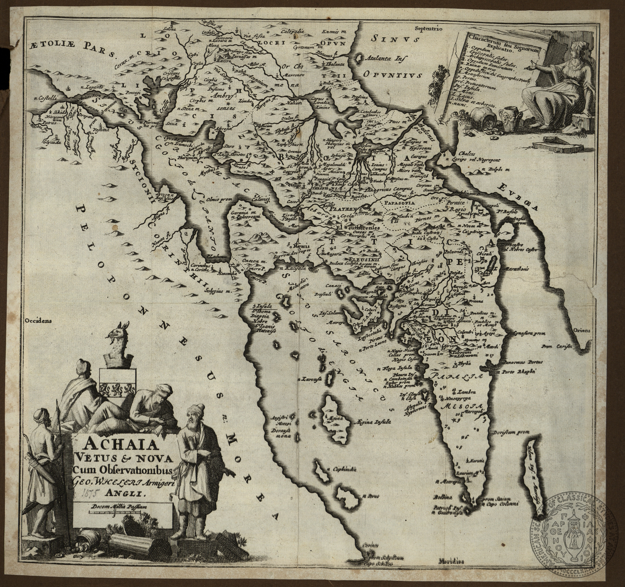
PH 45
In Scrapbook
Achaia vetus & nova cum observationibus Geo. Wheleri…
This map comes from the French edition of Wheler's Travels, Amsterdam, 1689. In the English edition the map is much larger.
leaf 2vb
[1689]
Wheler
G.
[Jean Wolters]
[Amsterdam]
Publisher
1 map on 1 sheet
24.7 x 25.7 cms.
Europe-Greece-Attica
ASCSA-G
2765
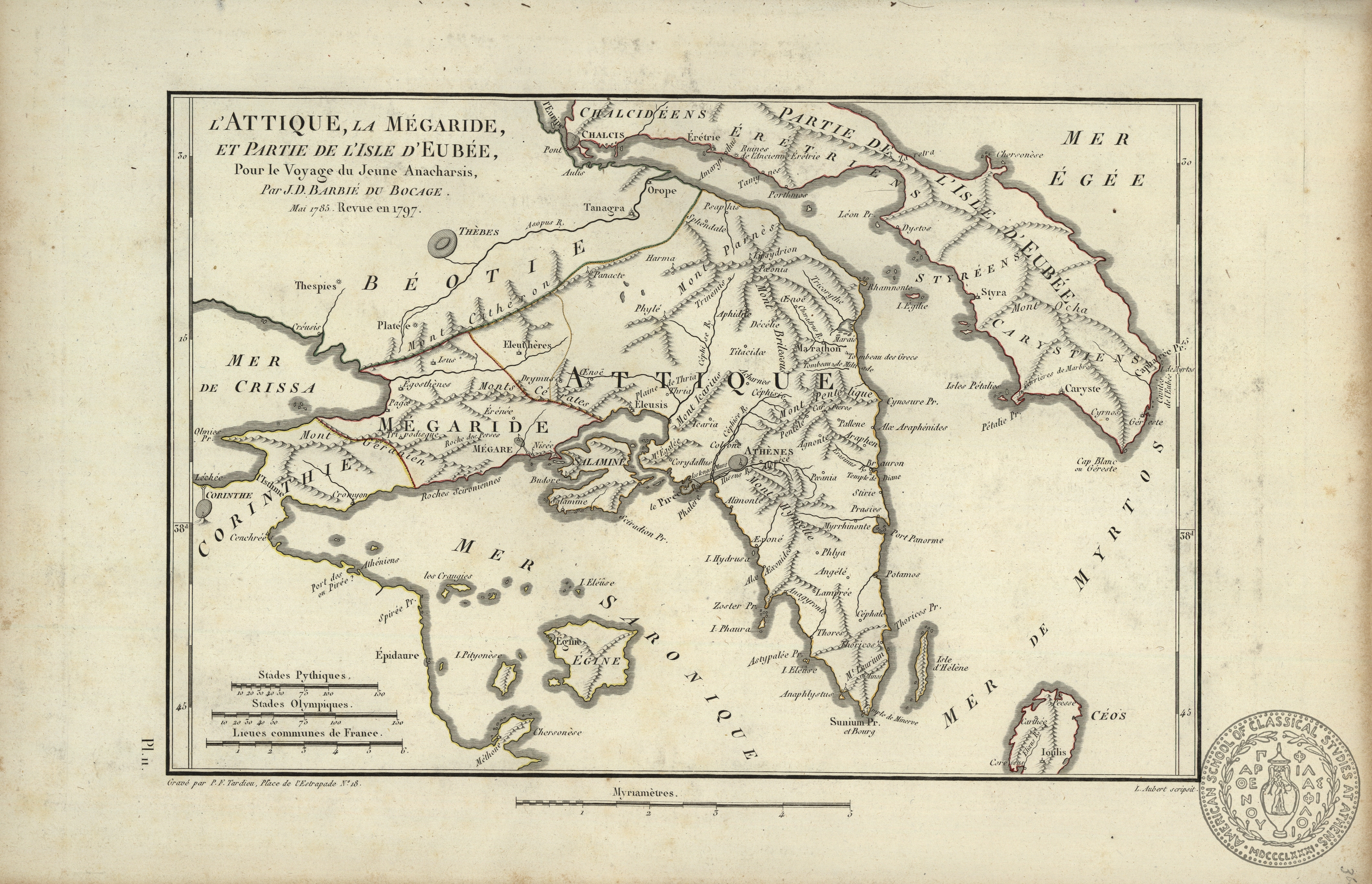
PH 45
In Scrapbook
L'Attique, la Megaride, et partie de l'Isle d'Eubee, pour le voyage du Jeune Anacharsis…
Published in Didot's edition of Barthelemy's "Voyage du Jeune Anacharsis", Paris, 1799.
leaf 3
1798-99
Barbie du Bocage
J.
Engraver
[Didot]
[Paris]
Publisher
1 map on 1 sheet
21.7 x 32.6 cms.
Europe-Greece-Attica
ASCSA-G
2766
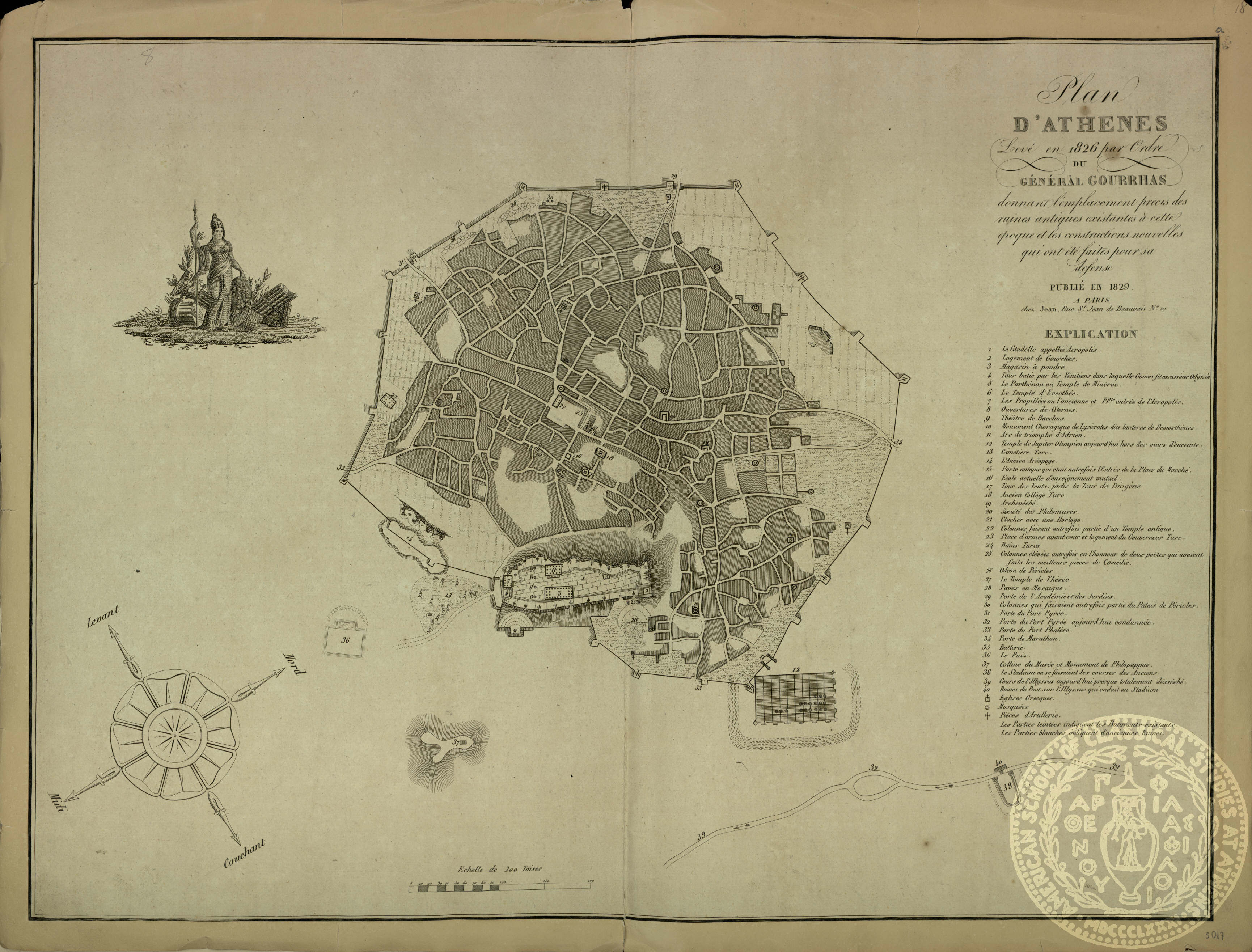
PH 40
In Scrapbook
Plan d' Athenes levee en 1826, par ordre du General Gourrhas par J. F. Bessan…
This is a photograph of the original map, to be found in Bessan's book "Souvenirs", Paris, 1835. There is an inset with vignettes of ancient buildings in Athens.
sheet [1] at leaf 2
[1835]
Bessan
J.
[Valognes]
1 map on 1 sheet
20.6 x 26.5 cms.
Europe-Greece-Athens
ASCSA-G
2767
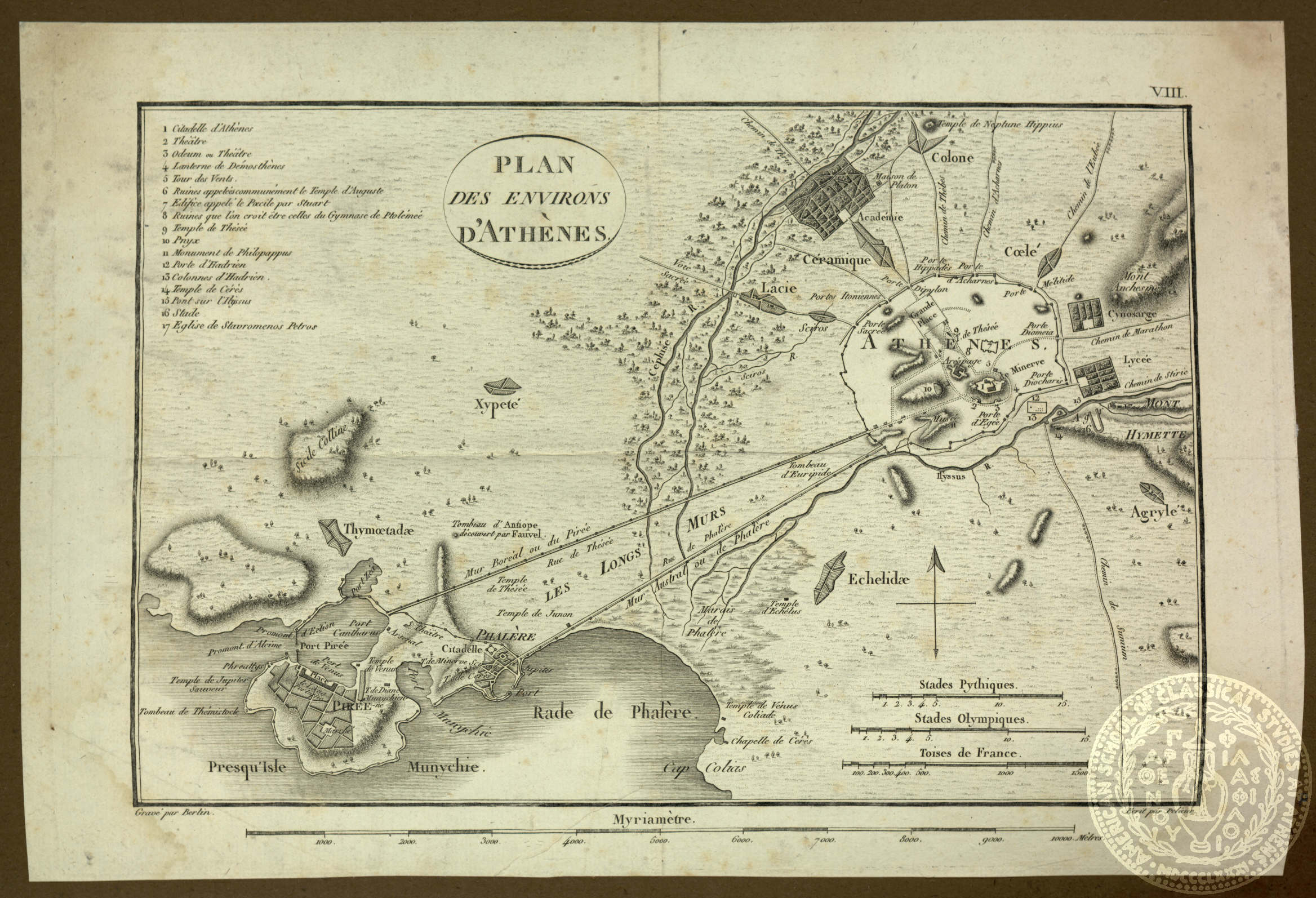
PH 40
In Scrapbook
Plan des Environs d' Athenes.
leaf 3
[18--]
Berlin
1 map on 1 sheet
21.3 x 32.4 cms.
Europe-Greece-Athens
ASCSA-G
2768
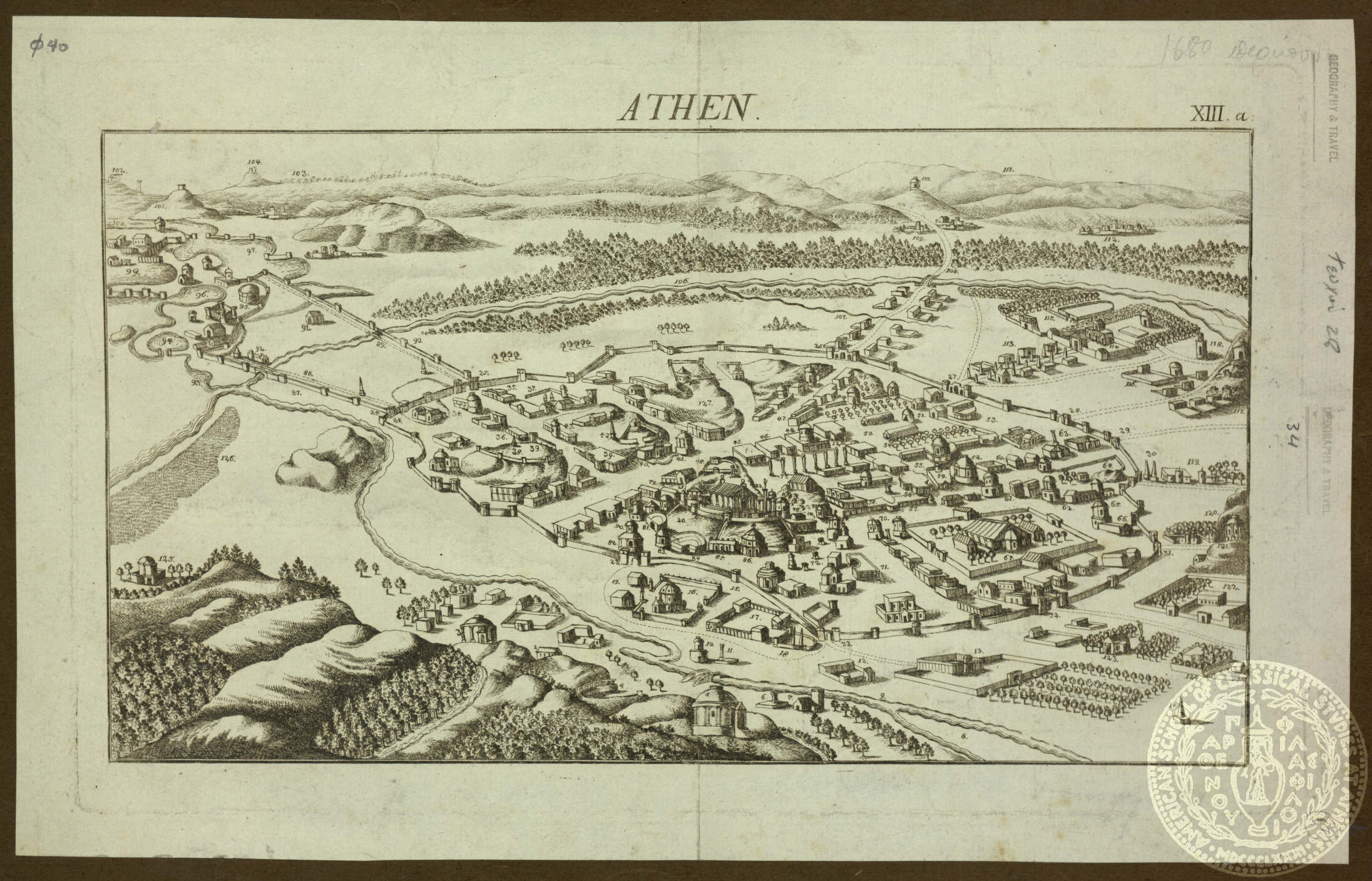
PH 40
In Scrapbook
Athen
There is no information on the map surface. A note in ms. attributes the date 'c.1680'. There is a printed reference at the upper margin: "XIII.a:".
leaf 4
[1680?]
1 map on 1 sheet
17.2 x 31 cms.
Europe-Greece-Athens
ASCSA-G
2769
PH 40
In Scrapbook
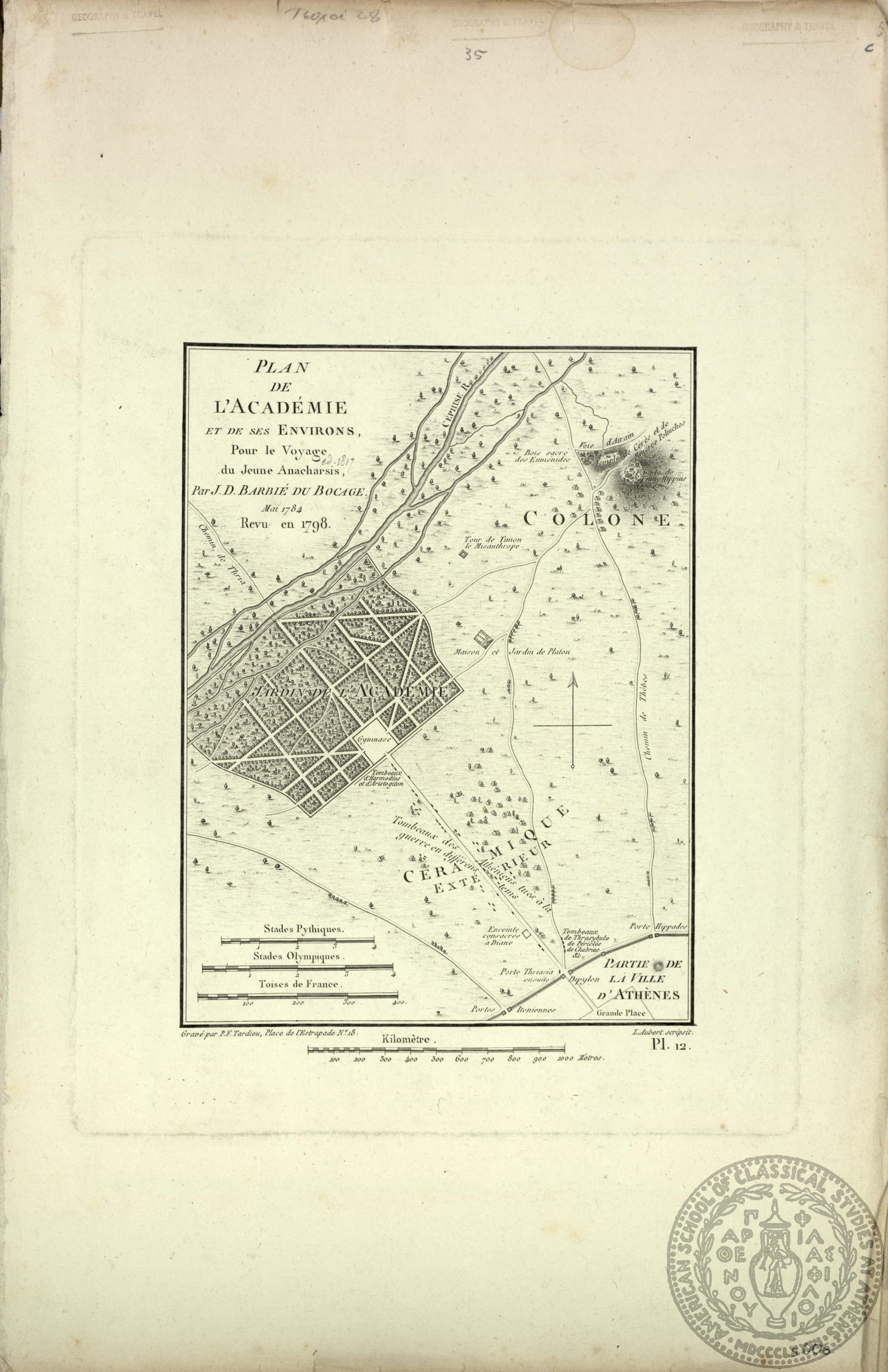
Plan de l' Academie et de ses Environs, pour le Voyage du Jeune Anacharsis…
This map was prepared for Didot's edition of Barthelemy's "Voyage du Jeune Anacharsis". This copy may have been published in another edition. It forms plate 12 in the edition from which it was removed. A note in Gennadius's hand states 'ed. 1817'. There i
sheet 2 (no. 35) at leaf
[1798-99]
Barbie du Bocage
J.
engraver of the lettering
[Didot?]
Paris
Publisher
1 map on 1 sheet
21.7 x 16.3 cms.
Europe-Greece-Athens
ASCSA-G
2770
PH 40
In Scrapbook
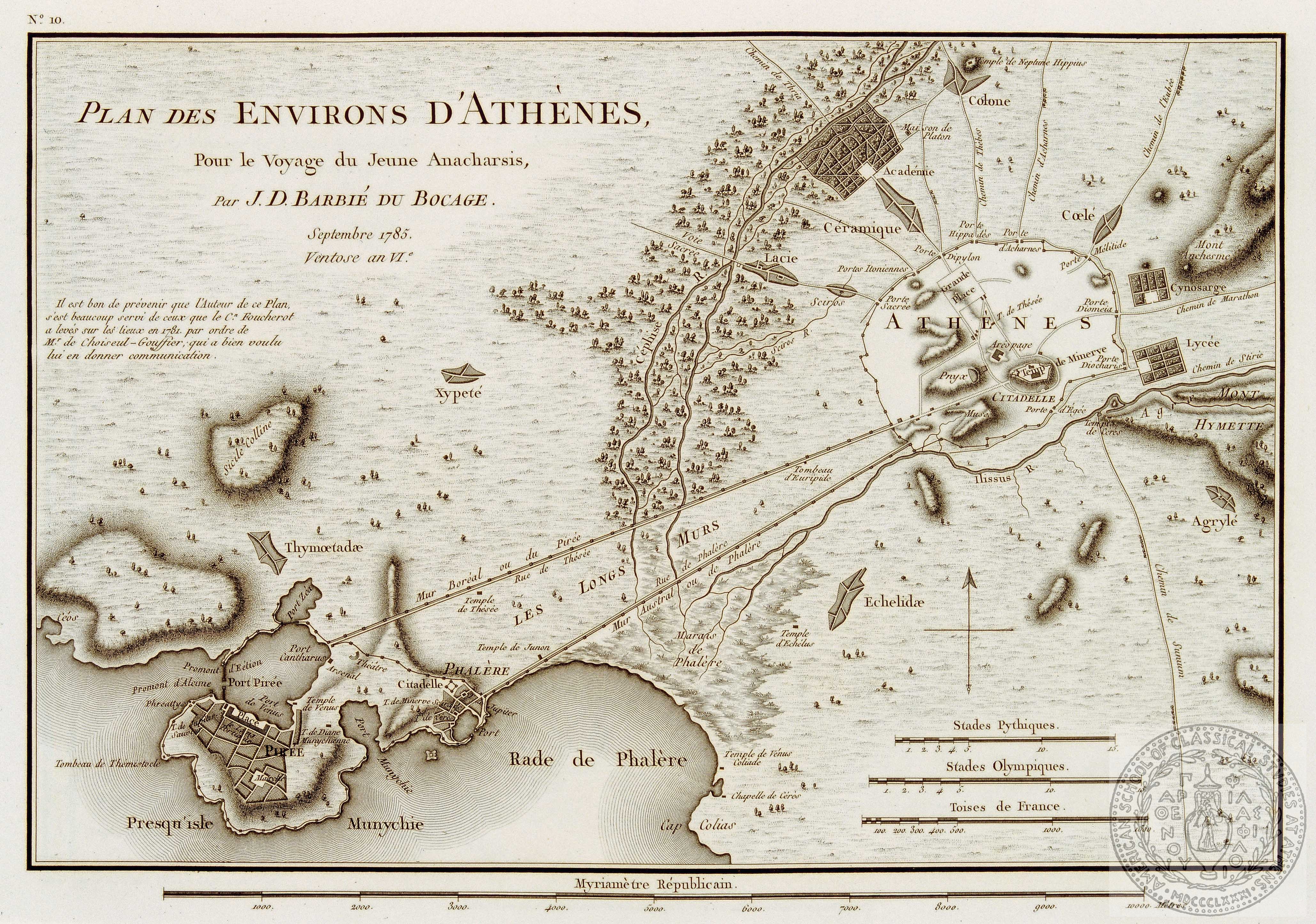
Plan des Environs d' Athenes, pour le Voyage du Jeune Anacharsis…
This plan was prepared for Didot's edition of Barthelemy's "Voyage du Jeune Anacharsis", Paris, 1799. It forms plate 10 in the edition in which it was published.It is based on measurements by Foucherot, carried out at the orders of Choiseul-Gouffier.
sheet 3 (36) at leaf 6
[1798-99]
Barbie du Bocage
J.
[Didot?]
Paris
Publisher
1 map on 1 sheet
22 x 32.5 cms.
Europe-Greece-Athens
ASCSA-G
2771

PH 40
In Scrapbook
Plan d' Athenes pour le Voayge du Jeune Anacharsis..
This plan, probably constructed by Barbie du Bocage, was prepared for Didot's edition of Barthelemy's Voyage du Jeune Anacharsis, Paris, 1797. It froms plate 10 in the edition in which it was published. According to a note in Gennadius's hand, it comes fr
sheet 4 (37) at leaf 6
[1797-98?]
Tardieu
P.
[Didot]
Paris
Publisher
1 map on 1 sheet1
21.8 x 32.5 cms.
Europe-Greece-Athens
ASCSA-G
2772
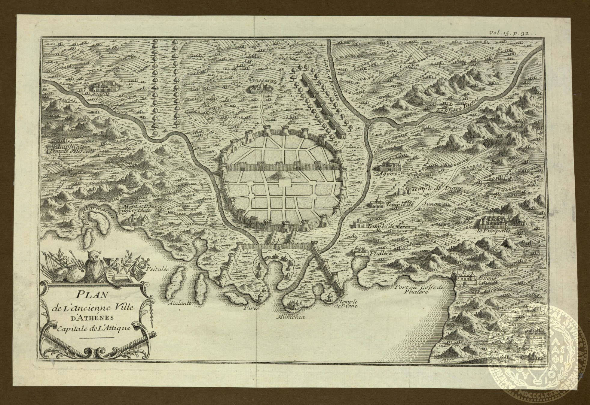
PH 40
In Scrapbook
Plan de l' ancienne Ville d' Athenes Capitale de l"Attique
There is a page reference in the margin: Vol. 15, p.32.
leaf 6v
[17--?]
1 map on 1 sheet
18.7 x 29 cms.
Europe-Greece-Athens
ASCSA-G
2773

PH 29.v.3
In Scrapbook
Voyage d' Enee. Tire de Virgile
loose leaf 2
1705
Fer
Nicolas
N. de Fer
Paris
Printer
1 map on 1 sheet
24.3 x 33.2 cms.
Europe-Mediterranean Sea
ASCSA-G
2625
PH 29.v.3
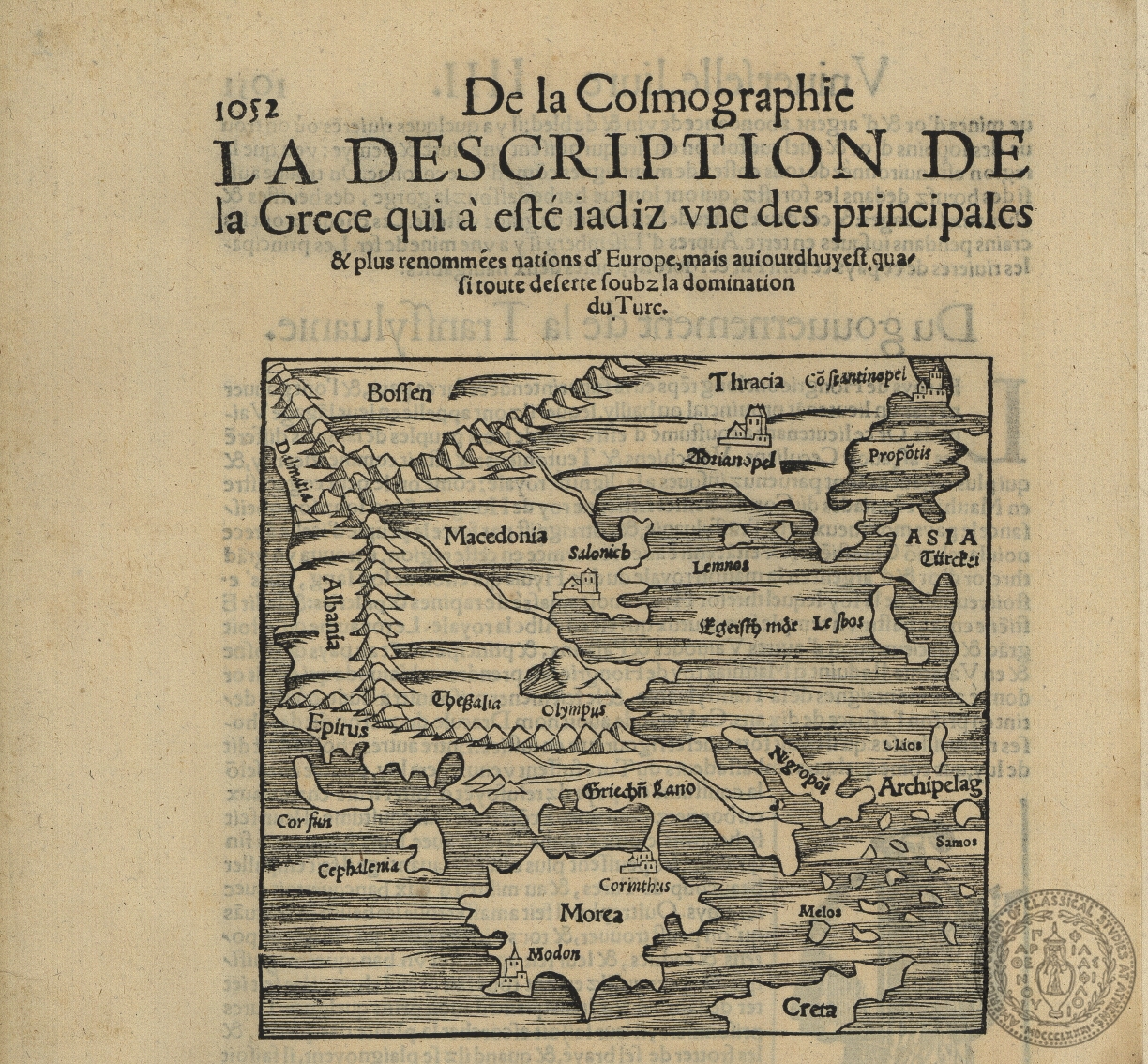
In Scrapbook
[Greece]
text caption: La Description de la Grece… running headline: De la cosmographie Universelle, livre III
no.1
[16--?]
1 map
12.5 x 13.3
Greece Aegean Islands (Greece and Turkey) Thrace, eastern (Turkey)
ASCSA-G
2626
PH 29.v.3
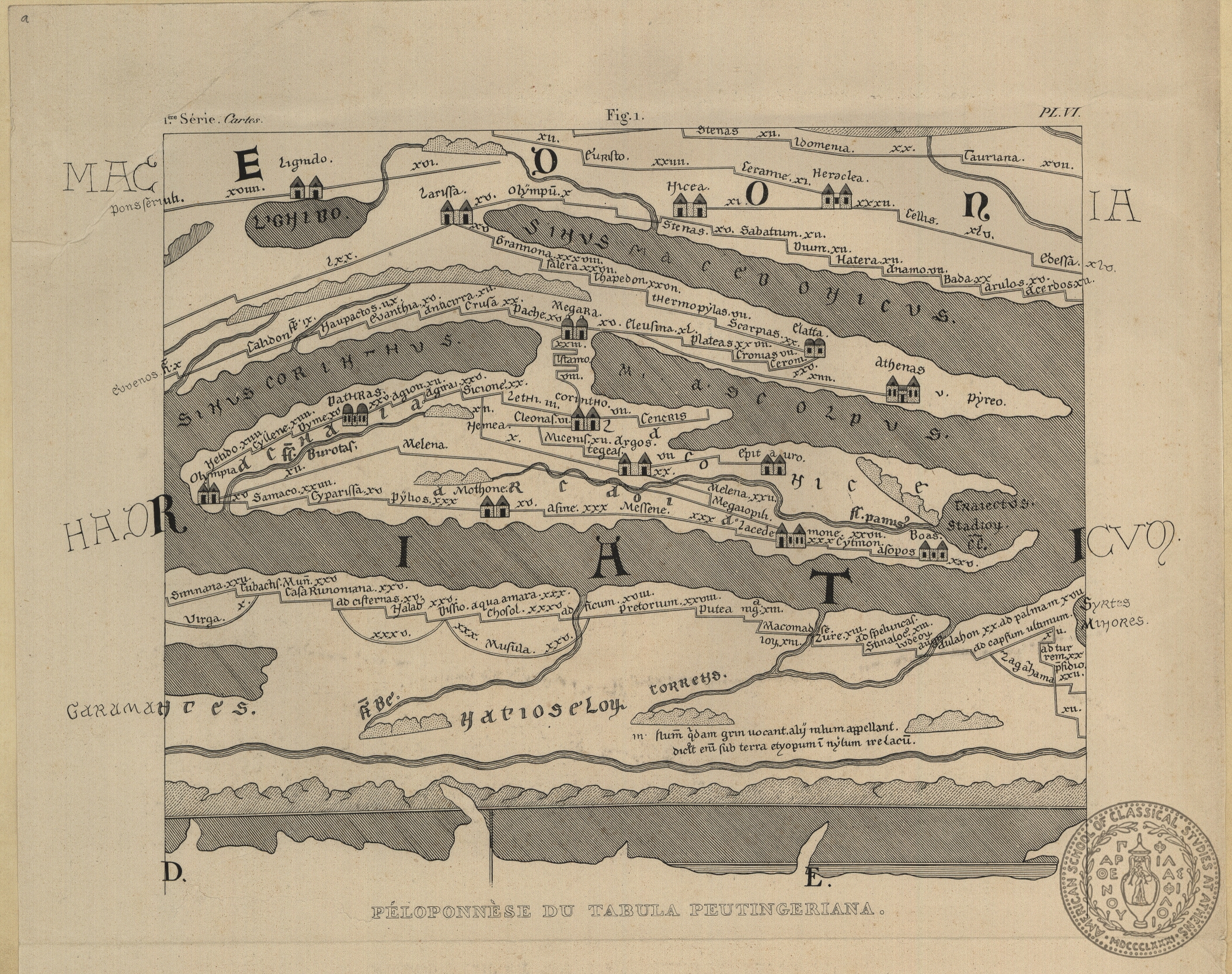
In Scrapbook
Peloponnese du Tabula Peutingeriana
probably from the Expedition scientifique de la Moree, 1832-36, edited and published under the supervision of Jean Baptiste Bory de St. Vincent.
no. 2.1
[ca.1830]
1 map on 1 sheet
22.5 x 27.2
Europe - Greece - Peloponnesus
ASCSA-G
2627
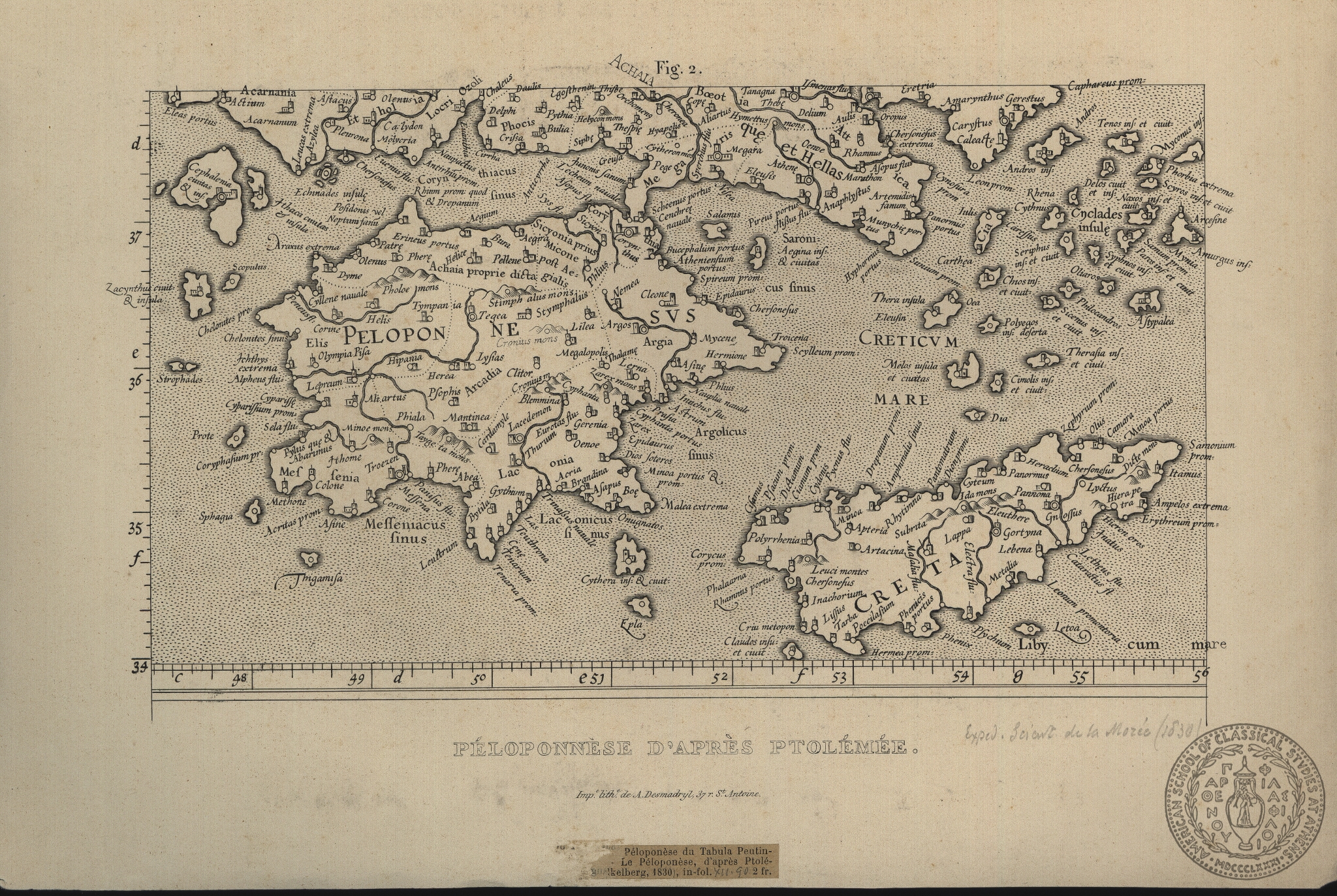
PH 29.v.3
In Scrapbook
Peloponnese d'apres Ptolemee
probably from the Expedition scientifique de la Moree, Paris, 1830
no. 2.2
[ca.1830]
Desmadryl
A.
[Paris]
1 map on 1 sheep
16 x 27.7 cms
Europe - Greece - Peloponnesus
ASCSA-G
2628

PH 29.v.3
In Scrapbook
Nona Evrope Tabula
ninth map of Europe (Balkans) from Ptolemy's Geographia. Contemporary colour
no. 3
1513
Ptolemaeus
Claudius
Schott, Johannes
Strasbourg
Printer
1 mapon 1 sheet
39 x 52.5 cms.
Balkan Peninsula Europe - Greece, northern Greece - Ionian Islands - Corfu Greece - Aegean Islands - Lemnos
ASCSA-G
2629

PH 29.v.3
In Scrapbook
Tabula Moderna Bossine. Servie. Gretiae et Scalvonie
The modern map of Greece and the Balkans from the 1513 edition of Ptolemy's Geography published at Strasbourg by Johannes Schott, with cartographic work by Martin Waldseemueller
no. 4
1513
Ptolemaeus
Claudius
Schott, Johannes
Strasbourg
1 map on 1 sheet
40.5 x 54.5 cms.
Europe - Balkan Peninsula Europe- Greece Europe- Greece- Aegean islands (Greece and Turkey) Asia - Turkey Coast (Asia Minor)
ASCSA-G
2630
PH 29.v.3
In Scrapbook
Europa recens delcripta a Guilielmo Blaeuw
Scale bar: 5 cms = 30 lieues de 25 à degré. This map is numbered '37'.
loose leaf.1 (f)
1833
Thierry
1map on 1 sheet
52 x 61
Europe - Greece - Aegean
ASCSA-G
2631

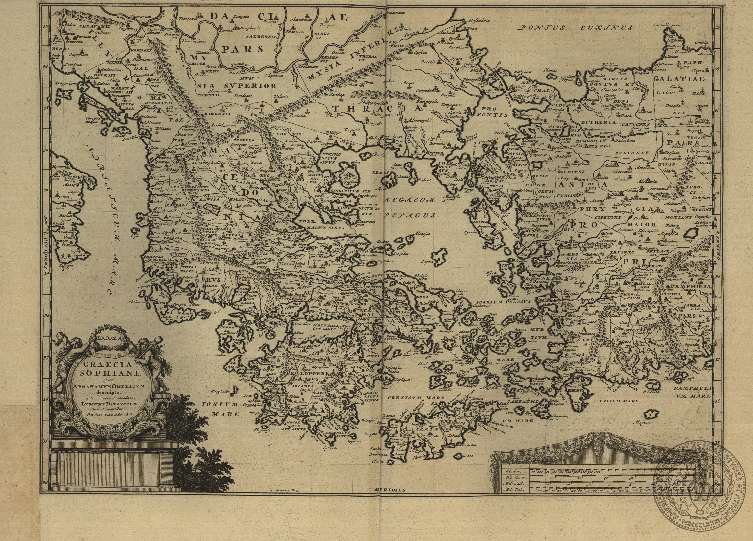
PH 29.v.3
In Scrapbook
[Ellas] Graecia Sophiani
Sophianos's map of Greece was published by a number of publishers. According to the statement on the map face 'Ex conatibus Geographicis Abrahami Ortelii Antverpiensis, this is the version which was published by Jodocus Hondius in his edition of Mercator'
no. 5
1636
Ortelius
Abraham
Hondius, Jodocus
Amsterdam
Publisher
1 map on 1 sheet
49.5 x 36.3 cms.
Europe - Greece Europe - Greece - Aegean Europe - Balkans
ASCSA-G
2632
PH 29.v.3
In Scrapbook
[Ellas] Graecia Sophiani
Van der Aa's version of Sophianos's map of Greece, based on the cartographic image published by Abraham Ortelius. Copies of the map published by Sophianos himself are extremely rare.
no. 6
[ca.1714]
Ortelius
Abraham
Engraver
Pieter vander AA
Leiden
Publisher
1 map on 1 sheet
34.5 x 47.7 cms.
Europe - Greece Europe- Balkan Peninsula Europe - Greece - Aegean islands
ASCSA-G
2633
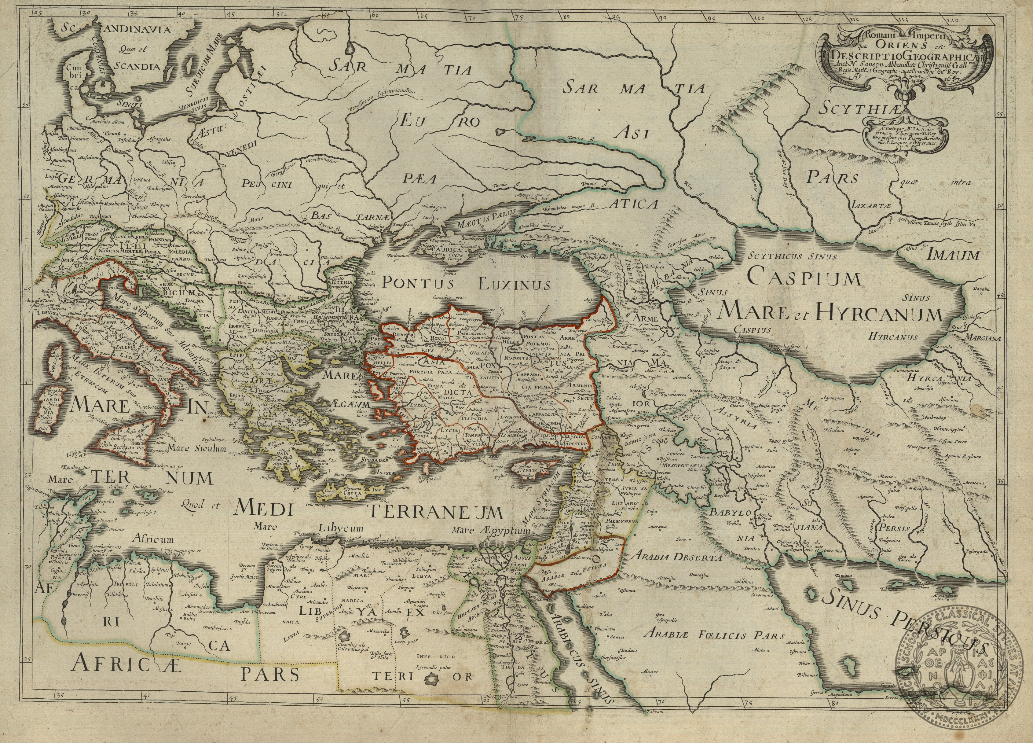
PH 29.v.3
In Scrapbook
Romani Imperii qua Oriens est Descriptio Geographicarum
Map shows the extent of the Roman Empire
no. 7
1637
Sanson
Nicolas
Mariette, Pierre
Paris
Publisher
1 map on 1 sheet
39.3 x 55.5 cms.
Europe - Germany, Italy, Greece, Dalmatia Asia - Turkey, Armenia, Arabia, Sarmatia, Scythia Africa - North Africa
ASCSA-G
2634
PH 29.v.3
In Scrapbook
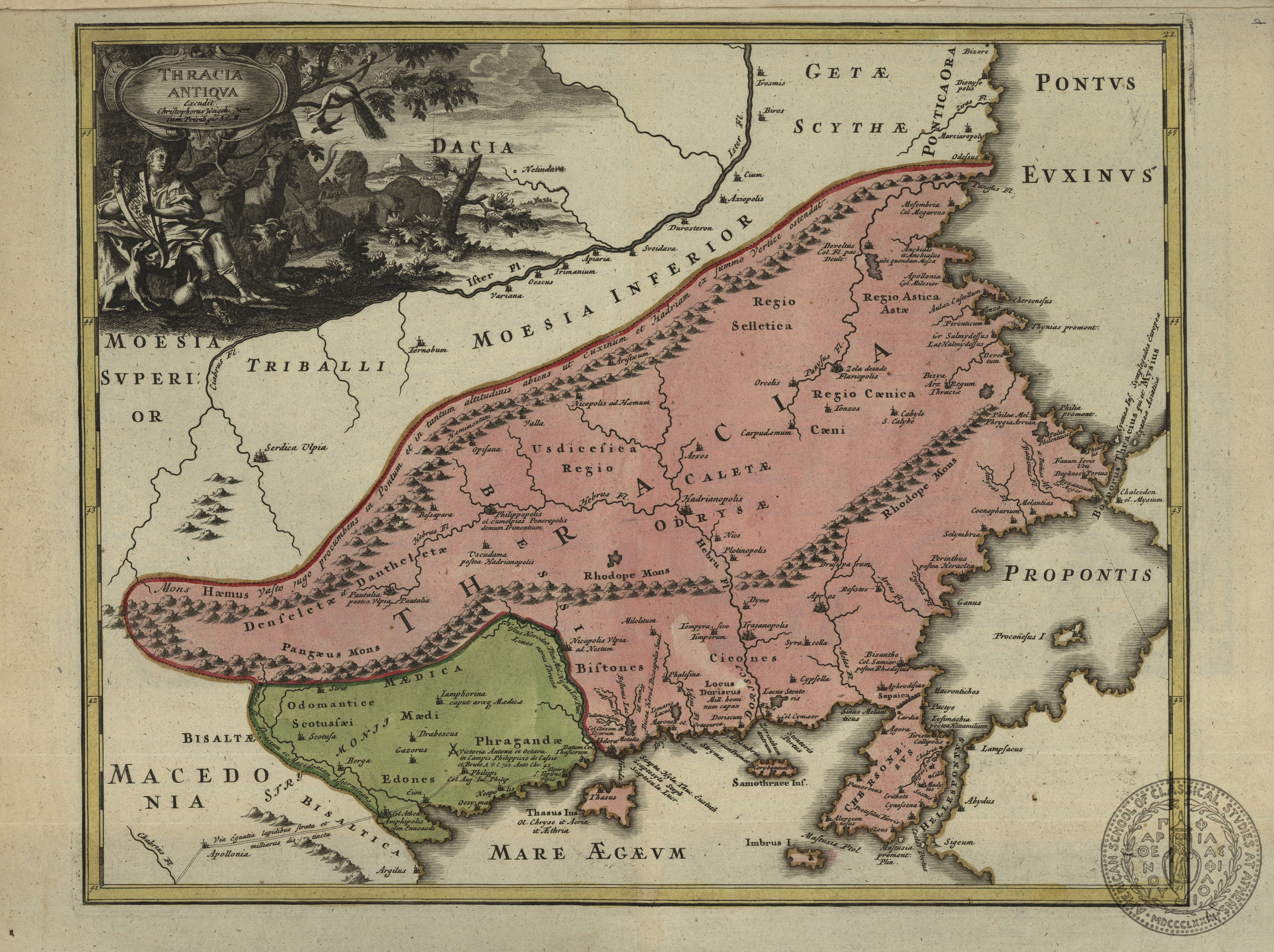
Thracia Antiqua
no.12
[17--]
Weigel
Christopher
Nuremberg
1 map on 1 sheet
31 x 38.5 cms.
Europe- Greece- Thrace Europe- Balkans Europe-Turkey-Dardanelles Europe-Greece-Northern Aegean
ASCSA-G
2635

PH 29.v.3
In Scrapbook
Graeciae Septentionalis Pars
This map does not have a cartouche; the title is taken from the caption. The dimensions of the map include the caption.
no. 13
[17--]
Weigel
Christopher
Weigel, Christopher
Nuremberg
Printer
1 map on 1 sheet
30 x 41 cms.
Europe - Greece- Central Europe - Greece - Northern Aegean Europe - Balkans Europe - Greece - Ionian islands - Corfu
ASCSA-G
2636

PH 29.v.3
In Scrapbook
Graeciae Pars Meridionalis: Graeciae Antiquae Tabula Nova
This map has a cartouche and a caption. The cartouche title is given first.
no. 14
[17--]
Weigel
Christopher
Weigel, Christopher
[Nuremberg]
Publisher
1 map on 1 sheet
30.5 x 41 cms.
Europe-Greece-Peloponnesus Europe-Greece-Southern Aegean Asia-Turkey-western coast of Asia Minor
ASCSA-G
2637

PH 29.v.3
In Scrapbook
Graecia Vetus
With an inset entitled 'Supplementum' with depictions of Attica, Boeotia, the isthmus of Corinth and part of the Peloponnese
no.15
[18--]
Bonne
Roberto
artist
1 map on 1 sheet
23.2 x 34.5 cms.
Europe- Balkans-Albania, Macedonia, Thrace Europe-Greece Europe-Greece-Aegean Asia-Turkey-western coast of Asia Minor
ASCSA-G
2638

PH 29.v.3
In Scrapbook
Graecia Antiqua
no. 16
[18--]
Philippe
Engraver of toponyms
[Paris]
1 map on 1 sheet
265 x 37 cms.
Europe-Balkans-Black Sea Europe-Greece Europe-Greece-Aegean Sea
ASCSA-G
2639
PH 29.v.3
In Scrapbook
Graecia Antiqua
With an inset entitled 'Graecia Partes Boreales'
no. 17
1785
Zatta
Antonio
Zatta, Antonio
Venice
Publisher
1 map on 1 sheet
40.5 x 31 cms.
Europe-Greece Europe-Greece-western Aegean
ASCSA-G
2640
PH 29.v.3
In Scrapbook
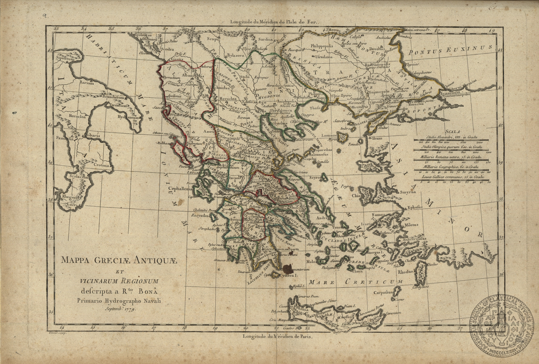
Mappa Greciae Antiquae et vicinarum regionum
Bona may be a variant spelling of Bonne, see PH 29.v.3, no. 16
no. 18
1779
Bona [Bonne]
Roberto
Engraver
1 map on 1 sheet
Europe-Turkey-Eastern Thrace Europe-Greece Europe-Greece-Aegean Europe-Southern Italy
ASCSA-G
2641

PH 29.v.3
In Scrapbook
La Grece tiree des Memoires de Monsieur l' Abbe Baudrand
With a dedicatory cartouche to Louis Boucherat, Chancellor of France
no. 19
[17--]
Baudrand
Besson, Jean
Paris
Publisher
1 map on 1 sheet
44 x 55 cms.
Europe-Greece Asia-Turkey-coast of Asia Minor
ASCSA-G
2642

PH 29.v.3
In Scrapbook
Nova Totius Graeciae Descriptio
This map has been attributed by Zacharakis (Catalogue of Printed Maps of Greece, Athens, 1992) to the publisher Jan Janssonius, for his Atlas Novus, which appeared in many editions from 1638 to 1661
no. 22
[1638]
Mercator
Gerard
[Jan Janssonius]
[Amsterdam]
Publisher
1 map on 1 sheet
35.8 x 46 cms.
Europe-Greece Europe-Greece-northern and central Aegean Asia-Turkey-coast of Asia Minor
ASCSA-G
2643

PH 29.v.3
In Scrapbook
Thessaliae acccurata Descriptio
coloured in outline
no. 23
[17--]
Laurenberg
I.
1 map on 1 sheet
38.8 x 50.3 cms.
Europe-Greece-Central Greece
ASCSA-G
2644

PH 29.v.3
In Scrapbook
Macedonia Epirus et Achaia
Published in Blaeu's Atlas major sive Cosmographia Balviana, Amsterdam, 1662
no. 28
[1662]
Blaeu
Willem
Blaeu
[Amsterdam]
Publisher
1 map on 1 sheet
41 x 49.5 cms.
Europe-Balkans-Dalmatia Europe-Greece-central and northern
ASCSA-G
2645

PH 29.v.3
In Scrapbook
Macedonia Epirus et Achaia
attributed to the publisher Janssonius by Zacharakis (Catalogue of printed maps of Greece, Athens, 1992)
no.29
[1638]
Mercator
Gerard
[Jan Janssonius]
Amsterdam
Publisher
1 map in 1 sheet
35.8 x 42 cms.
Europe-Balkans Europe-Greece-central and northern
ASCSA-G
2646
PH 29.v.3
In Scrapbook
Macedonia Epirus et Achaia
this is a duplicate of map 28 in the same volume
no. 30
[1662]
Blaeu
G.
Blaeu
[Amsterdam]
Publisher
1 map on 1 sheet
41 x 49.5 cms.
Europe-Balkans Europe-Greece, central and northern
ASCSA-G
2647

PH 29.v.3
In Scrapbook
Romaniae (quae olim Thracia dicta) vicinarumq[ue] Regionum, uti Bulgariae, Walachiae, Syrfiae [sic], etc. Descriptio
The name of the cartographer on this map is given as 'Iacobo Castaldo'. This name is also spelled Giacomo Castaldi, Giacomo Castaldo, Giacomo Gastaldi. This map was published by Ortelius in Amsterdam as part of the 'Theatrum Orbis Terrarum'.
leaf 32
[1584]
Castaldi
Giacomo
Ortelius
[Amsterdam]
Publisher
1 map on 1 sheet
36.5 x 50 cms.
Europe-Balkans-Bulgaria, Romania, part of Albania and Serbia, from Eastern Thace to the Bosphorus and the Dardanelles
ASCSA-G
2648

PH 29.v.3
In Scrapbook
Thraciae veteris Typus. Ex conatibus Geographicis Abrah. Ortelii
Ortelius is the original cartographer and this map was probably published by him in theTheatrum Orbis Terrarum. Contemporary colour. There are two cartouches with geographical information on Thrace and Byzantium. If this is an Ortelius map it can be seen
leaf 33
1585
Ortelius
Abraham
Ortelius?
[Antwerp]
Publisher
1 map on 1 sheet
35.3 x 47.5 cms.
Europe-Thrace (ancient)- Mt. Athos, Lemnos, Thasos, Imbros, Tenedos, Samothrace, Bosphorus, Dardanelles
ASCSA-G
2649

PH 29.v.3
In Scrapbook
Walachia Servia, Bulgaria, Romania.
This is from a German edition of Mercator's atlas. The cartouche contains a shield with a crescent. Contemporary colour.
leaf 35
[ca.1600]
Mercator
Gerard
Mercator
Publisher
1 map on 1sheet
34.5 x 46.7 cms.
Europe-Balkans-Bulgaria, Romania, eastern Thrace to the Bosphorus. The area north of Thessaloniki
ASCSA-G
2650

PH 29.v.3
In Scrapbook
Candia olim Creta.
Mariette published an edition of Sanson's maps in 1665 under the title 'Cartes generales toutes les parties du Monde'.
leaf 46
[1665]
Mariette
Pierre
Cartographer
Pierre Mariette
Paris
Publisher
1 map on 1 sheet
37.5 x 51 cms.
Europe-Greece-Crete
ASCSA-G
2659

PH 29.v.3
In Scrapbook
Insular. Aliquot Aegaei Mari antiqua Descrip.// Rhenia-Delus/ Euboea insula/ Samus/ Cia et Ceos/ Lesbos/ Lemnos/ Cyprus…/ Chios/ Rhodus/ Icaria.
This composite map has Cyprus as the main map, surrounded by insets of various Greek islands.It has been described in many catalogues and is depicted on line in Orteliusmaps.com.
leaf 48
1584
Ortelius
Abraham
Ortelius
[Antwerp]
Publisher
10 maps on 1 sheet
36.3 x 47 cms.
Asia-Cyprus Europe-Greece-Delos- Europe-Greece-Euboea Europe-Greece-Samos Europe-Greece-Zea Europe-Greece-Mitylene Europe-Greece-Lemnos Europe-Greece-Chios Europe-Greece-Rhodes Europe-Greece-Icaria
ASCSA-G
2660

PH 29.v.3
In Scrapbook
Cyprus Insula
This map contains two coats of arms on the map surface. It may be the map of Cyprus published by Blaeu in 1635, which also contained two coats of arms, one of which is that of the Ottoman empire. If so it has been described in several catalogues.
leaf 49
[1635?]
[Blaeu?]
Amsterdam?
Publisher
1 map on 1 sheet
38 x 50.5 cms.
Asia-Cyprus
ASCSA-G
2661

PH 29.v.3
In Scrapbook
La Grecia divisa nelle sue Provincie di nuova projezione…
contains two scales, one of which is of Turkish miles.
leaf 50
1781
Zatta
Antonio
engraver of the lettering
Antonio Zatta
Venice
Printer-publisher
1 map on 1 sheet
40.5 x 31 cms.
Europe-Greece Europe-Albania
ASCSA-G
2662

PH 29.v.3
In Scrapbook
Grece moderne ou partie meridionale de la Turquie en Europe divisee en Beglerbegliks, ou Grands Gouvernements.
Accompanied by an engraved leaf: Description de la Grece moderne, par N. de Fer.
leaf 50b
1705
Fer
Nicolas de
N. de Fer
Paris
Publisher
1 map on 1 sheet
22.2 x 33.3 cms.
Europe-Greece Europe-Albania Europe-Turkey
ASCSA-G
2663