

GT 225.3q
In Book
Imperium Romanum
with 1 inset: Italy -- Lazio
285v-286r
[ca. 1650]
Briet
Phil.
Joannes Janssonius]
Amsterdam]
Publisher
1 map
38 x 52,5
Europe, Turkey, Middle East, North. Africa
ASCSA-G
633

GT 225.3q
In Book
Lumen historiarum per occidentem
293v-294r
[ca. 1650]
Haraei
Fran.
Joannes Janssonius]
Amsterdam]
Publisher
1 map
38 x 47,5
Europe, north Africa
ASCSA-G
635

GT 225.3q
In Book
Segmentum VI a Sarmatis Roxulanis usque ad Parnacos
311v-312r
[ca. 1650]
Velseri
Marci
Joannes Janssonius]
Amsterdam]
Publisher
1 map
18,5 x 51,5
Asia -- Turkey, north Africa Europe -- Crete
ASCSA-G
642

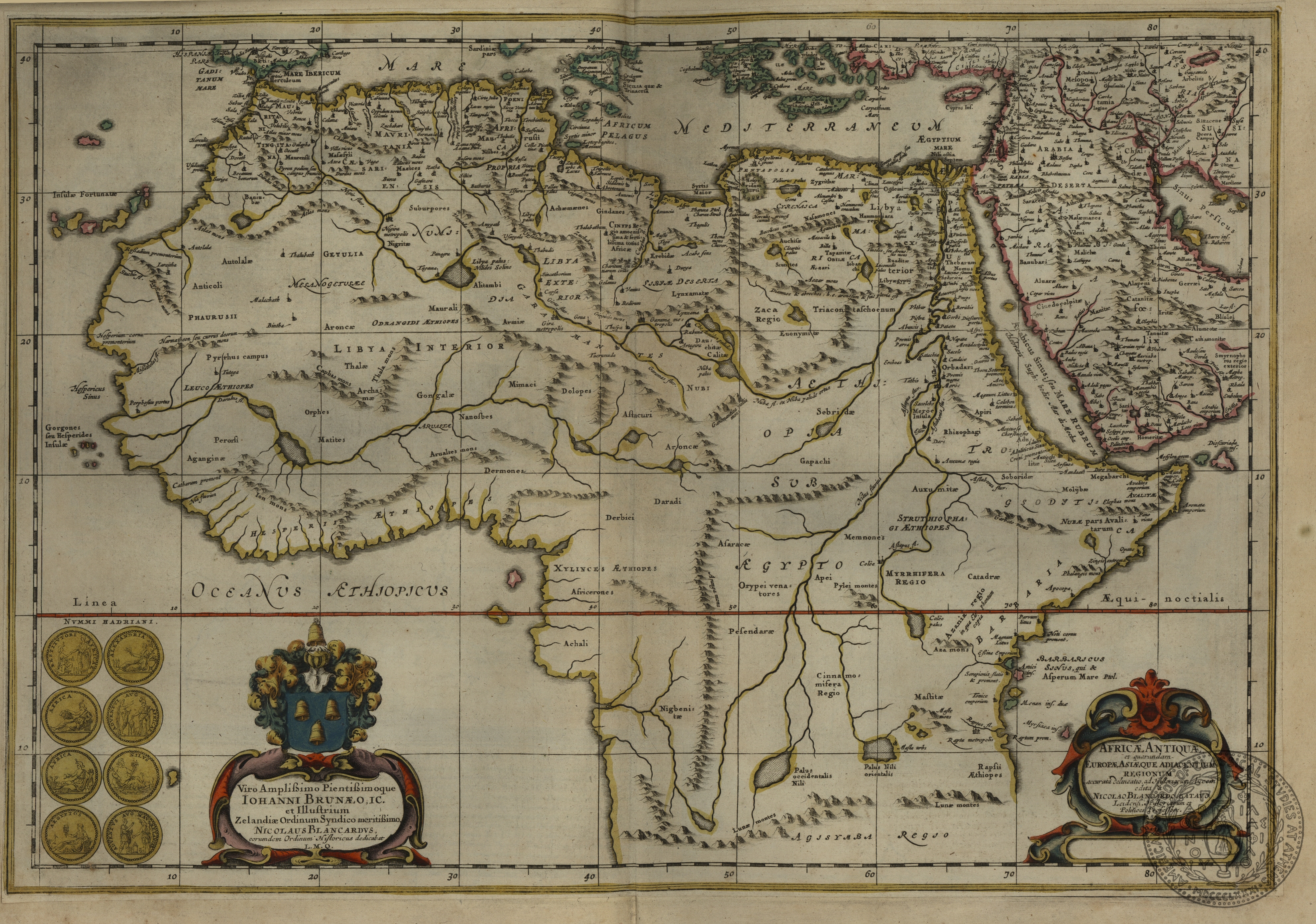
GT 225.3q
In Book
Africae antiquae et quarundam Europae Asiaeque adiacentium regionum
between p.8-9
[ca. 1650]
Blancardus
Nicolaus
Joannes Janssonius]
Amsterdam]
Publisher
1 map on 2 sheets
37 x 53
Africa
ASCSA-G
648

GT 225.3q
In Book
Geographia sacra
9v-10r
[ca. 1650]
Ortelius
Abraham
Joannes Janssonius]
Amsterdam]
Publisher
1 map on 2 sheets
36 x 48, 5
Europe, Asia, Africa
ASCSA-G
649
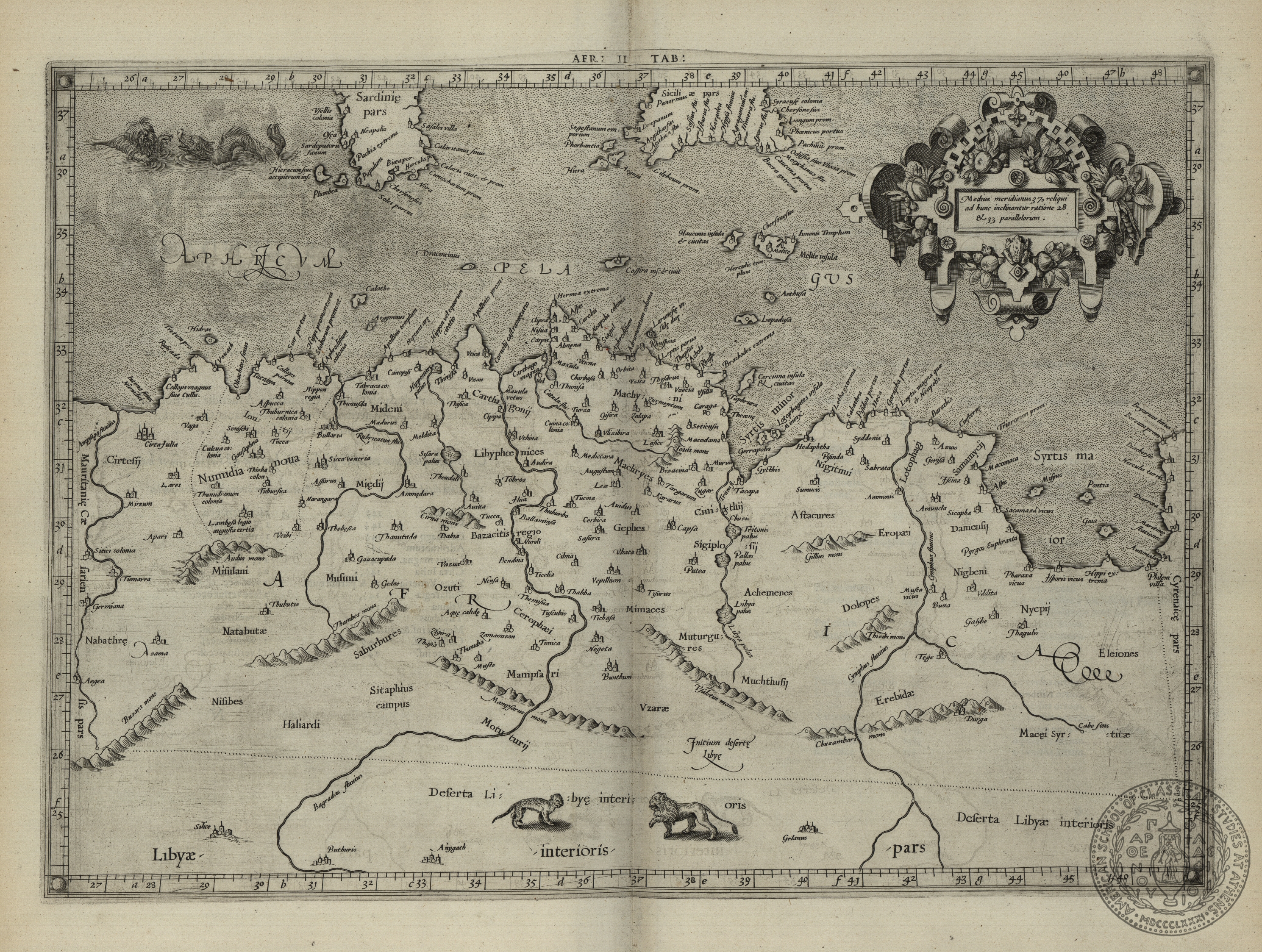
GT 225.3q
In Book
Africae antiquae et quarundam Europae , Asiaeue adiacentium regionum
With riproduction of 4 ancient coins
63v-64r
[ca. 1650]
Blancardo
Nicolao
Joannes Janssonius]
Amsterdam]
Publisher
1 map
37,5 x 55
Africa
ASCSA-G
660

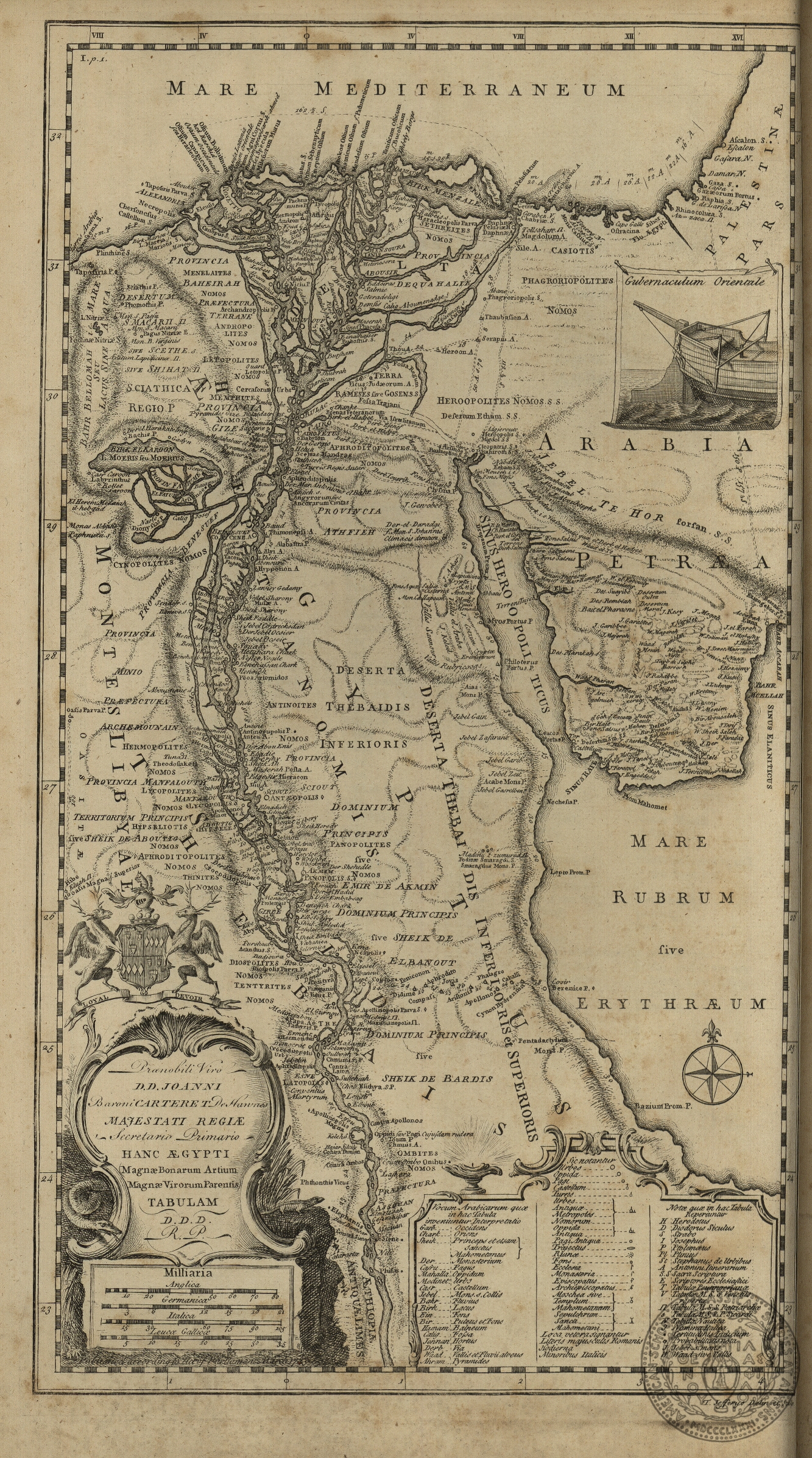
GT 225.3q
In Book
Aegyptus antiqua divisa in nomos
67v-68r
[ca. 1650]
Duval
P.
Joannes Janssonius]
Amsterdam]
Publisher
1 map
38 x 52,5
Africa -- Egypt
ASCSA-G
661

GT 225.3q
In Book
Africae propriae tabula: in qua Punica regna vides, Tyrios et Agenoris urbem
77v-78r
[ca. 1650]
Joannes Janssonius]
Amsterdam]
Publisher
1 map
37,5 x 52,5
Africa -- northern Africa
ASCSA-G
663

GT 225.3q
In Book
Argonautica
with 3 insets: Europe Greece -- Magnesia Asia -- Turkey, Propontis
189v-190r
[ca. 1650]
Kaerius
Petrus
Joannes Janssonius]
Amsterdam]
Publisher
1 map
37,5 x 51
Europe Asia -- Turkey, Black Sea North Africa
ASCSA-G
664

GC 2853.53Bq
In Book
Universalis tabula iuxta Ptolemaeum
augmented and corrected by Petrus Bertius
plate A
1618
Mercator
G.
Iudocus Hondius
Amsterdam
Publisher
1 map
35 x 48,5
Europe, Asia, Africa
ASCSA-G
888

GC 2853.53Bq
In Book
Africae tabula prima continens ambas Mauritanias, Tingitanam, et Caesariensem
augmented and corrected by Petrus Bertius
plate M
1618
Mercator
G.
Iodocus Hondius
Amsterdam
Publisher
1 map
32,5 x 48
Africa -- northwestern Africa
ASCSA-G
899
GC 2853.53Bq
In Book
Africae tabula secunda continens Africam minorem, cum insulis ipsi adsitis
augmented and corrected by Petrus Bertius
plate N
1618
Mercator
G.
Iodocus Hondius
Amsterdam
Publisher
1 map
34 x 48
Africa -- centralnorthern Africa
ASCSA-G
900

GC 2853.53Bq
In Book
Africae tabula tertia continens Cyrenaicam et Aegyptum, cum adiacentibus insulis
augmented and corrected by Petrus Bertius
plate O
1618
Mercator
G.
Iodocus Hondius
Amsterdam
Publisher
1 map
34,5 x 49
Africa -- Egypt
ASCSA-G
901

GC 2853.53Bq
In Book
Africae tabula quarta continens Libyam interiorem, Aethiopiam quae sub Aegypto est et Aethiopiam interiorem
augmented and corrected by Petrus Bertius
palte P
1618
Mercator
G.
Iodocus Hondius
Amsterdam
1 map
31,5 x 48,5
Africa -- Egypt, Ethyopia
ASCSA-G
902

GT 230q
In Book
Imperium turcicum: in Europa, Asia et Africa regiones proprias tributarias clientelares exhibens
9
[17--]
Hasio
M.
J. Homann
Nuremberg
Publisher
1 map
48,5 x 57
Europe -- Italy, Greece Asia -- Turkey, Middle East, Arabia Africa -- Egypt, northern Africa
ASCSA-G
673
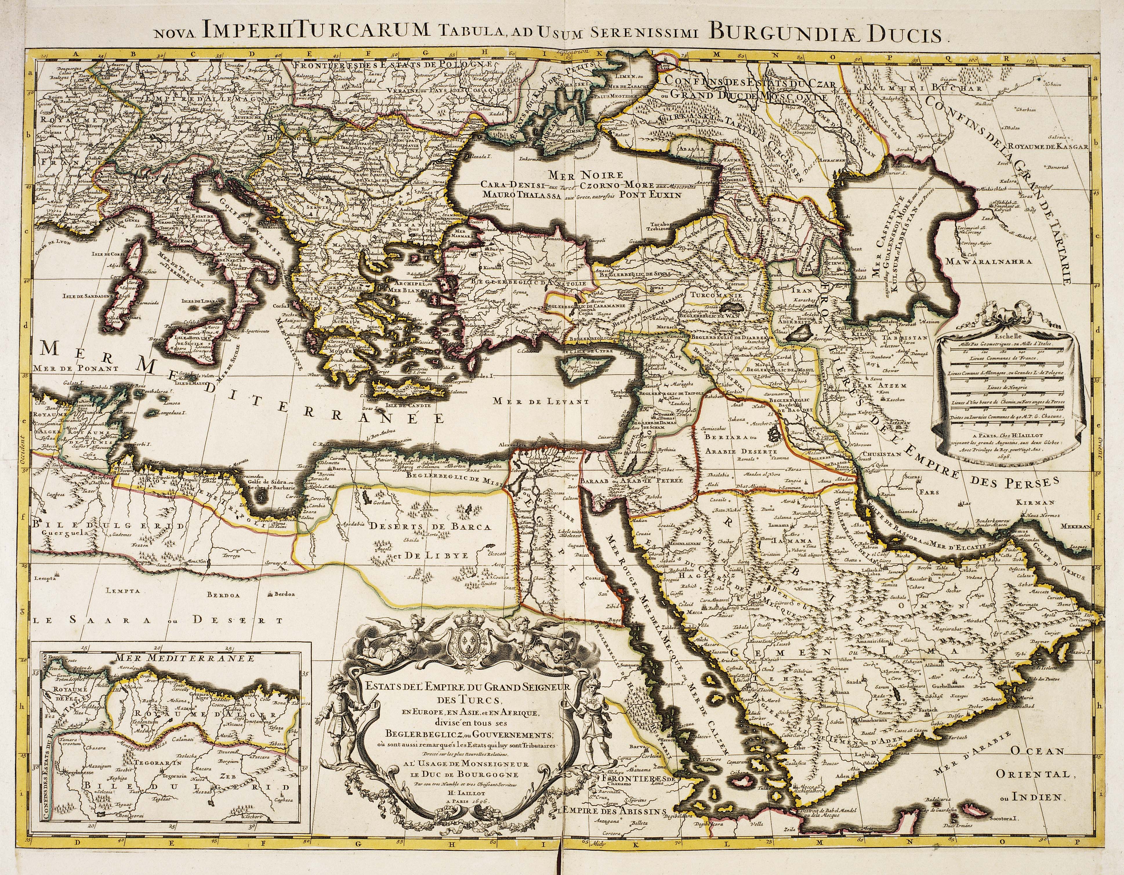
GT 230q
In Book
Estats de l' Empire du Grand Seigneur des Turcs: en Europe, en Asie et en Afrique, divise en tous ses beglerbeglicz ou gouvernements, ou sont aussi remarques les Estats qui luy sont tributaires. Dresse sur les plus nouvelles relations, al' usage de Monsei
with 1 inset: Africa -- Algeria
10
[1696
Jaillot
H.
H. Jaillot
Paris
Publisher
1 map
44,5 x 61,5
Europe -- Italy, Greece Asia -- Turkey, Middle East, Arabia Africa -- Egypt
ASCSA-G
674

GT 230q
In Book
Mer mediterranee
38a
[1700?]
Roux
Joseph
Joseph Roux
Marseille
Publisher
1 map
80 x 56
Europe -- Greece -- Pelponnese Africa -- northern Africa
ASCSA-G
701

GC 2853.53Bq
In Book
Africae propriae tabula in qua Punica regna vides Tyrios et Agenoris urbem
with 1 inset: Carthagine
plate III
1619
Ortelius
A.
Iudocus Hondius
Amsterdam
Publisher
1 map
34,5 x 48,5
Africa -- northern Africa
ASCSA-G
937

GC 2853.53Bq
In Book
Palaestinae, sive totius terrae promissionis nova descriptio auctore Tilemanno Stella sigenensi
augmented and corrected by Petrus Bertius
plate KKK
1619
Stella
Tilemann
Iudocus Hondius
Amsterdam
Publisher
1 map
34 x 46
Africa, Asia -- Egypt, Middle East
ASCSA-G
938
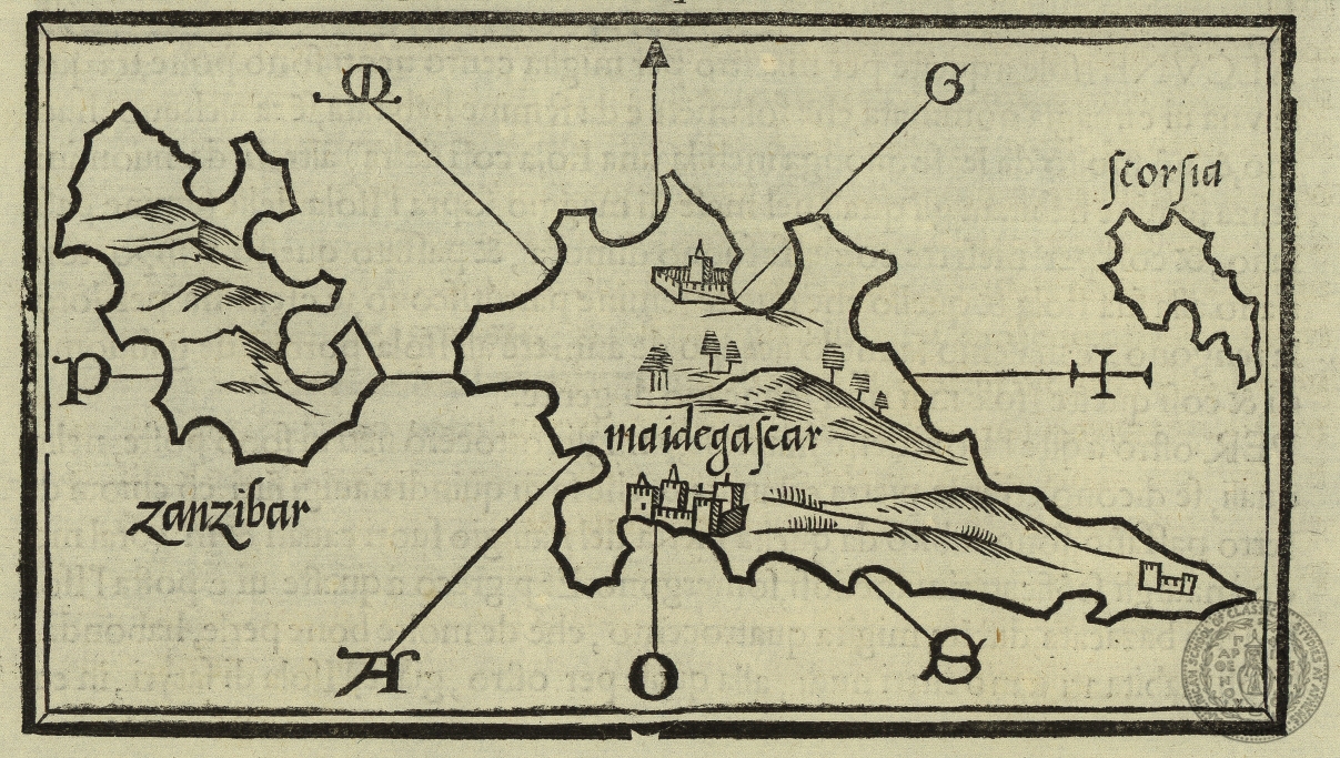
GT 2582B
In Book
Madagascar
LXXv
1534
Bordone
Benedetto
Nicolo d' Aristotile detto Zoppino
Venice
Publisher
1 map
8,5 x 14,5
Africa -- Madagascar
ASCSA-G
1313

GT 637q
In Book
A map of the western province of the kingdom of Algiers
pl.1
1738
Shaw
Thomas
Theatre - Oxford
Oxford
Publisher
1 map
30 x 44
Africa -- western Algeria
ASCSA-G
1736
GT 637q
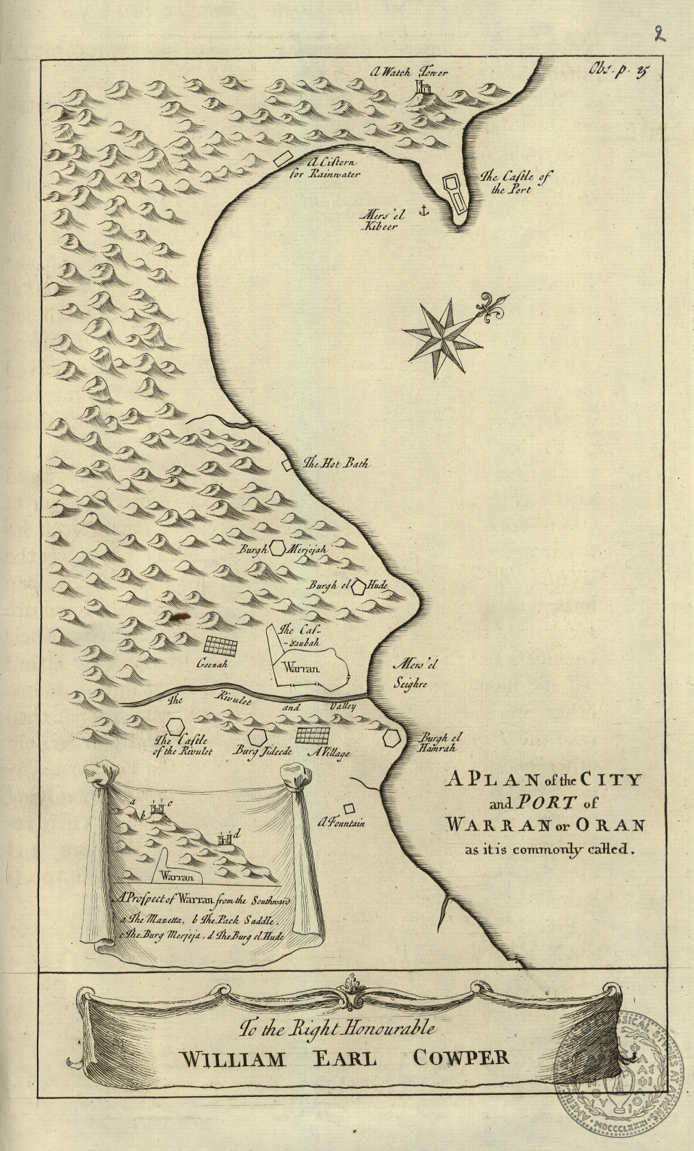
In Book
A plan of the city and port of Warran or Oran as it is commonly called
pl. 2
1738
Shaw
Thomas
Theatre - Oxford
Oxford
Publisher
1 map
26 x 15,5
Africa -- Algeria
ASCSA-G
1737
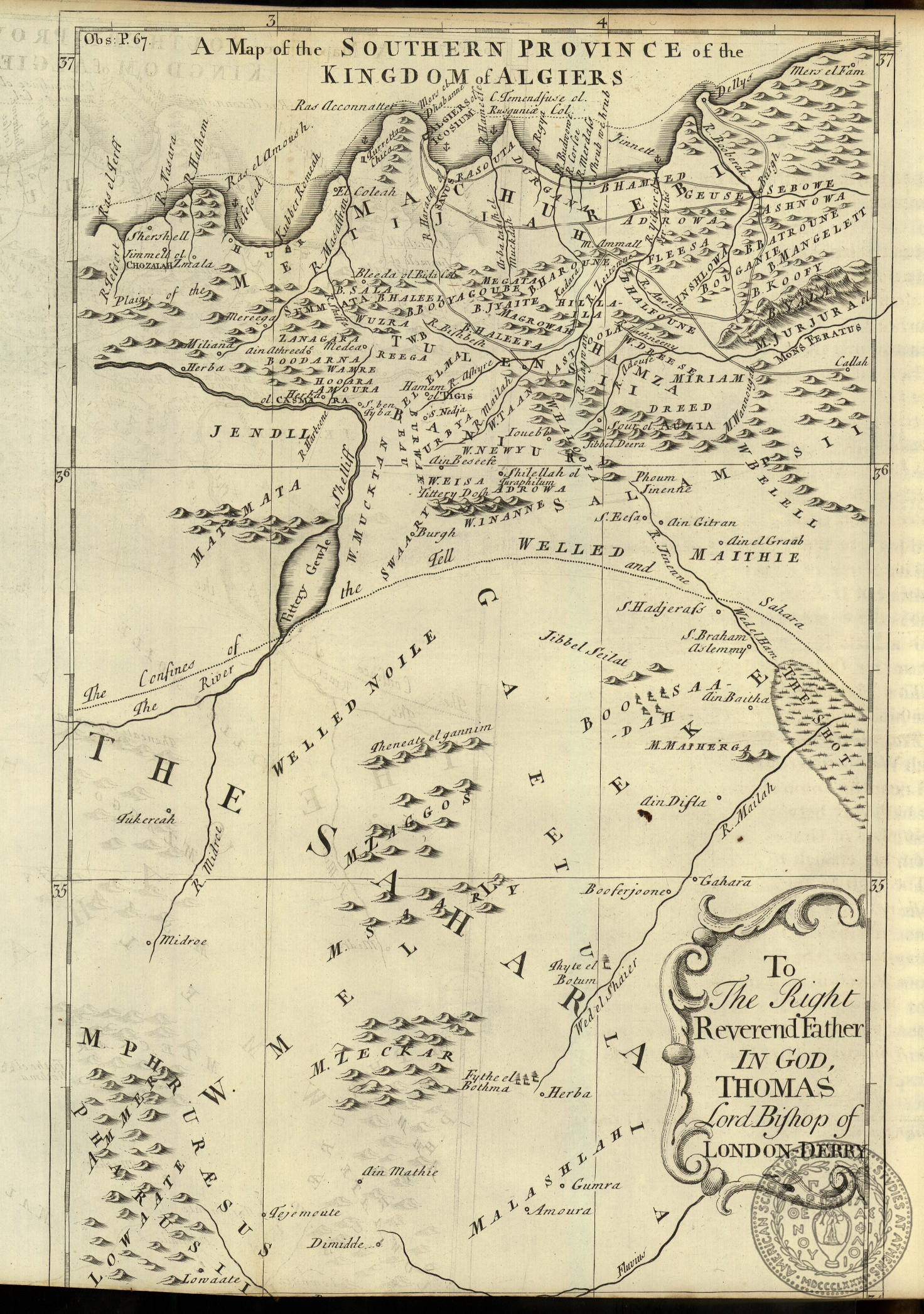
GT 637q
In Book
A map of the southern province of the kingdom of Algiers
pl.3
1738
Shaw
Thomas
Theatre - Oxford
Oxford
Publisher
1 map
35 x 22
Africa -- southern Algeria
ASCSA-G
1738
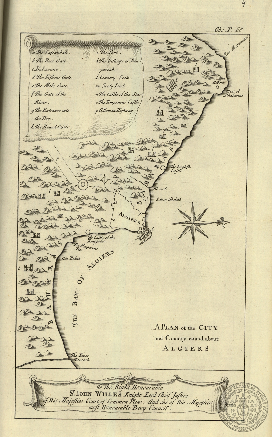
GT 637q
In Book
A plan of the city and country round about Algiers
pl.4
1738
Shaw
Thomas
Theatre - Oxford
Oxford
Publisher
1 map
26,5 x 15,5
Africa -- Algeria -- city of Algeri
ASCSA-G
1739

GT 637q
In Book
A map of the eastern province of the kingdom of Algiers
pl.5
1738
Shaw
Thomas
Theatre - Oxford
Oxford
Publisher
1 map
36,5 x 45,5
Africa -- eastern Algeria
ASCSA-G
1740

GT 637q
In Book
A map of the kingdom of Tunis
pl.6
1738
Shaw
Thomas
Theatre - Oxford
Oxford
Printer
1 map
45 x 33,5
Africa -- Tunisia
ASCSA-G
1741
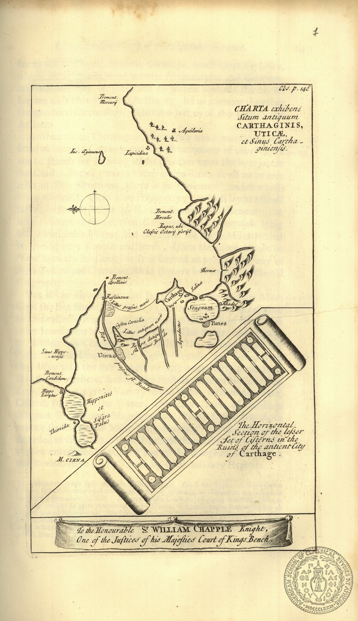
GT 637q
In Book
Charta exhibens situm antiquum Carthaginis, Uticae et sinus Carthaginensis
pl.7
1738
Shaw
Thomas
Theatre - Oxford
Oxford
Publisher
1 map
25,5 x 15,5
Africa -- Tunisia -- ancient Carthagena
ASCSA-G
1742

GT 1699.5q
In Book
Carte d' Ethiopie et de l' Empire des Abyssins….
pl.I
1673
d' Almeida
Manoel
Cartographer
Andre Cramoisy
Paris
Publisher
1 map
29 x 37
Africa -- Ethiopia
ASCSA-G
1835

GT 303
Loose
Carte de l' Empire du Maroc
1848
Depot General de la Guerre
Paris
Publisher
1 map
81 x 102
Africa -- Morocco
ASCSA-G
1994
GT 304
Loose
Carte de la Regence de Tunis
1857
Blondel
Depot General de la Guerre
Paris
Publisher
1 map
125,5 x 93,5
Africa -- Tunisia
ASCSA-G
1995

GT 307
Loose
Russisch-Turkisch-Persisch-Englische Grenzlaender von Bosnien bis Kaschgar und Indien
with 2 insets: island of Crete, the Delta of the river Nilus (Egypt)
1877
Petermann
A.
Justus Perthes
Gotha
Publisher
1 map
37 x 66
Europe -- The Balkans, Greece, Cyprus, Russia Asia -- Turkey, Middle East, Irak, Iran, India Africa -- northern Egypt
ASCSA-G
1997

GT 305.1
Loose
Carte physique et politique de la Syrie pour servir a l' histoire des conquetes du General Bonaparte en Orient
1803 ?
Charles
Paultre
Lapie -- Picquet
Paris
Publisher
1 map
50 x 73,5
Asia -- Middle East, Syria, Israel Africa -- northern Egypt
ASCSA-G
1999

GT 637.1q
In Book
[4 maps]
pl.1
1746
Shaw
Thomas
Theatre -- Oxford
Oxford
Publisher
4 maps
32,5 x 28,5
Asia -- Middel East -- Syria Africa -- Egypt, Red Sea
ASCSA-G
1759
GT 646q
In Book
[Egypt]
pl.1
1743
Pococke
Richard
W. Bowyer
London
Publisher
1 map
38,5 x 21,5
Africa -- Egypt
ASCSA-G
1760

GT 646q
In Book
Tabula hanc chorographicam de Grand Cairo…..
pl.VII
1743
Pococke
Richard
W. Bowyer
London
Publisher
1 map
32,5 x 36
Africa -- Egypt -- topograpfical map of Cairo
ASCSA-G
1761

GT 708.2q
In Book
Carta dell' Egitto Inferiore
pl.1
1808
de Baillou
Giovanni
Giuseppe Tofani
Florence
Publisher
1 map
31,5 x 49
Africa -- Egypt
ASCSA-G
1786

GT 271.9q
In Book
Carte general de l' empire ottoman en Europe, en Asie et en Afrique…..
pl.I
1843
Check
G.
Bellizard and Dufour
Paris
Publisher
1 map
48,5 x 63
Europe -- Italy, Greece , the Balkans Asia -- Turkey, Middle East Africa -- Egypt, northern Africa
ASCSA-G
1797

GT 271.9q
In Book
Egypte
with 1 inset: plan of Cairo
pl.XIV
Paris
Schreiber
Ch.
Thierry freres
Paris
Printer
Bellizard and Dufour
1843
Publisher
1 map
31 x 27
Africa -- Egypt
ASCSA-G
1810

GT 271.9q
In Book
Tunis et Tripole
with 3 insets: plans of Alexandria, Tripolis, Tunis
pl.XV
Paris
Muschani
Thierry freres
Paris
Publisher
Bellizard and Dufour
1843
Publisher
1 map
27 x 31
Africa -- Tunis, Libia
ASCSA-G
1811

GT 271.9q
In Book
Algerie en 1843
with 3 insets: plans and map of Alger
pl.XVI
Paris
Heck
J.
Thierry freres
Paris
Printer
Bellizard and Dufour
1843
Publisher
1 map
48 x 63,5
Africa -- Algeria
ASCSA-G
1812
GT 1595q
NF
Map of Upper and Lower Egypt
1809
Neele
T. Payne
London
1 map
47 x 29,5
Africa -- Egypt
ASCSA-G
1904

GT 237.1
Loose
Carte de l' empire ottoman en Europe, en Asie et en Afrique…..
with 1 inset: Constantinople, Sea of Marmara (digital object has call number GT 237)
1822
Orgiezzi
J.
J. Orgiezzi
Paris
Publisher
1 map
87,5 x 109,5
Europe -- The Balkans, Greece Asia -- Turkey, Middle East Africa -- Egypt
ASCSA-G
1910
GT 272.3
NF
Carte general de l' Empire Ottoman en Europe et en Asie…
1867
Kiepert
Henri
D. Reimer
Berlin
Printer
1 map
88,5 x 125
Europe -- The Balkans, Greece Asia -- Turkey, Middle East Africa -- Egypt
ASCSA-G
1966
GT 301
Loose
Karte des Mittellaendischen Meeres
1880
Petermann
A.
Justus Perthus
Gotha
Publisher
1 map
68 x 169,5
Medeterrenean Sea Europe -- Spain, Italy, the Balkans, Greece Asia -- Turkey, Middle East Africa -- northern Africa
ASCSA-G
1992

GT 302
Loose
Carte du territoire d' Alger
1834
Pelet
Paris
1 map
59 x 93
Africa -- Algeria
ASCSA-G
1993
GT 315
Loose
Carte reduite de la Mer Mediterranee et de la Mer Noire
with 1 inset: Sea of Azov
1808
Lapie
P.
S. Gravier
Paris
Publisher
1 map
79,5 x 194,5
Europe -- Spain, Portugal, Italy, the Balkans, Greece, Cyprus Asia -- Turkey, Middle Asia Africa -- northern Africa
ASCSA-G
2002
GT 315
Loose
Carte physique et politique pour servir a l' histoire des conquetes du general Bonaparte en Orient
1803
Paultre
Charles
Lapie and Piquet
Paris
Publisher
1 map
44 x 76,5
Europe -- Cyprus Asia -- Middle East, Israel Africa -- northern Egypt
ASCSA-G
2003
GT 315
Loose
A new and improved chart of the Mediterranean Sea including the coasts of Spain and Portugal
with 10 insets: map of Gibraltar, port of Genoa, port of Toulon, Leghorn Road, Alicant Bey, Strait of Messina, Strait of Dardanelles, islands of Malta and Gozo, Gulf of Smyrna (Ismir)
1808
Blachford
Robert
Minories
London
Publisher
1 map
79 x 184
Europe -- Spain, Portugal, Italy, the Balkans, Greece, Cyprus Asia -- Turkey, Middle East Africa -- northern Africa
ASCSA-G
2004
GT 500.1
In Book
[Europe]
An archaic map
pl.I
1623
Ludwig Lochner
Nurenberg
Publisher
1 map
16,5 x 27
Europe Asia -- Turkey, Middle East Agrica -- northern Africa
ASCSA-G
2018
GT 504
In Book
[The Balkans]
before p.1
[1615]
[London]
1 map
26 x 18
Europe -- Italy, The Balkans, Greece Africa -- northern Africa
ASCSA-G
2019
GT 505
In Book
[Eastern Mediterrenean]
The same map in the GT 504.5 (publ.on 1637)
before p.1
[1673]
[London]
1 map
26 x 34,5
Europe -- Italy, The Balkans, Greece, Cyprus Asia -- Turkey, Middle East, Irak, Iran, Arabia Africa -- Egypt
ASCSA-G
2020
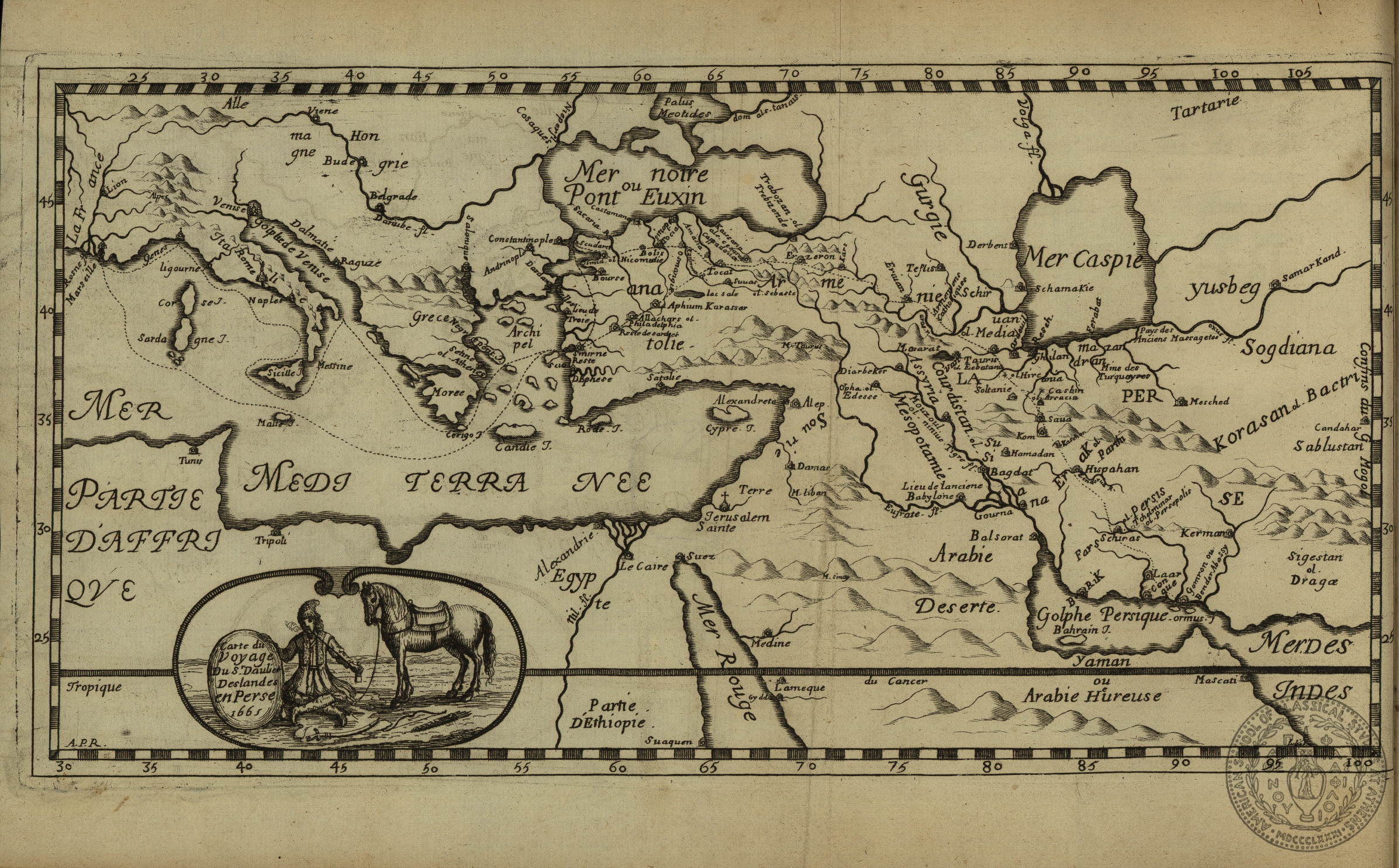
GT 531
In Book
Carte du voyage du s.Daulier Deslandes en Perse 1665
pl.I
1673
Deslandes
A.
Grevais Clouzier
Paris
Publisher
1 map
15,5 x 29,5
Europe -- Italy, the Balkans, Greece Asia -- Turkey, Irak, Iran Africa -- Egypt
ASCSA-G
2024
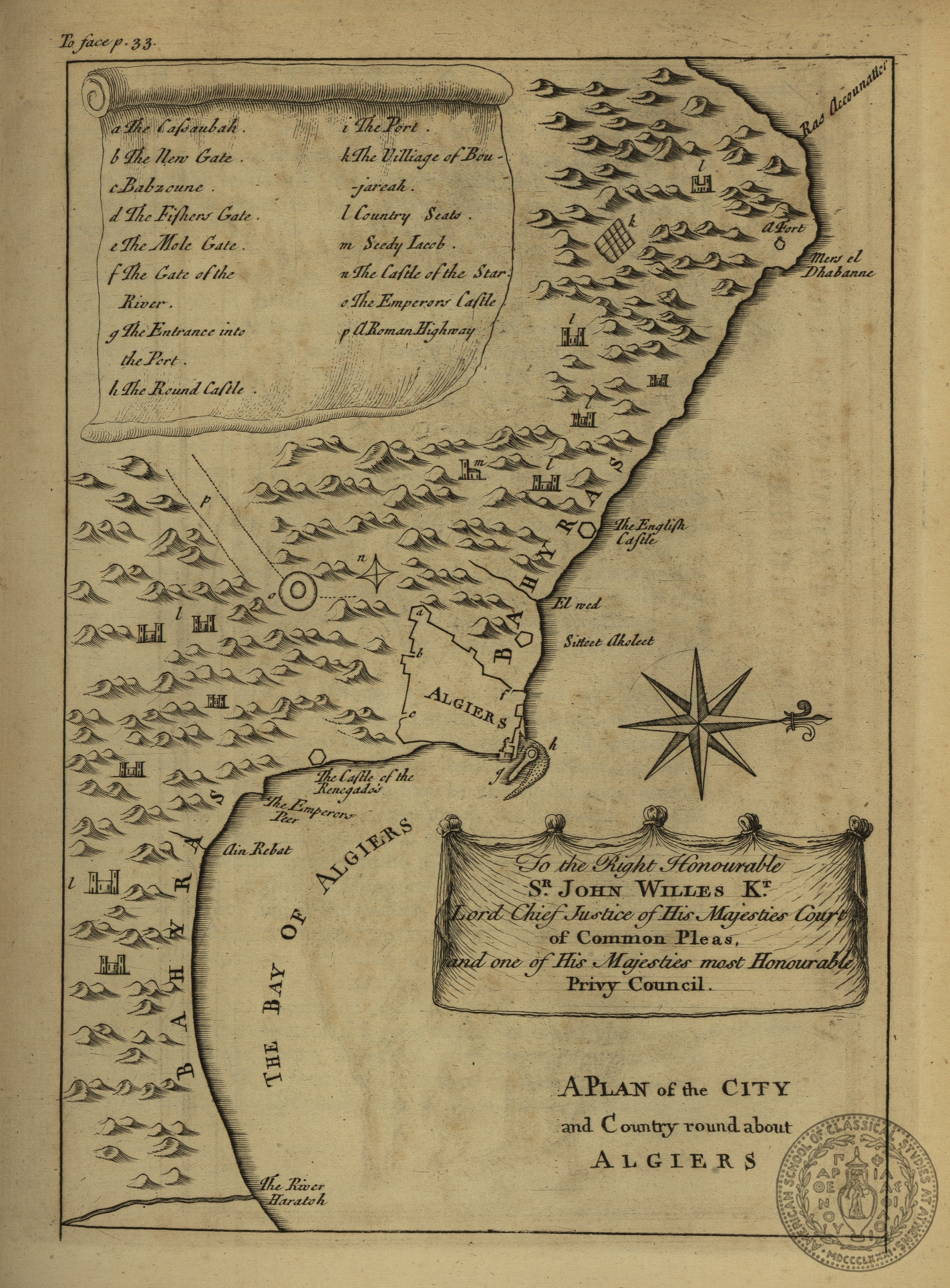
GT 638
In Book
A plan of the city and country round about Algiers
p.33
[1757]
[London]
1 map
23 x 16
Africa -- Algier -- redion of the city of Algier
ASCSA-G
2128

GT 638
In Book
A map of the eastern province of the Kingdom of Algiers
p. 43
[1757]
[London]
1 map
35,5 x 45,5
Africa -- Algier
ASCSA-G
2129

GT 638
In Book
A map of the Kingdom of Tunis
p. 71
[1757]
[London]
1 map
46 x 34
Africa -- Tunis
ASCSA-G
2130
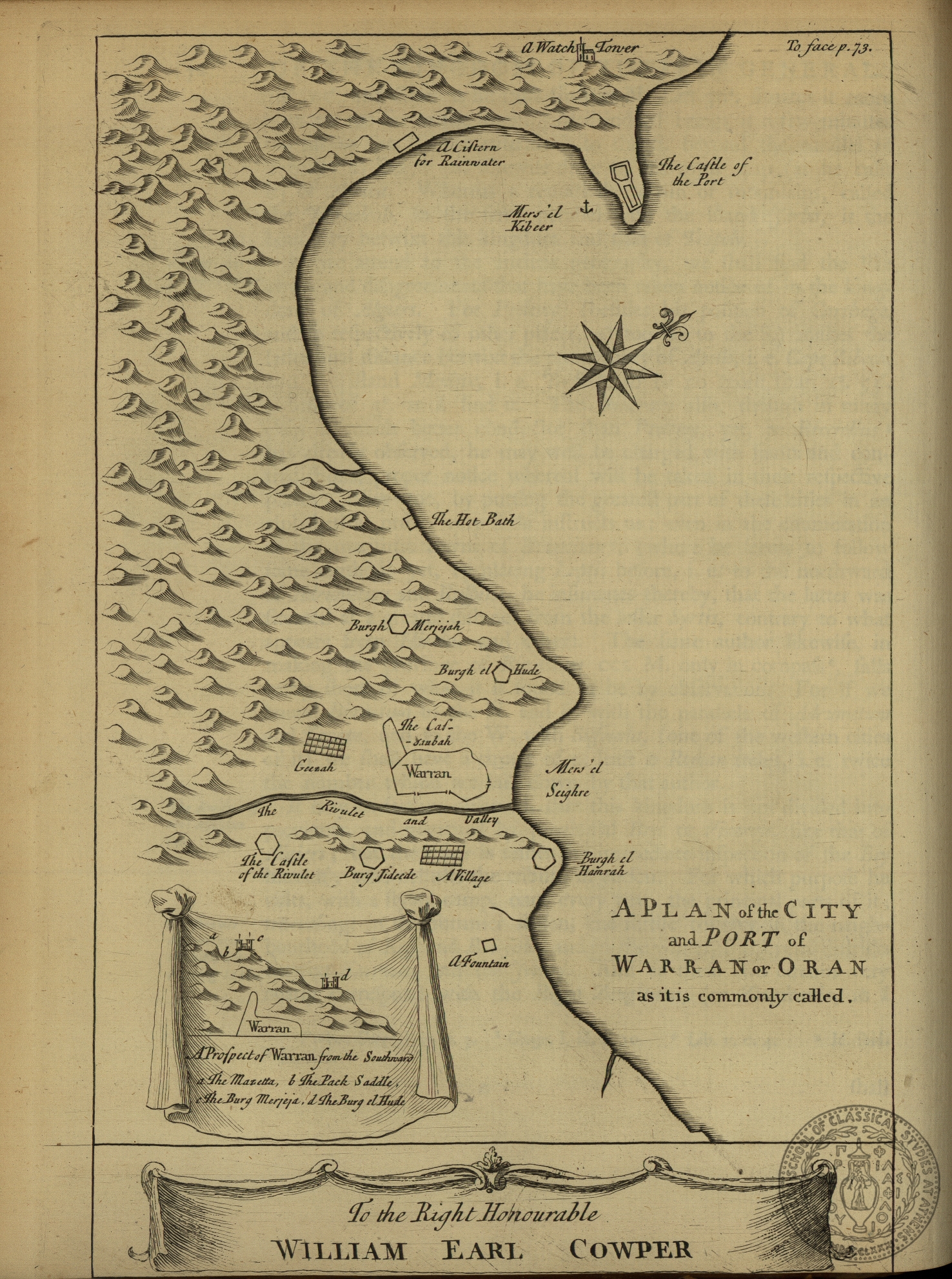
GT 638
In Book
A plan of the city and port of Warran or Oran as it is commonly called
p. 73
[1757]
[London]
1 map
25 x 16
Africa -- Tunis -- plan of the region of Oran
ASCSA-G
2131
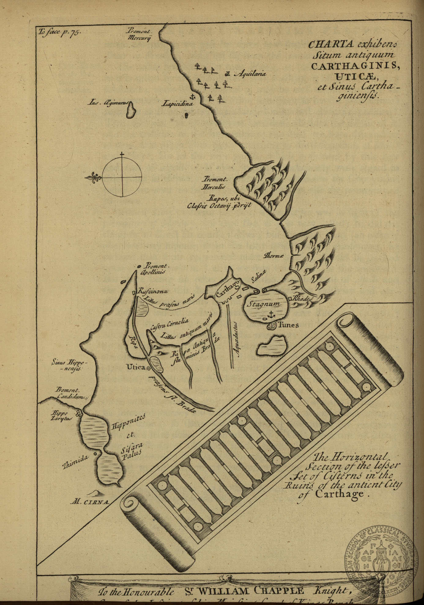
GT 638
In Book
Charta exhibens situm antiquum Carthaginis, Uticae et Sinus Carthaginiensis
p.75
[1757]
[London]
1 map
24,5 x 16
Africa -- Tunis -- the city of ancient Carthagine
ASCSA-G
2132
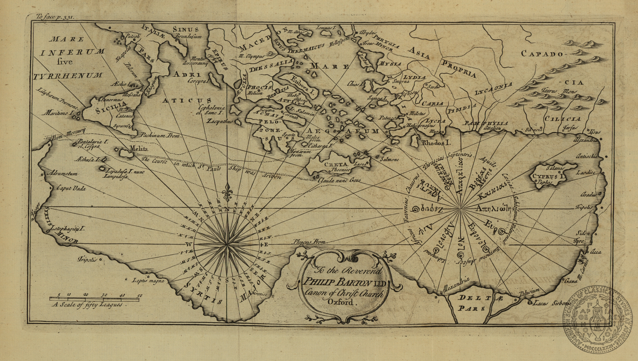
GT 638
In Book
Mare Inferum five tyrrhenum
p.331
[1757]
[London]
1 map
16,5 x 31,5
Mediterrenean Sea -- Italy, Greece, Turkey, northern Africa
ASCSA-G
2135

GT 640.v.1
In Book
Partie occidentale du Royaume d' Algier
with 1 inset: a map of Gibraltar The same map on GT 641 (Leipsig 1765)
p.1
[1743]
[Hague]
1 map
30 x 33,5
Africa -- Alger
ASCSA-G
2137
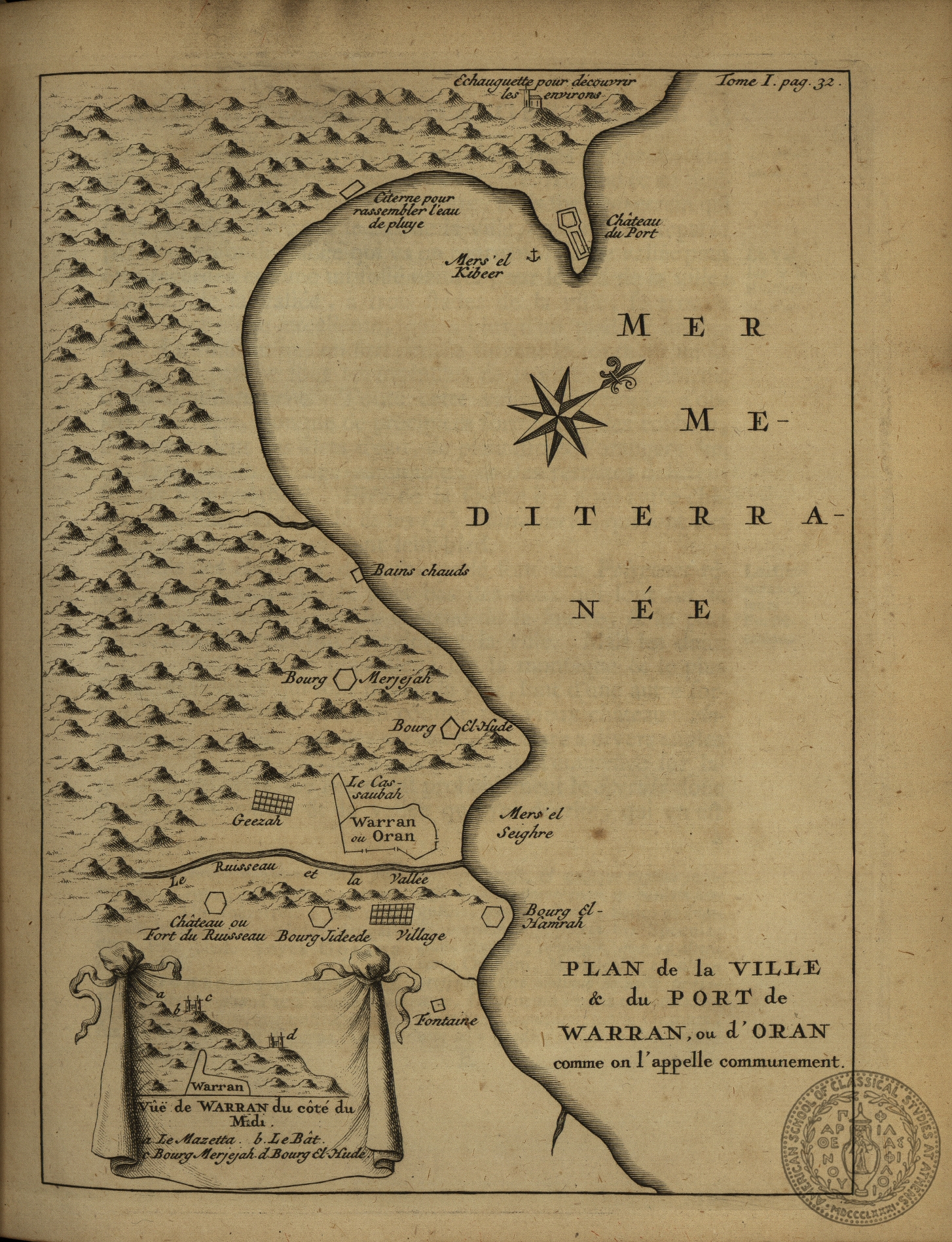
GT 640 v.1
In Book
Plan de la ville et du port de Warran ou d' Oran comme on l' appelle communement
p.32
[1743]
[Hague]
1 map
22,5 x 16
Africa -- Alger, region of the city of Oran
ASCSA-G
2138