

GT 319q
Loose
Mediterranean Sea…..
A hydrographic map
1881
Weller
E.
Admiralty
London
Publisher
1 map
105 x 64,5
Europe -- Mediterranean Sea, Italy, Greece, The Balkans, Turkey
ASCSA-G
1832
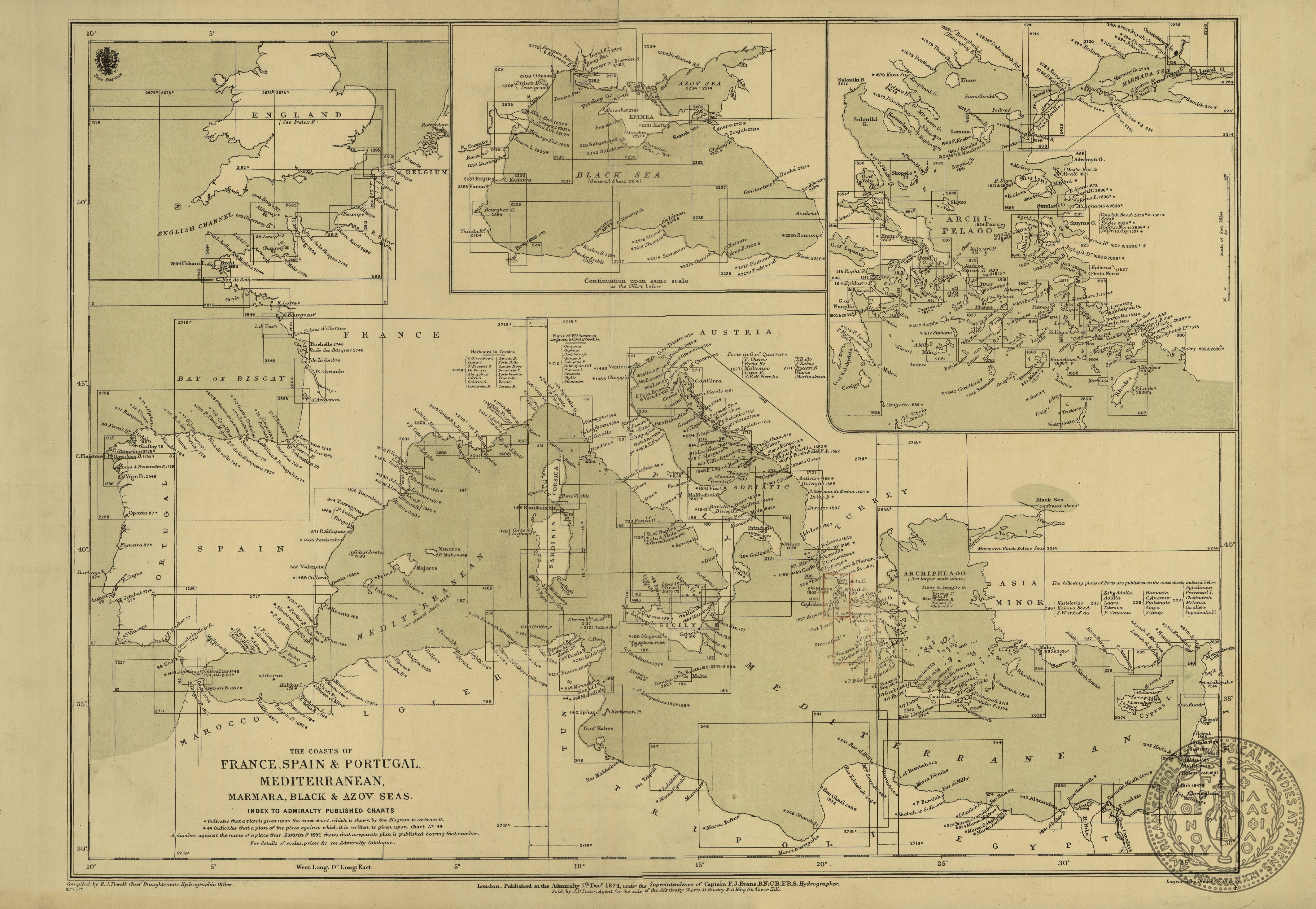
GT 225.1
Loose
The coasts of France, Spain and Portugal, Mediterranean, Marmara, Black and Azov Seas
with 2 insets: Black Sea, Aegean Sea
1874
Powell
E.
Admiratly
London
Publisher
1 map
35,5 x 49
Europe -- Mediterranean
ASCSA-G
2496
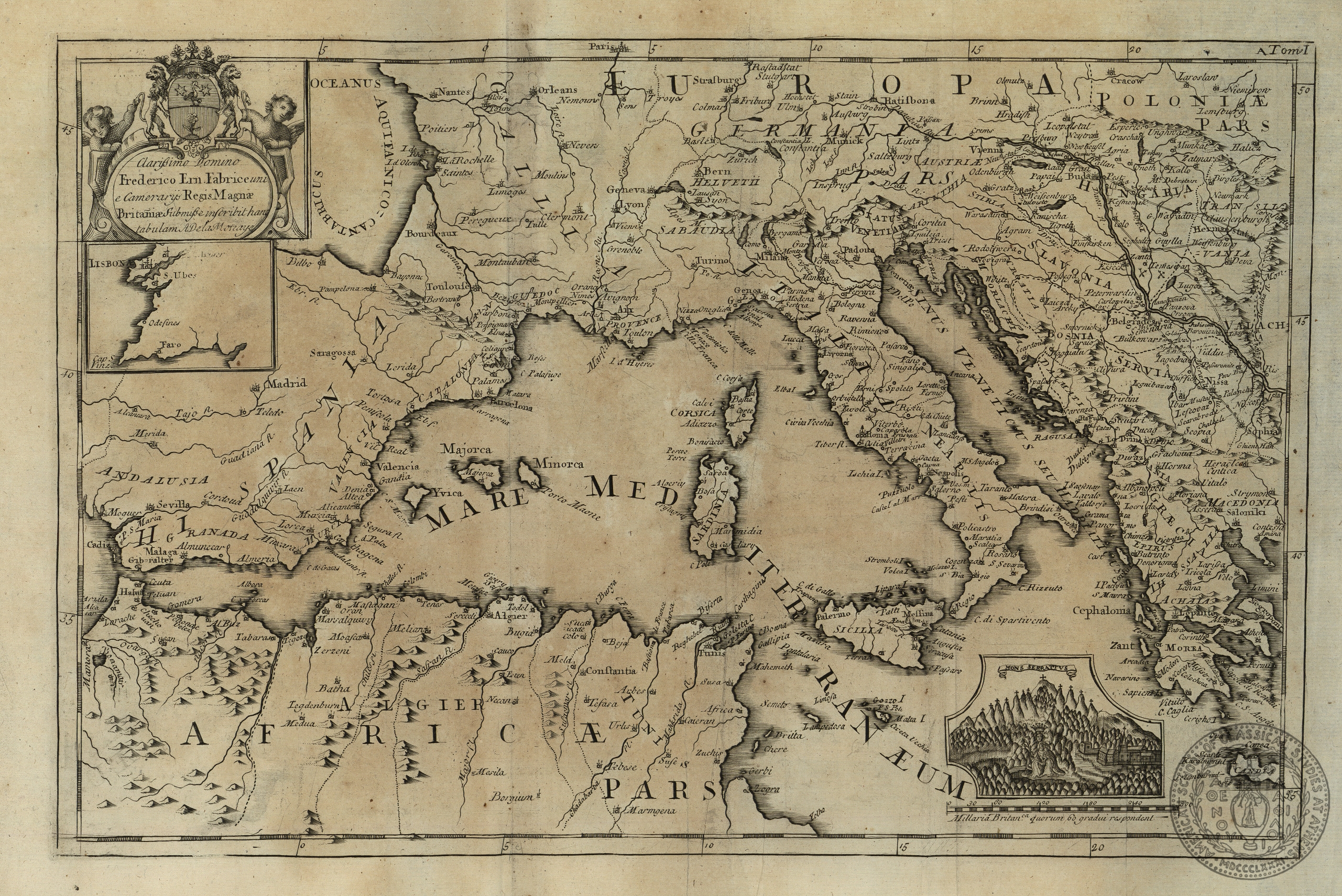
GT 607 Bq
In Book
[Map of the Mediterranean Sea]
with 2 insets: a map of a part od Portogall, a plan of Mons Serratus
pl. A
[1723]
Motraye
A.
[London]
1 map
27 x 41
Europe -- Mediterranean Sea
ASCSA-G
2589

PH 29.v.3
In Scrapbook
Voyage d' Enee. Tire de Virgile
loose leaf 2
1705
Fer
Nicolas
N. de Fer
Paris
Printer
1 map on 1 sheet
24.3 x 33.2 cms.
Europe-Mediterranean Sea
ASCSA-G
2625

PH 29.v.3
In Scrapbook
d' Avontuurlyke Reystogt van Johan Smith uit Engeland, over Zee en Land, na Duitsland, Italien, en Barbarye, tot in Turkyen en Tartaryen: Voyage fait au hasard par Jean Smith, tant par Mer que par Terre…
This map is within a wide border which measures 21.7 x 28.5 cms.It is depicts the travels of John Smith from England through Europe and the Mediterranean to Turkey and the Near East. It may have been published as early as 1714 in vander Aa's Nouvel Atlas,
leaf 52
[ca.1720]
Smith
John
Pierre vander Aa
Leiden
Publisher
1 map on 1 sheet
15.4 x 23 cms. See note.
Europe-Mediterranean Sea Asia-Turkey-Black Sea Asia-Near East
ASCSA-G
2664

PH 29.v.3
In Scrapbook
L. Rouwolfs Reys-Togten, door de levant, of Oosterse Land-Schappen der Middellandse Zee. Voyages de Leonard Rouwolf dans le Levant ou dans les pays qui sont a l'orient de la Mediterranee.
This map is within a wide border measuring in total 22 x 29 cms. It depicts the travels of the German botanist Leonhard Rauwolff. It contains an elaborate cartouche.
leaf 53
[ca.1720]
Rouwolf
Leonard
Pierre vander Aa
Leiden
Publisher
1 map on 1 sheet
15.4 x 22.5 cms. See note
Europe-Greece Mediterranean Africa-North Africa Asia-Turkey Asia-Near East
ASCSA-G
2665

PH 29.v.3
In Scrapbook
Imperii Turcici Europaei Terra, in primis Graecia…
This map contains a large cartouche with explanations for the reader, as well as marginalia which form the captions for the medals which are part of the title cartouche.
leaf 65
1741
Harenberg
Johann
Homann Heirs
[Nuremberg?]
Publisher
1 map on 1 sheet
48.7 x 56.5 cms.
Europe-Mediterranean Sea, eastern Europe-Italy-Sardinia-Corsica Europe-Greece Europe-Balkans Asia-Turkey Asia-Cyprus Africa-North Africa
ASCSA-G
2678

PH 29.v.2
In Scrapbook
Geographia Sacra.
This map contains an inset with a world map.
leaf 2
1598
Ortelius
Abraham
Abraham Ortelius
[Antwerp]
Publisher
1 map on 1 sheet
35.2 x 49 cms.
Europe-Southern Europe Europe-Balkans Africa-Coast of North Africa Asia-Middle East Asia-Turkey Mediterranean Sea
ASCSA-G
2710

PH 29.v.2
In Scrapbook
Geographiae Sacrae ex Veteri et Novo Testamento desumptae Tabula prima, quae totius orbis partes continet.
This map contains an inset of the Nile delta.
leaf 3
1662
Sanson
N.
Pierre Mariette
[Paris]
Publisher
1 map on 1 sheet
37.5 x 52 cms.
Europe-Southern Europe Europe-Balkans Asia-Middle East-Palestine Africa-North Africa Mediterranean Sea
ASCSA-G
2712

PH 29.v.2
In Scrapbook
Carte des regions et des lieux dont il est parle dans le Nouveau Testament…
With two inset maps: "Carte de la Judee sous Herode le Grand" and "Plan de Jerusalem du temps de N.S. Jesus Christ".
leaf 12
[177-?]
Bonne
Roberto
Paris
1 map on 1 sheet`
31x 44.5 cms.
Europe-Mediterranean Sea Asia-Turkey Asia-Middle East-Palestine
ASCSA-G
2720

PH 29.v.2
In Scrapbook
A correct chart of the Mediterranean Sea, from the Straits of Gibraltar to the Levant; from the lastest and best observations: for Mr. Tindal's continuation of Mr. Rapin's History.
With an inset of the Road of Leghorn (Livorno). This map is in the form of a portolan chart.
leaf 39
[17--?]
Seale
R.
Author
[London?]
1 map on 1 sheet
34 x 21 cms.
Mediterranean Sea Europe-Italy Europe-Greece Europe-Spain-coasts Africa-Coasts Asia-Middle East-Coasts
ASCSA-G
2745
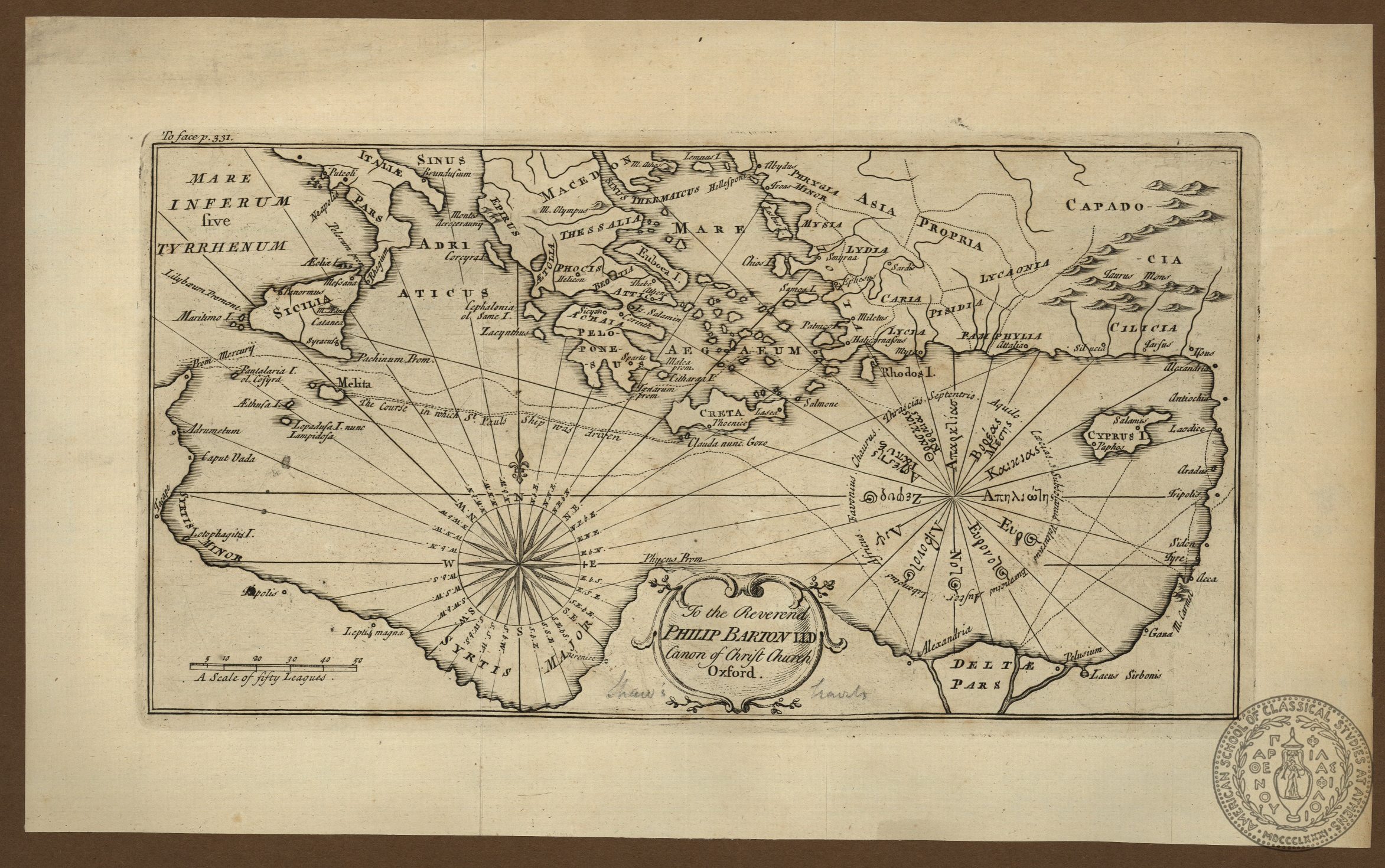
PH 49.v.1
In Scrapbook
[Eastern Mediterranean.] To the Reverend Philip Barton Ll. D. Canon of Christ Church Oxford.
scale bar: 4.8 cms = 50 leagues. Attributed by a note in Gennadius's hand to Thomas Shaw's "Travels or observations relating to several parts of Turkey and the Levant", London, 1738.
leaf 9v
1738
Shaw
T.
London
1 map on 1 sheet
16.5 x 31.5 cms.
Mediterranean Sea-Eastern Mediterranean
ASCSA-G
2883
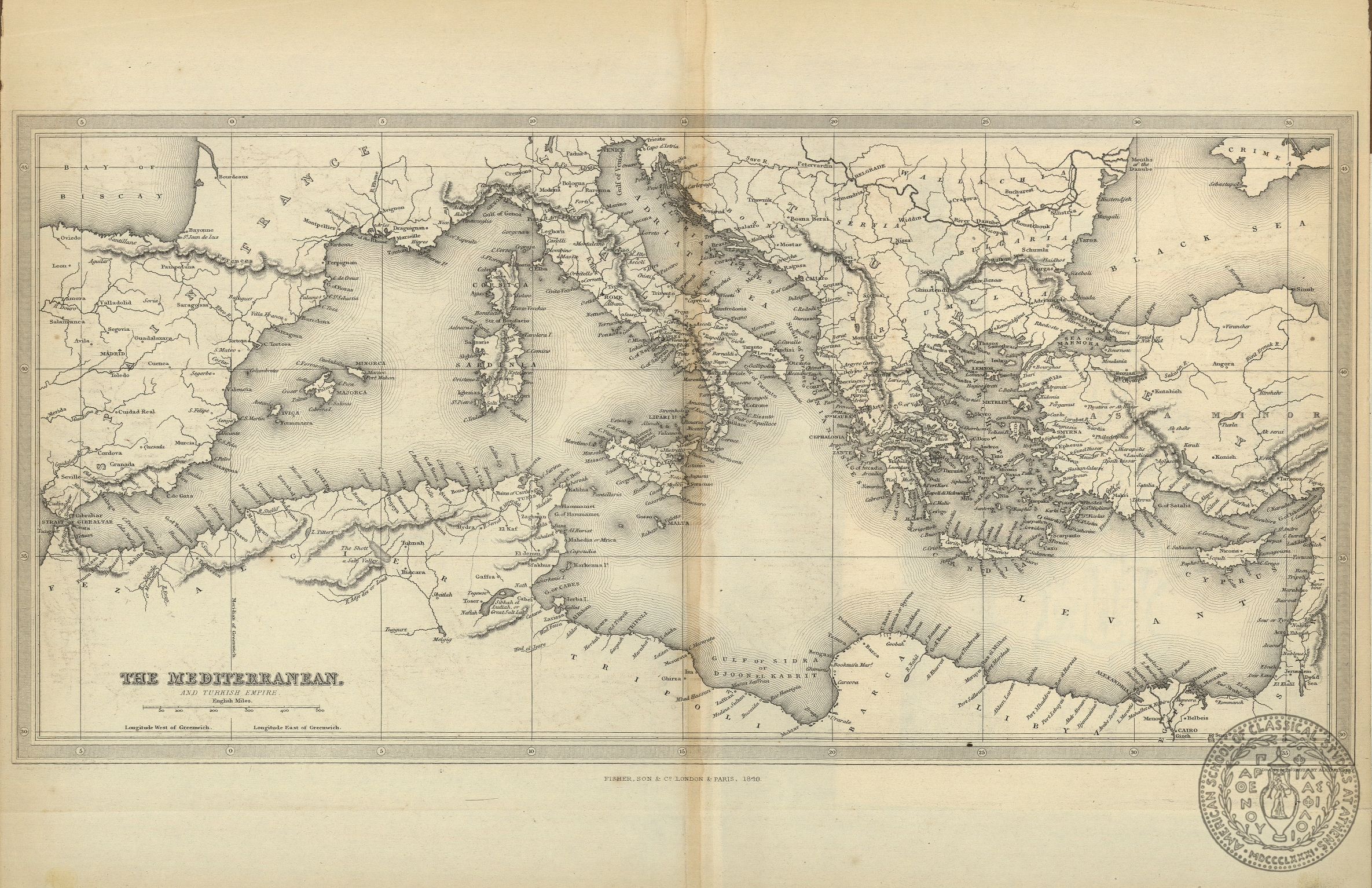
PH 49.v.1
In Scrapbook
The Mediterranean. And Turkish Empire.
This map is probably from Fisher's series "Turkish Empire Illustrated", either from the volumes by John Carne: "Syria, the Holy Land, Asia Minor", or by Walsh and Allom: "Constantinople and the Scenery of the Seven Churches of Asia Minor".
leaf 18b (f)
1840
Finlay
Alexander
Fisher Son & Co.
London
Publisher
1 map on 1 sheet
19.3 x 39.5 cms.
Mediterranean Sea
ASCSA-G
2889

PH 53.v.1
In Scrapbook
General Outline of the Author's route, as adapted to the First Section of Part the Second of these Travels, from D' Anville's troisième partie de la Carte d' Europe...
Scale not given. From Clarke's "Travels in various countries of Europe, Asia and Africa", 1810-1816. Clarke adapted this map from J. B. B. d' Anville's map of Europe.
leaf 6v (f)
1812
Neele
Author
Cadell & Davies
London
Publisher
1 map on 1 sheet
35.5 x 37 cms.
Mediterranean Sea- Eastern Mediterranean
ASCSA-G
3119

PH 53.v.1
In Scrapbook
Voyage par mer et par terre de Tripoli, Alep, Perse, Armenie, et des iles de la Mediterranee, tire des Memoires de Jean Newbery…
Scale bar: 4 cms = 100 milliaria gallica communs. This map is within an elaborate frame; with the frame the dimensions are 22 x 29 cms.
leaf 3
[1729?]
Pierre Vander Aa
Leiden
Publisher
1 map on 1 sheet
15.3 x 23 cms. See note
Mediterranea Sea-Eastern Mediterranean
ASCSA-G
3124

PH 56
In Scrapbook
Carte generale pour servir à l' intelligenc e de l' Histoire Sainte, pricipalement par raport à ses premiers ages.
Scale bar: 6.5 cms = 100 lieues de France de 25 au degré.
leaf 8
1783
Buache
Ph.
Dezauche
Paris
Publisher
1 map on 1 sheet
25 x 32 cms.
Mediterranean Sea-Eastern Mediterranean Europe-Cyprus Asia-Middle East
ASCSA-G
3169
PH 56
In Scrapbook
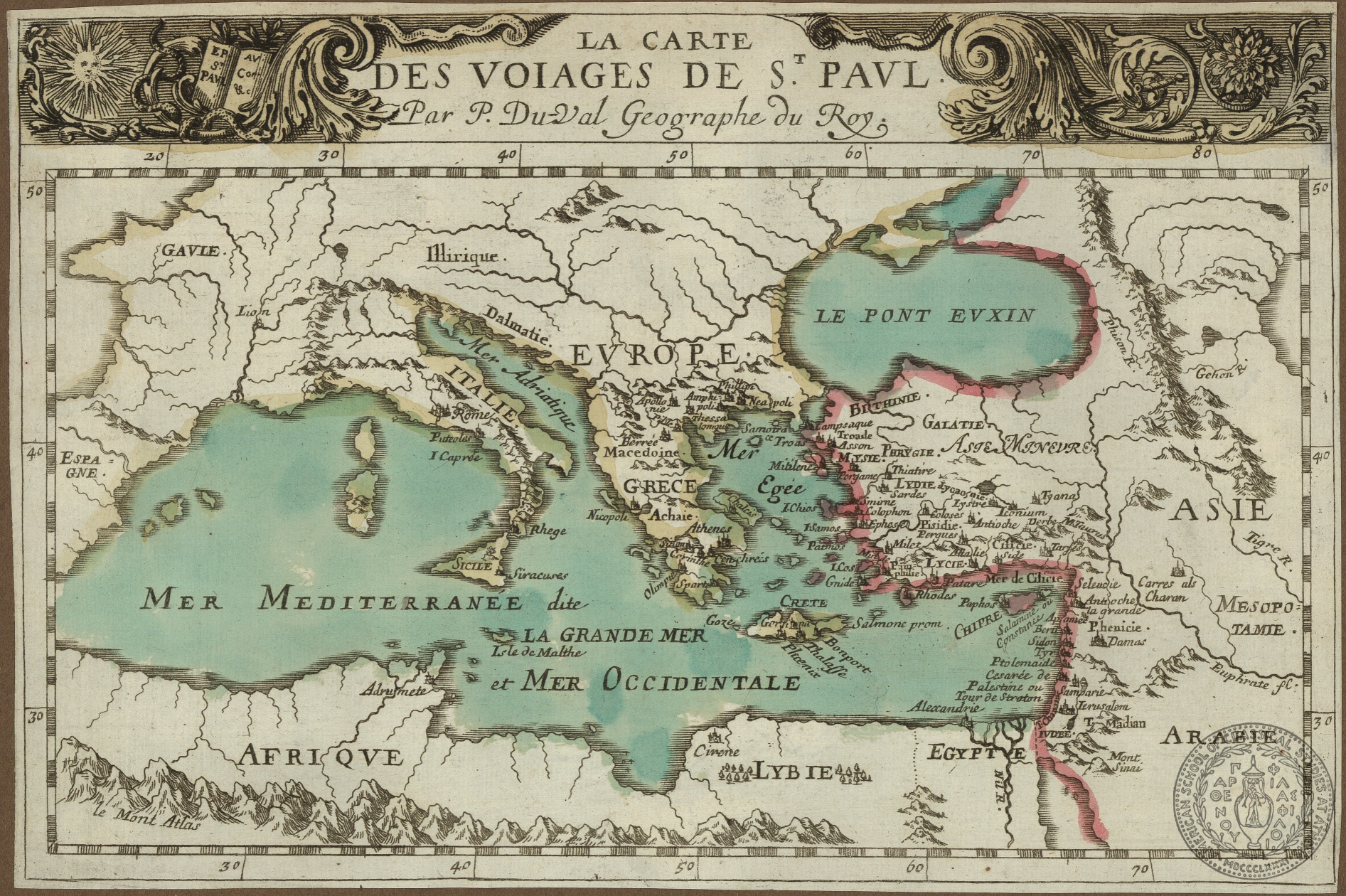
La Carte de voiages[sic] de St. Paul.
Scale not given.
leaf 4v.a
[16--?]
Duval
P.
1 map on 1 sheet
15.5 x 23.5 cms.
Mediterranean Sea-Eastern Mediterranean
ASCSA-G
3179
PH 32.v.1
In Scrapbook
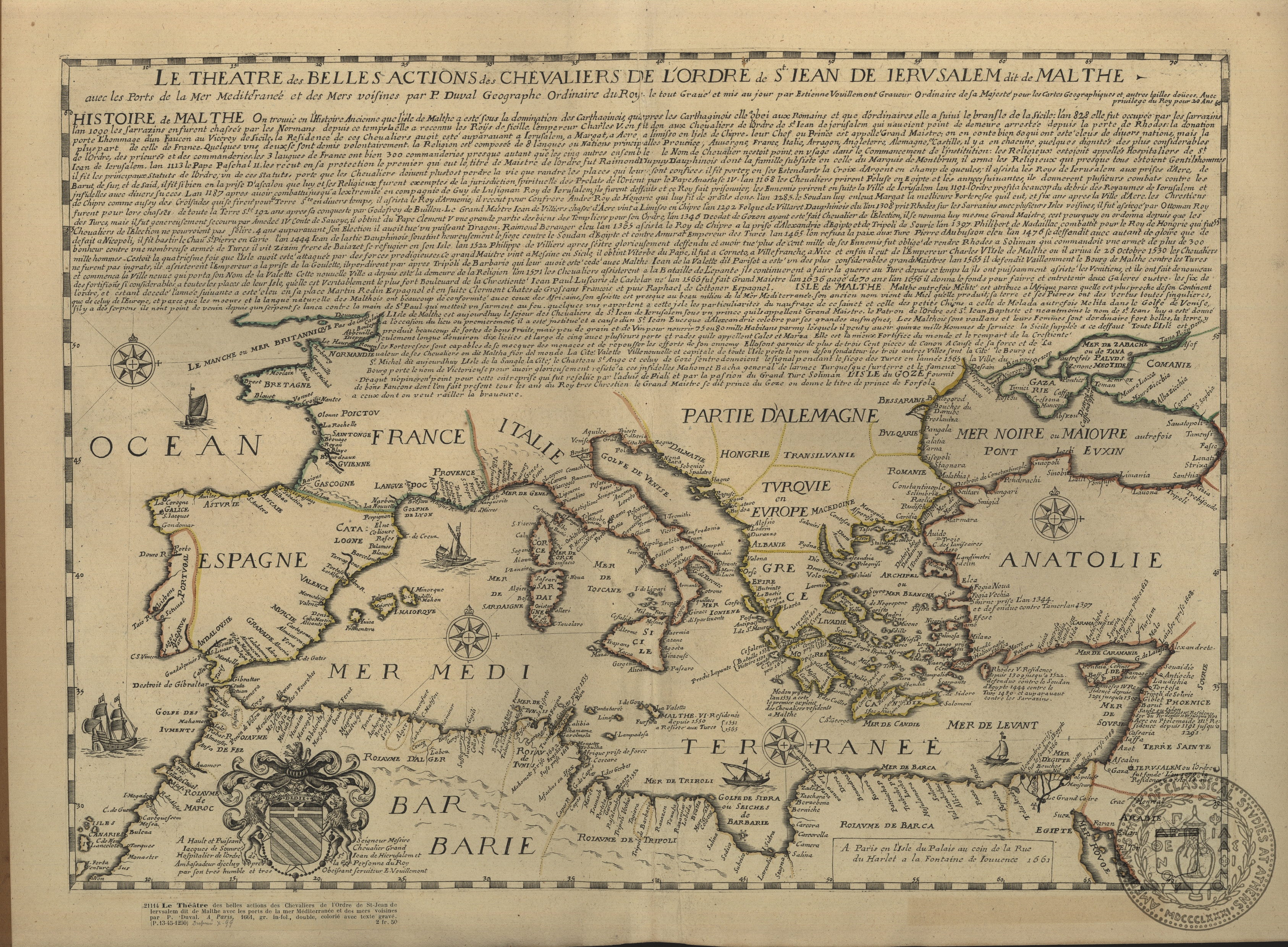
Le Theatre des belles actions des Chevaliers de l' Ordre de St. Jean de Jerusalem dit de Malthe avec les portes de la Mer Mediterranee et des Mers voisines.
Scale not given. There is a large engraved dedicatory cartouche to Jacques de Souvre, with his arms, by Vouillemont.
p. 61
1661
Duval
P.
Estienne Vouillemont
Pris
Publisher
1 map on 1 sheet
37.5 x 52 cms.
Mediterranean-Eastern Mediterranean
ASCSA-G
3238